| |
The Black Hole of White Canyon
- Cedar Mesa, Utah
| Summary: |
A scenic, fun
and exciting non-technical canyon hike with
plenty of swimming through ice cold narrows. To
complete this hike you will need: a wet or dry
suit (a shorty wet suit will suffice in hot
summer weather), and a dry bag. You may also
wish to bring: a flotation device (the author, a
rugged outdoorsman, uses a childs pool float toy
- please don't make fun, especially of the pink
one
 )
and a short rope to help less experienced
members down a few climbs. Do not attempt this
hike if rain is in the forecast, White Canyon
drains a very large area, the danger of flash
flood is very real! )
and a short rope to help less experienced
members down a few climbs. Do not attempt this
hike if rain is in the forecast, White Canyon
drains a very large area, the danger of flash
flood is very real!
Warning:
In Sept. of 2003 a flash flood formed large and
unstable log jams in the canyon. The canyon is
now considerably more difficult and dangerous to
negotiate. Reportedly you now need at least 100
feet rope and rappelling gear to get through.
Click
here for updated info. |
| Directions: |
The Black
Hole of White canyon is located on Highway 95
between Natural Bridges National Monument and
Hite Marina. The entry point begins at a large
dirt pull off directly across from milepost 57
on Highway 95, you'll exit just down the road
near milepost 55 (you can leave a second car or
mountain bike there if you have it). |
| Road Conditions: |
Passenger Car - paved all the way |
| Navigation: |
Moderate - some people have
reported a little difficulty in locating the
exit route from the canyon |
| Length: |
~5 miles
followed by a 2 mile road walk |
| Date Hiked: |
July, 2002 |
| Weather Conditions: |
Hot! |
|
Required Skills: |


 |
| Hike Description: |
From the
parking area across from milepost 57 on Highway
95, follow the dirt track which begins in the
left corner of the parking area. Follow the foot
path which veers off to the right a short
distance later and heads towards a prominent
side canyon. A sign (knocked over when the
author was here) at the top of this canyon reads
"Hiking in the Black Hole of White Canyon can be
hazardous. The water is deep and cold and flash
floods occur frequently. The narrow canyon
provides few escape routes. Enter at your own
risk." Read and internalize, the sign speaks the
truth. Follow the path behind the sign as it
picks it's way down the side canyon into the
main drainage of White Canyon. Turn left and
head down White Canyon. The canyon is rather
wide at first as you wind your way around a
boulder pile (easily bypassed on the left).
About 25 minutes into White, the canyon begins
to narrow and you'll have to negotiate a second
boulder field. Five minutes beyond you arrive at
your first swim (a distance of 50 ft or so).
After another short stretch of narrows you'll
come to another slotted pool, this one is easily
bypassed by walking on a ledge on the right.
Shortly below you'll reach a spot where large
boulders have fallen into the canyon creating a
drop off. Work your way around this obstacle on
the left hand side, then climb/slide down to the
canyon floor below. Your next challenge is a 20'
down climb along a slippery log into a waist
deep pool, followed by another boulder pile and
drop off which may also be passed by climbing
around and down on the left. Having made it this
far the only thing standing between you and the
Black Hole is a scummy pot hole. You can either
jump over the pot hole to the right hand side
where you can climb down, or, climb down and
swim through the pot hole itself (if water
levels are low, you may have to swim to the
right to a break in the rock in order to get
out). This makes for a good spot to pull on your
wet suit (and inflate your floaty toy). When
ready, perform a few short down climbs and begin
the first of two back to back extended swims.
This section is very cool and hopefully you'll
be warm enough to enjoy it. If you get tired of
swimming, the many rocks fins in the area
provide decent hand holds which will allow you
time to catch your breath, or alternatively,
simply wedge yourself between the rock walls
with elbows and knees to support your weight
above the water. There are a few more short
swims before the canyon gets a little wider.
Then it's mostly easy walking with a few boulder
scrambles to negotiate. Keep your eyes peeled
for a large natural arch which sits up on the
right hand wall. About 10 minutes after passing
the arch (if you happened to spot it), look for
breakdown on the left side of the canyon and a
few cairns. Follow the cairns as you ascend back
up canyon through a few layers until you reach a
prominent shelf just below the top most canyon
layer. The path then follows this shelf down
canyon for quite a ways until it winds it's way
into a prominent side drainage on the left.
Walking up this side canyon you'll be faced with
a few climbs, the first is a 25' climb up the
sheer face of a boulder (many good hand and foot
holds available). Immediately after this climb
look for the cairns to lead up to the left out
of the main drainage. Continue climbing until
you reach the top of the mesa above, and a short
trail which leads back to Highway 95 at milepost
55. Those without a shuttle will be faced with a
2 mile road walk back to their car. |
| Rating (1-5 stars): |

The author and his wife have completed this hike
on two different occasions, both in the summer.
On the last trip (after an extended dry period)
we proceeded at a leisurely pace, taking
advantage of the low water levels to get photos
in the narrows (bet you didn't know that a float
toy also doubles as a floating camera platform -
it's not so ridiculous looking now, is it?). The
hike was completed in 6 hours including the 2
mile road walk. |
| Maps: |
None used |
| Books: |
Canyon
Hiking Guide to the Colorado Plateau -
Michael Kelsey |
| Photos: |
Click picture for larger view, click your browser's 'Back' button to return to this page. |
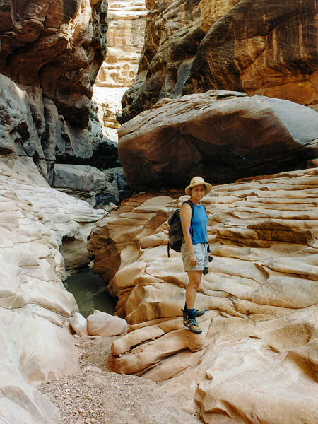 |
 |
The canyon begins
to slot up. |
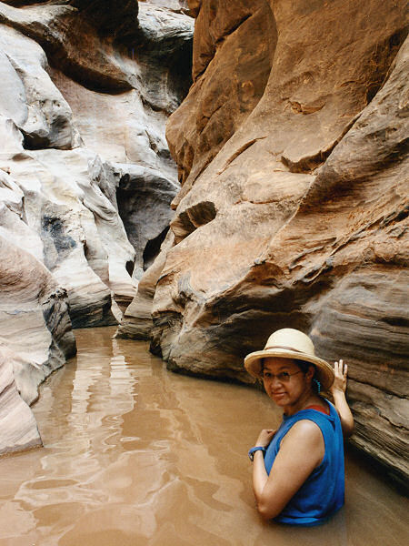
The first swim. |
 |
 |
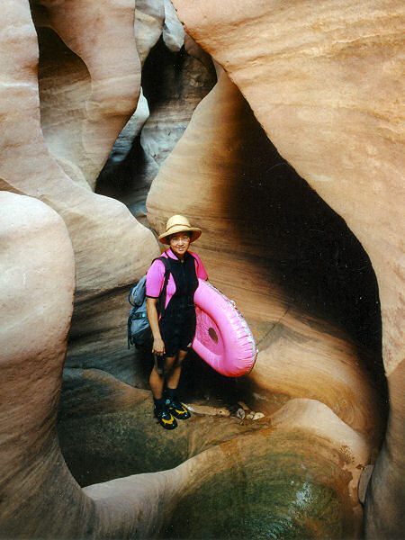
The beginning of
the Black Hole. |
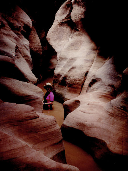
Within the Black Hole. |
|
|
