| |
Waterpocket Fold Narrows -
Capitol Reef National Park
| Summary: |
Four half day
hikes through canyons with good narrows in the
northern part of Waterpocket Fold. Expect to
do some wading in these canyons. Do not
attempt these hikes if the forecast calls for
rain. |
| Directions: |
The easiest
way to get to these canyons is from Utah
Highway 24. Drive west of Fruita and look for
the signed intersection for the Notom-Bullfrog
Road. Drive south on this unpaved, but well
graded road. These canyons are located one
after the other and are marked by a sign where
the road crosses it's drainage - they are (in
order north to south): Burro Wash, Cottonwood
Wash, Fivemile Wash & Sheets Gultch. Burro
Wash is about 7 miles south of Highway 24,
it's only a couple miles between each of the
others. |
| Road Conditions: |
Passenger Car,
though you'll save yourself some uninteresting
walking if you have a High Clearance
Vehicle |
| Navigation: |
Easy |
| Length: |
Arbitrary,
turn around when you want |
| Date Hiked: |
October, 2001 |
| Weather Conditions: |
Nice,
partially overcast |
|
Required Skills: |
None |
| Hike Description: |
Sheets
Gulch - Drive right up the wash of Sheets
Gulch as far as you can (a high clearance
vehicle will save you 15 minutes of walking in
an uninteresting wash). As you head up canyon
the canyon walls will gradually become steeper
and after a half hour you'll come to a
junction. The left junction ends in a rotary
about 300 feet later, so we'll turn right. A
short distance later you'll pass through a
short stretch of narrows with a few easy
boulder climbs. About 30 minutes past the
junction the canyon becomes predominantly
yellow Wingate sandstone and is not
particularly narrow, though it's nice enough.
The turn around point is arbitrary, head back
when you feel like it.
Fivemile Wash - There is no way to
drive up Fivemile Wash, so just find a place
to pull off the Notom-Bullfrog road and begin
hiking up canyon. The canyon is wide and
boring at first, then becomes deeper. About 45
minutes from the start of the hike you'll come
to a dryfall. A use trail on the left (facing
up canyon) leads up and around this obstacle.
Fifteen minutes later you'll reach a very
narrow and deep slot canyon which is likely
full of water (which was extremely rank and
unappealing when the author was there). I
chimneyed around the first pool, then waded up
a bit. It appeared that there was a 12 foot
climb that blocked further progress at that
point, however, it was difficult to see from
my position and didn't want to wade in the
nasty water any further than my waist, so I
turned around :) I then looked for a route
around by climbing high on the right canyon
wall (facing up canyon), but was stopped by a
steep slickrock slope (though it looked like
the slot continued for quite a while. Return
the way you came.
Cottonwood Wash - Drive up the wash as
far as you can go (a high clearance vehicle
will save you 15 minutes of trudging). After
30 minutes you will come to a dry fall that
can be passed on the left (facing up canyon),
then you'll cross a wide slickrock area. When
you come to an area with several large
boulders, look for the use trail that leads up
and around on the left (facing up canyon) to
avoid these obstacles. About an hour from the
start you'll come to an intersection (straight
and right), if you continue straight the
canyon boxes out about 200 feet further, so
we'll head right. There are a couple moderate
climbs as you pass through more boulders then
you'll hit a very large chockstone which
appears to block your path. There is a short
tunnel route beneath that allows you to
continue. Shortly thereafter you'll come to a
nice section of water filled narrows which
require deep wading or maybe swimming. The
author waded in a short distance, but the
water was ice cold, so turned around when it
became greater than waist deep.
Burro Wash - Finally a good one! Once
again, drive up the wash as far as you can go
(a high clearance vehicle will save you 30
minutes of walking). Same as before, walk up
the dry boring wash until the canyon deepens.
After about an hour of walking the canyon
slots up nicely and you'll be in and out of
some very tight shoulder wide narrows. Once
past this section you'll reach a wider area
with some small trees growing right in the
wash and some boulder climbs ahead. Continue
up and around the boulders then wade through a
small pool to a short, but very deep and
pretty slot canyon. The slot boxes out a short
distance later in a room with a high dry fall
(which must be great when flowing). If you'd
like to explore further, head back down canyon
just past the trees and look for a cairned
route on canyon left (left side of the canyon
when facing down canyon). You can climb up and
around the narrows and dry fall by following
the cairns up the slick rock to the ridge you
can see high on the canyon wall (note: this
route is rather tricky and potentially
dangerous, with some travel on a very steep
slick rock slope required, do not even attempt
this route if wet). If you do decide to
continue, follow the cairns up the steep
slope, then up to the exposed ridge. The ridge
will allow you to walk up past the dry fall,
then follow the cairns down to the canyon
bottom once again. Unfortunately the canyon
enters the yellow Wingate Sandstone at this
point and is not as interesting as the narrows
below. When ready, return the way you came. |
| Rating (1-5 stars): |
 - Sheets Gulch,
Fivemile Wash, and Cottonwood Wash
- Sheets Gulch,
Fivemile Wash, and Cottonwood Wash
- Burro Wash
My initial information prior to hiking these
canyons was very sketchy. In Burro Canyon we
met some people that had a small spiral bound
book entitled 'Exploring Capitol Reef' (?
- or something to that effect). They let us
look at it and it seemed to have some great
write ups for these canyons. According to
these hikers the book is available at the
Capitol Reef visitors center for less than
$10. I would suggest picking up this book if
heading into this area (which was also my
plan, but the visitors center was closed when
I arrived).
The author and his wife spent about 2 1/2
hours each exploring Sheets Gulch, Fivemile
Wash, and Cottonwood Wash. We spent 4 hours exploring Burro Wash. The author hiked the cairned route around the dry fall in the upper part of
this canyon, then headed back down to try to look into the dry fall from above, but was stopped by several large drop offs that occur in the stream bed just prior to the large falls. |
| Maps: |
USGS - Notom
(1:62,500) |
| Books: |
Canyon
Hiking Guide to the Colorado Plateau -
Michael Kelsey |
| Photos: |
Click picture for larger view, click your browser's 'Back' button to return to this page. |
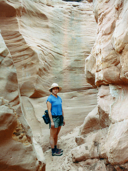 |
 |
| Narrows
in Sheets Gulch. |
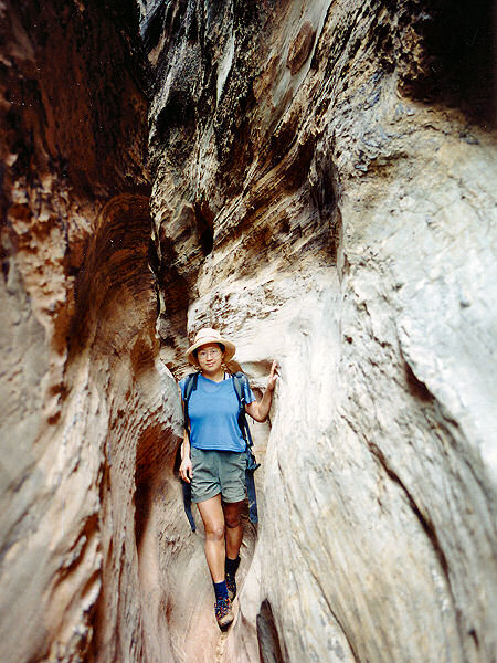
The
deep dark narrows in
the upper end of Burro Wash. |
|
|
