| |
Rock Creek Loop - Tonto National Forest
| Summary: |
A seldom traveled, strenuous
loop hike in the Four Peaks Wilderness with over
3600 feet of elevation gain and long stretches
of brushy, poorly maintained trail. |
| Directions: |
Drive
northeast out of Phoenix on the Bee Line Highway
(Highway 87) towards Payson. Turn right (south)
onto Highway 188 and drive 24.4 miles to between
mile markers 232-231 and turn right at the sign
for 3 Bar Road (which is also Forest Road 445).
Follow this fairly well graded dirt road 3.1
miles (following the signs for the Rock Creek
Trailhead) to a 'T' junction. Turn left onto FR
445A, then take the next right and drive down
the hill to the parking area and trailhead. |
| Road Conditions: |
High Clearance Vehicle
(though I believe a passenger car might make
it?) |
| Navigation: |
Difficult |
| Length: |
13.9 miles |
| Date Hiked: |
February 2006 |
| Weather Conditions: |
Partly cloudy, windy and cool |
|
Required Skills: |

 |
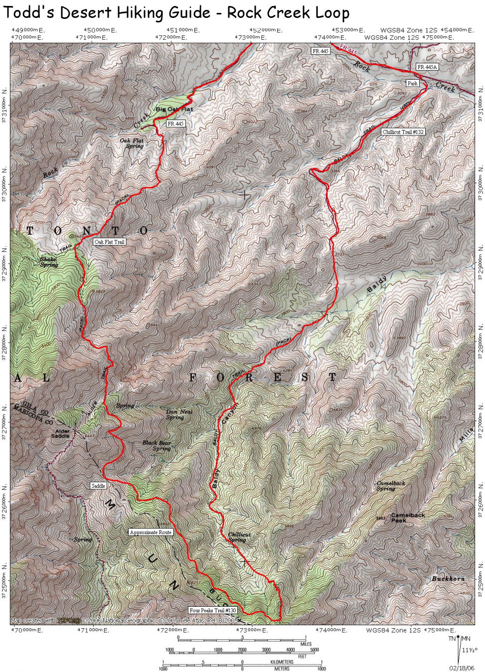
| Hike Description: |
From the parking area (0
miles, 2880 ft), walk across the dry wash and
past a sign for the Chillicut Trail #132. The
path winds its way along a dry wash for a short
distance, then makes a quick jog to begin
climbing a ridge along an old road. The ridge
travels between rolling, scrubby hills which
show considerable evidence of fire damage. The
path climbs at a moderate grade for a while,
then suddenly makes a sharp left, dropping off
the ridge to cross a wash only to begin climbing
once again. After some additional altitude is
gained, a saddle is reached which features a
Chillicut Trail sign and arrow which points in
an inexplicable direction. Turn left (do not
stay straight on the road) at this sign,
following a rutted track that drops off the
ridge into a wide basin below. The path becomes
rather faint as it crosses the basin, but is
marked with cairns at fairly frequent intervals.
Eventually, the path bends to the right and
begins a steep ascent along a series of ridges.
The trail becomes extremely faint to
non-existent in this section, watch carefully
for cairns. After switching ridges, the path
levels out, then drops steeply down into the
drainage of Baldy Canyon (flowing when I was
here). Immediately after crossing the streambed,
you'll pass by a Four Peaks Wilderness Boundary
sign. The path then follows the wash on one side
of the creek bed or the other. As you ascend
next to the wash, the water fades underground
and the trail becomes more faint, overgrown and
unpleasant (fortunately the majority of the
growth lacks sharp thorns). Eventually the faint
path climbs out of the wash and climbs steeply
up the hill at the head of the drainage (keep
your eyes open, the track is difficult to follow
and fallen trees disguise the route). After
gaining some additional elevation you finally
top out at a 'T' junction with the Four Peaks
Trail #130 (5.7 miles, 6500 ft), which is also
the Arizona Trail. Turn right onto the Four
Peaks Trail which is considerably more distinct
(though overgrown in spots) and level as it
traverses the hillside in the direction of its
namesake, eventually crossing a prominent saddle
just below the peaks. The path crosses the
saddle and then bends right to continue
traversing the hillside. About a mile later
you'll come to a signed junction with the left
branching Alder Saddle Trail #81 (8.6 miles),
continue straight on the Four Peaks Trail as it
continues its traverse with good views down into
the valley, and Roosevelt Lake far below and the
Sierra Anchas beyond. After rounding a little
promontory which has a large fire ring on it,
the path begins dropping steadily to eventually
reach a signed junction with the right branching
Oak Flat Trail #123 (9.7 miles, 5400 ft). Turn
right onto the Oak Flat Trail which soon passes
a wilderness boundary sign and begins descending
steeply along a deeply eroded, 'V' shaped track.
The path basically drops off the mountain and
only levels out upon arriving at the Oak Flat
Trailhead and Forest Road 445 (11.1 miles, 3675
ft). Turn right and follow this road (ignoring
any branches) 2.6 miles to the junction with FR
445A (13.7 miles). Stay straight on FR 445A then
turn right a short distance later to return to
the trailhead and your car (13.9 miles, 2880
ft). |
| Rating (1-5 stars): |


Although there are some nice views on this
hike from the Four Peaks Trail, the downright
unpleasant Chillicut Trail and 3 mile road walk
make for a rather mediocre trip overall.
The author completed the
hike at a fast pace in 6 hours. |
| Maps: |
Tonto
National Forest Map, or click
here (note: this
route is approximate) |
|
Books: |
Hiking Arizona's Superstition and Mazatzal
Country
- Grubbs, Bruce |
| Photos: |
Click picture for larger view, click your browser's 'Back' button to return to this page. |
 |
 |
|
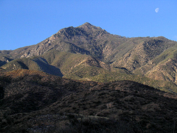
View from the Chillicut Trail. |
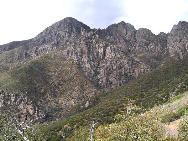
Brown's Peak from the saddle. |
 |
 |
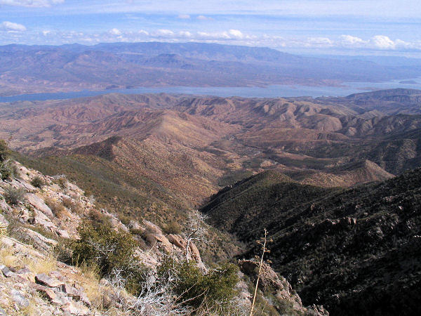
Roosevelt Lake from the Four
Peaks Trail. |
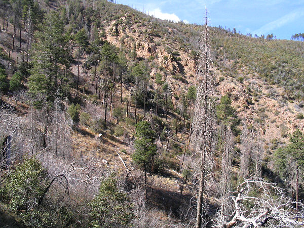
Descending the Oak Flat Trail. |
|
|
