| |
Haunted Canyon & Semi-Loop - Tonto National Forest
| Summary: |
A long streamside hike in the eastern
Superstitions. If you like forested walks beside gurgling brooks, this is
the hike for you. |
| Directions: |
From Phoenix, drive east
on Highway 60 12.8 miles past the town of Superior. Turn left onto Pinto
Valley Rd (FR 287) and the entrance to the Pinto Valley Mine. The
paved road leads 2.7 miles to a main entrance to the mine
headquarters. At the mine entrance, turn left (following the "Public
Access" signs) onto a dirt road that passes through the mine
property. Stay on the main route (following the "Public
Access" signs) as the road
drops down past a few evil looking tailings ponds. After driving 6.7
miles from Highway 60 you will come to a split in the road marked with a
white sign that reads "Peak Well 26-29", turn left at this
sign. A short distance later you will see a brown Forest Service
sign pointing ahead to Haunted Canyon Trail #203. When the author
was here the road was closed a short distance past the sign due to high
water levels in Pinto Creek. If the road is open drive to the end
and park next to the old coral (staying right at the one split in the
road), otherwise you'll have to park next to the gate and take a 1/2 hour
walk to the trail head. Note: where the road crosses the stream it may be difficult to cross without getting your feet wet. If this is the case, walk up stream a few hundred yards until the sound of the water increases. There are enough rocks and branches at that point that you can jump to the other side and continue down the road. |
| Road
Conditions: |
Passenger Car |
| Navigation: |
Moderate: there are a couple spots that
are confusing, take extra care since this is a long hike. |
| Length: |
12 miles (Haunted Canyon out & back)
21.1 miles (Haunted Canyon with Semi-Loop)
+ perhaps an hour road walk if road is closed |
| Date
Hiked: |
March 2001 |
| Weather
Conditions: |
Nice, highs in the lower 60's, partly cloudy with afternoon sprinkles. |
|
Required Skills: |

 |
| Hike
Description: |
From the coral a brown Forest Service sign with
the universal hiker symbol marks the entrance to the Haunted Canyon Trail (#203).
The trail heads up to the right then drops down to follow Pinto Creek through a shady
forest of Arizona Sycamore, juniper and cottonwood. You will follow a barbed wire
fence for a while, then the trail heads up onto the slope on the right to avoid a
narrow section in the canyon. After a short distance you drop down once again and
continue following the stream up canyon. The trail is not terribly distinct in
places, but it is marked with cairns and pink flagging tape, you can't get lost
though - if you're next to the stream, you're on the trail. There are numerous
stream crossings as you head upstream, a walking stick is useful in this section
for balance when hopping from one dry rock to the next and to pole vault some of
the wider pools. Eventually you will reach Tony Ranch Spring, a nice, forested
area with a large fire ring, coral and overturned water trough that is obviously
used for a couch. There are plenty of good camping spaces in this area. The trail
bends right at the camp - follow the large cairns and walk about 10 minutes to the
junction with the left branching Bull Basin Trail (#270). The distance from the
trail head to this junction is 6 miles (6.0 miles). A hike to Tony Ranch Spring
and back would make a good 12 mile day hike. We, however, will continue onwards and complete an
additional loop at this point. Stay right on the Haunted Canyon Trail which crosses
the stream and begins a series of steep switchbacks up the hill on the other
side. After reaching a saddle, the trail then follows a tributary of Pinto Creek
and climbs more moderately beside this small stream. The trail along this section
is more exposed traveling up a sunny chaparral covered slope consisting mainly of manzanita, jojoba, sugar sumac and scrub oak. After 1.3 miles (7.3 miles) you will
reach the junction with the left branching Paradise Trail (#271), turn left onto
this trail. The Paradise Trail continues upwards to a saddle where numerous use
trails seem to branch off along the left slope and a ½ destroyed sign for 'Tony
Ranch 2 miles back' can be seen. Walk directly across the saddle and look for the
overgrown trail which descends the other side. The trail, which is somewhat faint
in places, meets up with another stream and follows it down canyon through the scrub oak. Eventually the scrub fades back
(thank goodness) and will find yourself back in a shady forest on a gently descending
path besides a gurgling stream. Further along you will reach an old coral and a short
distance later you will reach FR 287A the road which leads to the Miles Trailhead.
Turn left on the road and walk about 2 minutes to the sign pointing the way to
Trail #212 on the left (10 miles). Pass by the large Tonto National Forest sign for
the Miles Trailhead and look for the gray Superstition Wilderness sign and just
below, a brown universal hiker sign which marks the entrance to the West Pinto
Trail (#212). Follow this level trail 0.6 miles (10.6 miles) as it passes by an
old concrete foundation, then past a wide, open field. When you reach a stream you
will come to the signed junction with the left branching Rock Creek Trail (#195),
turn left onto this level trail which follows the stream, crossing it several times
along the way. After 0.7 miles (11.3 miles) you will reach the signed junction with
the Bull Basin Trail (#270), turn left onto the Bull Basin Trail. This section of
trail begins climbing moderately to steeply for about a mile before topping a rise
then climbs more moderately beside yet another stream up through Bull Basin. After
passing a coral the trail becomes considerably more overgrown and steep as it climbs
out of the canyon to a saddle. You then pass through a gap in the fence at the saddle
and drop steeply down the other side, following a similar drainage beside a stream
on another somewhat overgrown scrubby trail. Eventually you will rejoin the Haunted Canyon
Trail (15.1 miles) which you will follow, retracing your steps, back to the trailhead
(21.1 miles).
|
| Rating
(1-5 stars): |
 
The author completed this hike solo in 7 hours walking briskly the entire way (8 hours with the added road walk). All the streams were flowing due to recent rains. |
| Maps: |
Beartooth Maps -
Superstition Wilderness Topographic Map |
| Photos: |
Click picture for larger
view, click your browser's 'Back' button to return to this page. |
|
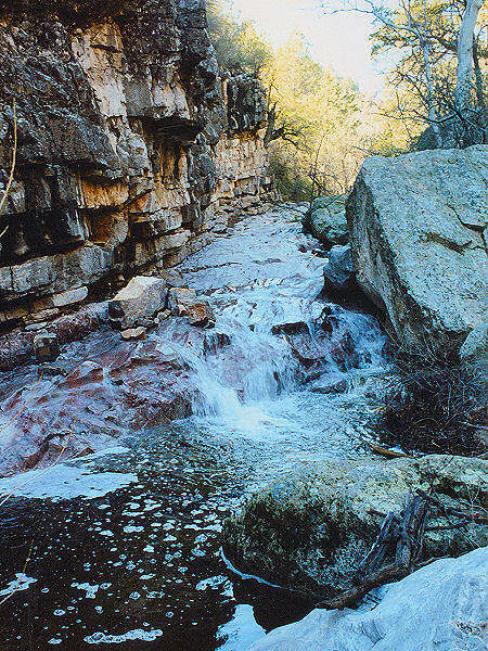 |
The stream in
Haunted
Canyon. |
|
|
