| |
Hells Hole - Salome Wilderness, Tonto National Forest
| Summary: |
A nice stroll through the woods from the Reynolds Trailhead to an area of Workman Creek known as Hells Hole, then a brushy hike downstream to a falls and narrows. |
| Directions: |
From Phoenix drive east on Highway 60 almost to Globe. Turn left (north) on Highway 188 (also listed as 88 on maps) and drive 14.4 miles to Highway 288. Turn right on 288 which is paved at first and after a short distance crosses the Salt River on a single lane bridge. After 12.2 miles you will come to an intersection with left branching A Cross Road. Continue straight on Highway 288 for another 15 miles to the sign and turn off on the left for Reynolds Trailhead and camp. |
| Road Conditions: |
Passenger Car |
| Navigation: |
Easy |
| Length: |
~12 miles (?) depending on your turn around point |
| Date Hiked: |
January 2002 |
| Weather Conditions: |
Nice, highs in the upper 60's |
|
Required Skills: |

 |
| Hike Description: |
From the trailhead parking area, walk through the stile in the fence and begin following the wide dirt trail up hill (the trail at this point looks as if this used to be an old road). About 100 ft in you will come to a sign for the Hells Hole Trail (284) 6 miles, Boyer Trail (148) 2 miles. Note: Based on my walk time I do not believe either of these mileages to be terribly accurate, I'm guessing the Boyer Trail is 2.5 miles away & Hells Hole 5 miles. The trail tops out at a shoulder then begins descending moderately through a ponderosa pine forest interspersed with manzanita,
alligator juniper, agave & emory oak. At Armer Ranch the trail bends right, paralleling the drainage of
Workman Creek for a short distance before dropping down into it. After crossing the creek (flowing when the author was here) the trail begins a moderate ascent past a Salome Wilderness, Tonto National Forest Boundary sign. The path eventually levels out at the top of a scrubby hill and shortly thereafter you will reach a signed junction with the leftt branching Boyer Trail. Continue straight on the Hells Hole trail which soon begins to descend a rocky slope towards a prominent tributary of Workman Creek. Just before reaching this drainage, the trail heads right, runs parallel to this canyon for a short distance, then begins a long and moderately graded descent towards Workman Creek along a series of long switchbacks. The path finally reaches the bed of Workman Creek (a nice stream flowing through a pink boulder strewn canyon) then heads down stream a short distance past some nice campsites before disappearing altogether. This spot might make a nice destination for a day hike. If you care to explore further, you can make your way down stream by rock hopping and bush
whacking along one side of the creek bed or the other. The stream occasionally passes through some short stretches of canyon with pink granite walls (nothing terribly impressive) until an hours walk brings you to point where the stream cuts it's way deeply into the rock forming a cool 45 ft falls and interesting stretch of canyon below. It is possible to get down this drop off by heading along the rim on the right side of the canyon to a point where a break in the rock allows you to climb down, but it is not user friendly. If you manage to get down, it's more bush
whacking and rock hopping until a short time later you reach the confluence with Salome Creek. You can explore upstream or down from this point (or continue down stream as part of a longer hike down to the 'Jug'). The author explored a little in both directions before returning. Down stream, the canyon appeared shallow with many deep pools. Upstream looked incredible with beautiful narrows, drop offs and pools. Unfortunately I wasn't able to get very far upstream due to dry falls (perhaps there's a way down from above?). |
| Rating (1-5 stars): |

The author completed this hike solo, walking down to the falls in lower Workman Creek. I intended to walk all the way down to Salome Creek, into which Workman drains, but could not make it past the falls through the underbrush. On the way back, I walked up the Boyer Trail for an hour (nice easy hike along very flat terrain) before returning to my car for a total walk time of 7 hours. At a later date the author returned and found a way down the falls (on the right) to the confluence with Salome Creek, then returned. Total walk time was 9 1/2 hours. I know there are great narrows in the upper Salome drainage (see Arizona Highways dated August 2001). I'm just not sure the effort to see them is worth it. The thick brush and bush wacking makes for a rather unpleasant experience. |
| Maps: |
Tonto National Forest Map |
| Photos: |
Click picture for larger view, click your browser's 'Back' button to return to this page. |
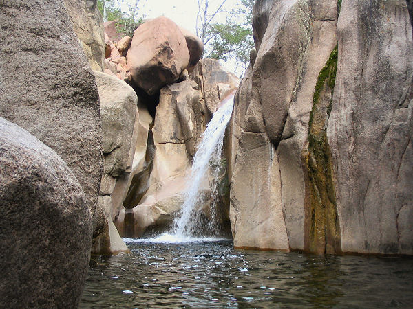 |
Narrows
near the Salome
confluence. |
|
|
