| |
Coon Creek Ruins - Sierra Ancha Wilderness, Tonto National Forest
| Summary: |
A short hike to some decent ruins.
Remember, ruins are fragile and irreplaceable, please leave the area as you
found it. It is also illegal to remove artifacts from
these historic sites. |
| Directions: |
From Phoenix
drive east on Highway 60 almost to Globe. Turn
left (north) on Highway 188 (also listed as 88
on maps) and drive 14.4 miles to Highway 288.
Turn right on 288 which soon crosses the Salt
River on a single lane bridge. After 6.7 miles,
turn right onto the well graded, dirt Cherry
Creek Road (which is also Forest Road 203).
Drive 7.8 miles to where the road crosses Dry
Creek marked with a sign. Continue 0.1 miles to
an unsigned dirt road on the left which climbs a
hill to pass beneath power lines. Those with
passenger cars should find a pull off on the
side of Cherry Creek Road. Those with high
clearance vehicles can follow the dirt road
(which is Forest Road 38) 1.7 miles to where it
splits. Park at the split. |
| Road
Conditions: |
Passenger Car / High Clearance Vehicle |
| Navigation: |
Easy |
| Length: |
8 miles if coming by passenger car, 4.5 miles with a high
clearance vehicle |
| Date
Hiked: |
April 2006 |
| Weather
Conditions: |
Hot and Sunny |
|
Required Skills: |
None |
| Hike
Description: |
Those with passenger cars will have to walk the 1.7 miles
on Forest Road 38 to the split described above. From the split turn right
onto FR 1076 (not signed) which drops down to cross a dry wash then climbs
steeply up a rocky hillside (it is not advisable to bring a vehicle up this
road). At the top of the hill the road bends left to parallel the drainage
of Coon Creek (which will be on the right), then climbs up and over a pass
which features the remains of an old camper top. Just on the other side of
the pass, prior to reaching a prominent wash, turn right onto a faint road.
The road soon becomes a path as it descends into the wash described earlier
to soon reach Coon Creek. Turn right and walk down Coon Creek on a use path
on the left, ducking under tree branches as you go. The path immediately
enters a wide box canyon. After 5 minutes look for a path which heads up the
hillside to the right to the ruins. If you pass all the way through the box
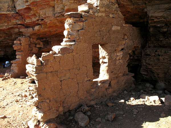
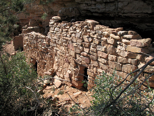
canyon, you've gone too far. The ruins feature several low buildings, some
of which have partial remains of roofs. When ready, return the way you came.
|
| Rating
(1-5 stars): |
 
The author drove along FR 38 to the junction with FR 1076 and completed the
4.5 mile hike in about 2 hours. |
|
Books: |
'Ruins
Seldom Seen' by Dave Wilson |
| Photos: |
Click picture for larger
view, click your browser's 'Back' button to return to this page. |
 |
 |
|
Coon Creek Ruins. |
|
|
