| |
Parker, Hog and First Water Canyons - Salome Wilderness, Tonto National Forest
| Summary: |
Three technical red
quartzite canyons with challenging climbs and terrific scenery. These canyons are all formed from water cutting through the same layer of rock. Parker is furthest up the hill and by far the largest drainage of the three. |
| Directions: |
From Phoenix
drive east on Highway 60 almost to Globe. Turn
left (north) on Highway 188 (also listed as 88
on maps) and drive 14.4 miles to Highway 288.
Turn right on 288 which is paved at first and
after a short distance crosses the Salt River on
a single lane bridge. After 12.2 miles you will
come to an intersection with left branching A
Cross Road [to park a car at the bottom of the
Parker Canyon drainage turn left on A Cross Road
and follow it 2 miles across private property
and turn right on Forest Road (FR) 213, follow this rough road 0.8 miles and park on the left at an overlook to the drainage]. Continuing on Highway 288, 2.7 miles from the A Cross Rd. junction you will cross the First Water Canyon Drainage, 3.4 miles from the A Cross Rd. junction you will the drainage of Hog Canyon on the left (there is a short road on the left to pull into if exploring this canyon), a short distance later you will see the large cliffs of Parker Canyon. To reach Parker drive 6.7 miles from the A Cross Rd. junction and turn left onto FR 488 (if you hit mile marker 278 you've gone too far). Drive about 3/4 of a mile on this moderately rough road to a spot with a pull off on the right and left sides near a drainage (left side has a fire ring), and park. |
| Road Conditions: |
High Clearance Vehicle: Lower drainage of Parker Canyon
Passenger Car: will get you close to all the upper parts of each canyon |
| Navigation: |
Moderate: some route finding in the lower section of Parker Canyon |
| Length: |
Parker ~5 miles, Hog Canyon ~1 mile, First Water Canyon ~1/2 mile |
| Date Hiked: |
January 2002 |
| Weather Conditions: |
Nice, highs in the upper 60's |
|
Required Skills: |


 |
| Hike Description: |
First Water Canyon:
This canyon is best done as a down and back trip. You will need
one rope (~100 ft), carabineer, harness, helmet and descending and ascending gear. Not much to this canyon. From 288, simply walk down the drainage. It's a little brushy, but gets deep and narrow fairly quickly. After 10 minutes you will come to a choke stone and dry fall of ~60 feet. There are some small but sturdy mesquite trees on the left side of the canyon to use as an anchor if you plan to rappel the drop off. A short distance below is another choke stone and drop of about 10 feet. Below that is a short stretch of narrows before the canyon opens up into the valley below. The author and his wife carried a 200 ft rope which easily reached down both drop offs. Return the way you came.
Hog Canyon:
This canyon is best done as a down and back trip. You will need one, maybe two ropes (~100 ft),
carabineer, harness, helmet and descending and ascending gear. The toughest part of this canyon is trying to find a way down into it. Once inside, it's not really that good, but here's the info if you want to try. There are two main drainages into Hog Canyon, the first (which begins right near the parking area) heads west, the other is further in and runs south. From the parking area walk northwest around the head of the first drainage, then walk west across a shallow wash which also feeds this first drainage. When you come to the south flowing drainage you will see that it consists of two parallel tributaries. Walk down the left tributary to a large drop off. You can climb down this drop off by backing up then walking along the ridge that separates the two tributaries. Walk down this divider a short distance to a point where you can climb down to the left to a prominent tree, then the rest of the way to the bottom (warning: this is a little tricky and the rock is loose). From this point you will be faced with ~60 ft drop off to the main canyon. There is a solid tree at the top of this drop off to use as an anchor. Once in the bottom, you will have to work your way through the brush to make progress down canyon. You will be faced with 3 down climbs to reach the end. The first two are fairly simple, the third requires some annoying bush wacking followed by some sketchy climbing over loose skree. There are no terribly pretty sections in this canyon, so my feeling is that it is not worth the effort. Return the way you came.
Parker Canyon: Note - an updated
description may be found in my
book.
This canyon
can be done as a through trip or down and back
trip. You will need at least one rope (~200 ft,
or a 100 ft rope and 100 ft pull cord)
carabineer, harness, helmet and descending and
ascending gear. At least one member of your
group should be a strong climber. From the
parking area, walk down the road to a point
where it forms a hair pin turn to the left
around a drainage. Leave the road at this point
and work your way down on the left side of the
drainage to a point where you can climb down
into the canyon next to an old
green gauge station. Below this the canyon
deepens quickly into an extremely pretty slot
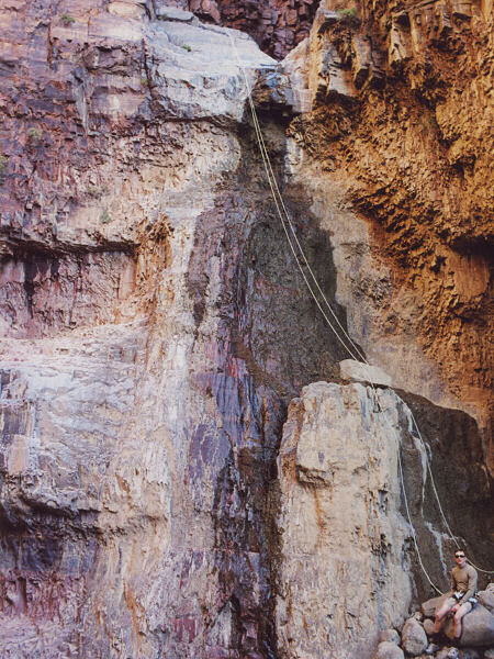
with red quartzite walls. Your first obstacle is a 15 ft dry fall.
The best climber should belay the group down
then climb carefully down afterwards. Below this falls are two more down climbs and possible pools to wade - be careful on the rock, it is as slick as ice when wet. The next obstacle is a choke stone and 20 ft chute. The chute is not terrible steep, but I recommend using the choke stone as an anchor and using a rope to hand line
or rappel down. Just beyond the choke stone is another drop forming a 30 ft slide. It is possible to climb down on the left hand side with some exposure
when the rock is dry, otherwise look for a
natural anchor just upstream (there are pinch
points among the rocks). It's easy walking for a while below this point as the canyon twists and turns through towering deep red rock pinnacles. Then you will reach a 50 ft dry fall with a large pool at it's base. There is a tree at the top of this fall if you'd like to rig a rope (then swim the pool), however, it is possible (though perhaps not recommended) to down climb on the right side if you don't mind the risk and exposure. Just past this point is an 80 foot dry fall. There
are two rusted pitons in a crack at the top of
the drop that may be used as an anchor. There is a huge boulder at the head of the falls sitting on top of smaller rocks. A better anchor than the pitons might be one of the
pinch points formed by smaller rocks wedged beneath the boulder. If you stay to the left side of the canyon during your rappel you can avoid the pool at the bottom of the falls. The canyon begins to open up after this point, but there are still a number of down climbs to negotiate. The next drop off (a 15 ft down climb followed by a 20 ft rappel) may be avoided by working your way around the breakdown on one side of the canyon or the other. You will have to do some boulder climbing before the canyon floor levels out in a riparian area that has been destroyed by cattle. Water begins to surface as you rock hop your way down stream, avoiding the thorny plants, hopping a few barbed wire fences, & sometimes walking more open areas along the bank. Eventually you will come to an area where the stream bed cuts through conglomerate rock forming a section of narrows. My recommendation is to head out of the canyon to the left before the slot becomes too deep and walk the bench above the narrows. The narrows are choked with cattails and deep pools which make for slow going (they are not very pretty either). If you walk to the left a ways you will pick up FR 213 which you can follow back to your car. |
| Rating (1-5 stars): |
 Parker Canyon Parker Canyon
Hog and First Water Canyons
In a trip to scope out some canyons, the author and his wife completed First Water Canyon and back in about 2 hours. At a later date the author returned alone (I do not set a good example, canyoneering alone is strongly discouraged!) and completed Parker Canyon as a through trip in 4 hours, then spent an hour exploring the lower narrows, which were not really worth it. I then went over to Hog Canyon and explored down to the valley and back in 2 1/2 hours. I carried one 200 ft rope for each of these canyons. |
| Maps: |
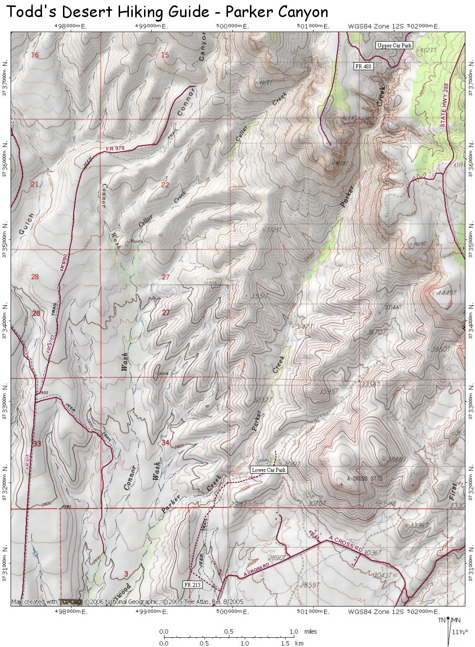
Click
here for a map of
Parker Canyon.
Tonto National Forest Map |
| Photos: |
Click picture for larger view, click your browser's 'Back' button to return to this page. |
 |
 |
 |
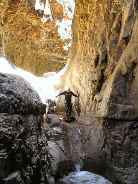
The
narrows of
Parker Canyon. |
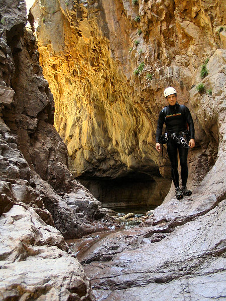
More narrows. |
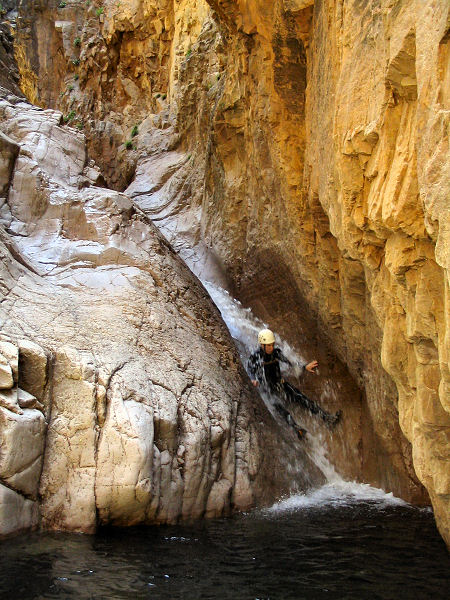
Water slide. |
 |
 |
|
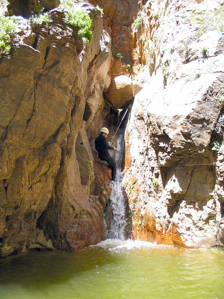
| Rappel. |
80' rappel. |
|
|
|
