| |
Esperero Canyon Loop - Santa Catalina
Mountains
| Summary: |
Nice hike up
(approximately 4300' elevation gain) and down canyons typical of this area.
Highlights include: Bridalveil Falls (if it's flowing) and Hutch's Pool, a good year round
swimming hole. |
| Directions: |
From I-10 take the Ina (pronounced eye-na)
Road exit #248 near Tucson. Turn east onto Ina Road and follow it as it
becomes Skyline Drive and then Sunrise Drive. After 14.5 miles, when you
reach the end of Sunrise Drive and a stop sign, turn left. The Sabino Canyon
Visitors Center and parking lot are immediately on your right. There is a $5
per car entry fee ($20 for an annual pass). |
| Road
Conditions: |
Passenger Car - paved all
the way |
| Navigation: |
Difficult - trail is
faint and overgrown in places |
| Length: |
16.8 or 20.8 miles loop
depending on whether you catch the shuttle at the road end or not |
| Date
Hiked: |
May, 1997 |
| Weather
Conditions: |
Too hot - 100 F |
|
Required Skills: |

 |
| Hike
Description: |
From the Sabino Canyon
Visitors Center (0.0 miles) walk up the paved road about 0.7 miles to the Cactus Picnic
Ground (0.7). From there you can pick up the Esperero Trail on the left side of the
road. The trail first gently winds through lowland desert, after 0.6 miles (1.3) you
reach a signed junction, continue left on the Esperero Trail, the right branch leads 0.4
miles back to the road and may be used as an alternate entrance into the canyon. The
trail then begins climbing steadily up a ridge. After an additional 3.5 miles (4.8)
the trail reaches a manzanita covered saddle with nice views up canyon (towards The Window
and the Cathedral Rocks) and back down the canyon you just hiked. Continuing
somewhat more gently uphill the canyon eventually drops down to follow the usually dry
stream bed where it becomes increasingly forested with white oak, chokecherry, Schott's
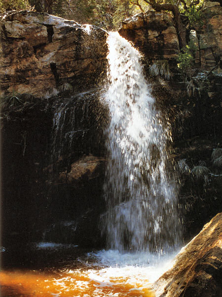
yuccas and Ponderosa pine. Continuing another 1.4 miles you will reach Bridalveil
Falls on your left (6.2), which you may walk right past if it's not flowing. It's
not particularly impressive, but waterfalls in Arizona are rare, so we'll take what we can
get. Leaving the falls behind, hike another 0.9 miles (7.1) to a signed junction
with the Cathedral Rock Trail. Turn right on this trail and climb steeply another
1.1 miles on a somewhat faint trail up towards a saddle (8.2). At the saddle the
trail becomes rather confusing and branches left and right, the left branch heads straight
up the ridge towards the Cathedral Rocks, the right branch is the continuation of the
Cathedral Rock Trail. Turn right and begin heading down through the brush.
This trail is quite faint and overgrown in this section, take your time (this is not a
good place to get lost). The trail eventually becomes more distinct and leads 1.1
miles to a signed junction with the West Fork Sabino Trail (9.3). Turn right at the
junction onto the West Fork Sabino Trail which winds gently down the forested canyon.
Eventually the trail climbs the side of the canyon as the stream drops away, the
forest cover thins and the trail increasingly grassy. After 3.4 miles you will reach
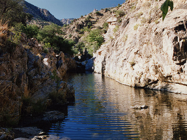
an unsigned side trail leading left down to Hutch's Pool (12.7). After checking out
the pool & possibly taking a dip, continue on the West Fork Trail another 1.6 miles to
a signed junction near Palisade Creek (14.3). Turn right at the junction onto the
Sabino Canyon Trail. The trail roughly parallels the creek which lies several
hundred feet below you to the right. Continue 2.0 miles to a signed junction with
the Phoneline Trail and a view of the Sabino Canyon Road end (16.3). Turn right
staying on the Sabino Canyon Trail and begin a 0.5 mile series of switchbacks down to the
road end (16.8). If you arrive in time you can take the shuttle back to your car at
the visitors center, otherwise you'll have an additional 4 mile road walk (20.8). |
| Rating
(1-5 stars): |

This was one of the first hikes I did after moving to Arizona, and as a
novice desert hiker made several avoidable mistakes. I did not carry a map (relying
solely on the guidebook listed below), I did not carry enough water, and I hiked in
temperatures which exceeded 100 F (errors I have not repeated since). The end result
was that I got turned around, ended up hiking an additional 3 miles and wound up severely
dehydrated. On the positive side, this is a nice remote walk for the experienced
desert hiker which loops through several ecological zones (plus has a swimming hole to
cool tired feet). The last shuttle leaves the Sabino Canyon road end around 4:30pm
(check at the visitors center for exact times), so unless you start very early or hike
very fast plan on a 21 mile day. |
| Maps: |
Santa Catalina Mountains
- Rainbow Expeditions Inc. |
| Books: |
'Arizona Trails - 100
Hikes in Canyon and Sierra' by David Mazel |
| Photos: |
Click picture for larger
view, click your browser's 'Back' button to return to this page. |
 |
 |
| Hutch's Pool |
Bridalveil Falls |
|
|
