| |
Jacks Canyon / Hot Loop - Sedona
| Summary: |
A long loop hike near the
village of Oak Creek along the Jacks Canyon and Hot Loop Trails. The hike is
described in a clockwise direction (in other words, going up Jacks Canyon
and down the Hot Loop Trail, for those more familiar with digital time
pieces). |
| Directions: |
From Phoenix take I-17 north,
to exit 278 for Highway 179. Turn left off the exit ramp and drive west
along 179 into the Village of Oak Creek. You can pick up a Red Rock Pass at
the rangers station on the west (left) side of the road just before the
second set of traffic lights. At the second traffic light, turn right onto
Jacks Canyon Road. Drive 3.1 miles (note: the road makes an abrupt right
hand turn after 0.9 miles) and look for a trailhead sign and short spur road
on the right (the sign is somewhat obscured by a bush, but is directly
opposite Canyon Ridge Trail Rd.). Turn right onto this dirt road and drive
0.1 miles to the large parking lot and trailhead. |
| Road
Conditions: |
Passenger Car |
| Navigation: |
Difficult - for the loop, navigation would be
easy for a short out and back hike on either trail |
| Length: |
17.8 miles |
| Date
Hiked: |
October 2005 |
| Weather
Conditions: |
Clouds and Sun |
|
Required Skills: |

 |
| Hike
Description: |
From the trailhead (0 miles,
4300 ft), walk through the gate to the left of the trail sign onto Jacks
Canyon Trail #55. The path is sandy, flat and braided in places as it winds
its way next to a road and then behind a number of houses that dot the area.
After about 30 minutes of walking, you'll leave the houses behind and the
trail becomes more distinct as it heads up the floor of the canyon at a
comfortable grade, eventually passing a stock pond and wilderness boundary
sign. In time, the trail becomes more forested with pinyon and juniper trees
as it travels beside a dry wash, crossing it from time to time. |
| |
Note: The trail remains within a stone's
throw of the wash right up until you reach the head of the canyon. If you
find yourself climbing the steep hillside up and out of the canyon on one
side or the other, you are off the trail. There are several of these false
paths along the route, and some of them are marked with cairns. |
|
| Finally, at the head of the
canyon, the trail leaves the dry wash to the right and climbs steeply up
along an eroded path to a saddle and a trail junction (6.6 miles, 6400 ft).
The Munds Mountain Trail #77 branches left, there appears to be a trail that
heads straight, and the Schnebly Trail #158 heads right (though there is no
sign post). |
| |
Note: Years ago I climbed the trail to Munds Mountain. I
recall it as being a steep climb and that the top featured many cow patties
and no views. |
|
| Stay right on the Schnebly
Trail #158 as it climbs along the ridge (you'll soon pass a sign verifying
that you are on #158). The path soon tops out on a grassy juniper dotted
mesa and you'll have views to the left of a few red rock formations. |
| |
Note: The map, referenced below, shows that the Schnebly
Hill Trail ends at a stock pond and dirt road. This is not the case. The
Schnebly Hill trail passes the stock pond and continues north. This trail is
not shown entirely on the map. Do not remain on the Schnebly Hill trail past
the stock pond (see below). |
|
| A short distance along the Schnebly Hill
Trail, you will pass by a stock pond (Committee Tank) which will be on the
right. Leave the trail at this point and walk around the tank and through a
break in the fence flanked by large posts which form a doorway (very easily
seen from the trail). Continue circling the tank to the right until you spot
a dirt road. Turn left and begin following the road. After 5 minutes the
road splits (stay right) and heads south, eventually bending around in a
more northerly direction. Stay right again where another road enters from
the left and 5 minutes later turn right again at a 'T' junction next to a
stock pond (Oak Tank). Follow this road for 1.5 miles as it heads due south.
Eventually you'll have views south into the large drainage of Woods Canyon.
When the road begins to bend to the right, look for a cairn and sign on the
left for the Hot Loop Trail #94 (9.8 miles, 6300 ft). Turn left onto
the Hot Loop Trail which is grassy and disused as it heads towards the
canyon rim. As it begins its switchback descent, the path becomes severely
overgrown with scrub oak and is very unpleasant. When you reach an area that
consists predominantly of manzanita, the brush fades and the walking becomes
easier. Keep your eyes open as the path descends towards Horse Mesa, the
area is fairly open and the track is rather faint. There are a few cairns in
the area to assist with navigation. Eventually the path levels out on the
grassy, basalt covered plateau of Horse Mesa. You now have several miles of
dull, rocky slogging ahead. Again, stay alert, since the trail is extremely
faint in places. Along the way there will be a few views into Woods Canyon
to the left, and later of Jacks Canyon to the right. In time, the path
becomes dirt and is easier to follow as it descends gradually to the
southwest. Finally, the path begins descending from the mesa next to a minor
'V' shaped drainage. As you descend, look for a cairn and trail that
branches back to the right. You'll know you have missed this junction if the
dirt under your feet turns from brown to red. Turn right onto this right
branching trail (16.6 miles, 4700 ft) as it winds around the drainage you
have been following above the Supai. It then climbs a short distance to a
saddle then begins descending down the other side towards a sea of roof
tops. When you reach the bottom of the hill, stay to the right and head
towards the large corral which marks the parking lot and trailhead (17.8
miles, 4300 ft). |
| Rating
(1-5 stars): |
 
The author completed the hike in 9 hours at a quick pace, but lost the
path in several spots. In Jacks Canyon I followed a well defined and cairned
trail that climbed up and out of the canyon on the right. Eventually the
trail faded and I returned to the canyon bottom. At the top of Jacks Canyon
I stayed on the Schnebly Trail instead of leaving the trail to pick up the
forest road and had to retrace my steps. Later I walked right by the trail
junction for the path that leads from the Hot Loop Trail back to the parking
lot. I realized my mistake a mile later when I arrived at the next trail
junction for Woods Canyon. Hopefully, by following the directions above
closely, you can eliminate these errors. |
| Maps: |
Bear Tooth Maps: Sedona |
| Books: |
None used |
| Photos: |
Click picture for larger
view, click your browser's 'Back' button to return to this page. |
 |
 |
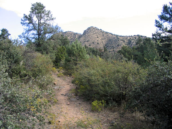
| Typical scene
in Jacks Canyon. |
Jacks Canyon. |
 |
 |
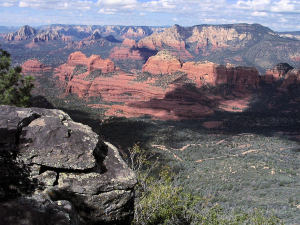
| Red rock view. |
Mesa above Jacks Canyon. |
|
|
