| |
National Trail - South Mountain
Park
| Summary: |
A hike along the ridgeline of
South Mountain Park in south Phoenix. To
complete this hike you'll need to spot a car at
each trail head. The trail is designated as a
multiple use path, which means it is open to
mountain bikes and horses. It's the bikes that
are the real annoyance, but you'll find they are
not present west of the Buena Vista parking
area. |
| Directions: |
West Trailhead: Take Baseline
Road to Central Ave. Go south on Central to the
main entrance of South Mountain Park. Follow the
signs for San Juan six miles to the parking area
at the end of the road.
East Trailhead: Drive back to Baseline Road and
head east. Turn south on 48th Street. Take the
second right out of the traffic circle and
follow the road as it curves east, then
south, to Guadalupe Road. Go west about 1/4
mile, turn north on 48th St. then almost
immediately turn left onto Pima Canyon Road.
Drive to the end of the road and park (unless
the lot is full, in which case you'll have to
find a spot on the side of the road). |
| Road Conditions: |
Passenger Car - paved all the
way |
| Navigation: |
Easy - well marked
trails throughout |
| Length: |
15 miles |
| Date Hiked: |
December 2003 |
| Weather Conditions: |
Cool and cloudy with
occasional sprinkles |
|
Required Skills: |
None |
| Hike Description: |
I describe this hike heading
east to west. From the parking area at the end
of Pima Canyon Road, follow the wide, flat dirt
road west (with the mountain bikers, joggers and
dog walkers) just over a mile as it follows the
shallow drainage of Pima Wash. Turn left onto
the National Trail, which begins just past a
large sign. The trail immediately begins
climbing moderately up to the ridge line. As you
reach the top look for the left branching Hidden
Valley Trail. Turn left on this short detour
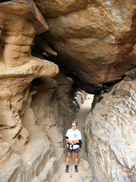
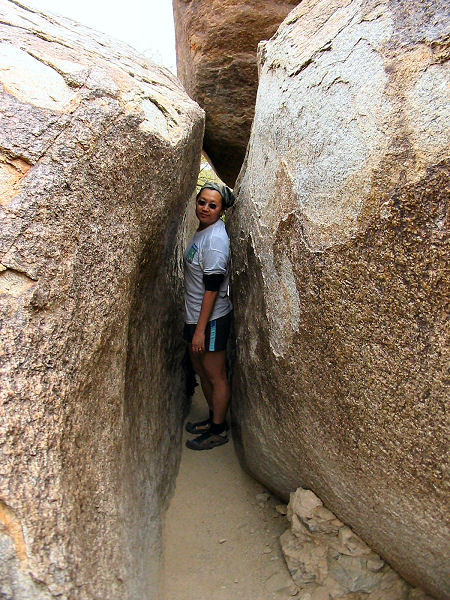
which passes through the rock formations of the
Tunnel and Fat Mans Pass before rejoining the
National Trail a short distance later (probably
the best part of the hike). Continue traveling
along the ridge as the path winds its way
through the rocks. After passing sign post #19
(I'm not sure if the numbers on the posts have
any significance or not), the path rounds a bend
and drops down to the Buena Vista parking area.
The trail picks up on the other side of the lot
and the parallels the road towards the prominent
antenna array on the peak ahead. Typical plants
in the area are: palo verde, saguaro,
brittlebush, mesquite, ocotillo, barrel cactus,
jointed fir and hedgehog cactus. The trail
passes below the antenna array on the northern
slope, then descends gradually towards Telegraph
Pass. Walk up the road a short ways, then follow
the trail as it climbs up moderately to gain the
ridge once again. Once on the ridge you'll have
views north of downtown Phoenix and south of
houses and the Gila Indian lands. As you reach
the top, the walking becomes easier as the path
travels along the ridge, passing a few old mines
as it does so. The smoother rolling hills of the
western section of the trail are quite distinct
from the rocky eastern section. Eventually,
you'll be able to see the San Juan Road in the
valley to the north that you drove on earlier
when you spotted a car. The path soon begins
descending, gradually at first, then more
steeply towards the end as it travels down into
a gully. At the bottom of the gully the trail
turns abruptly right, crosses the wash and
climbs over a low hill before dropping into the
creosote flats below. Once in the bajada, the
trail heads east, crosses the road, then bends
northwest, eventually paralleling the road until
it brings you back to the trailhead and your car
spot. |
| Rating (1-5 stars): |
 
A pretty good hike considering it's in the
midst of the 6th largest city in the country.
The author and his wife completed this hike at a
moderate pace in 6 hours. |
| Maps: |
None |
| Photos: |
Click picture for larger view, click your browser's 'Back' button to return to this page. |
|
|