| |
Cibeque Creek - White Mountain
Apache Reservation
| Summary: |
Two hikes are
described here.
Hike #1: A short out
and back hike through a nice canyon to a
waterfall. This is a hike you could take the
whole family on, but be prepared to get your
feet wet. Note: a permit from the Apache Tribe
is required for this hike.
Hike #2: A technical through trip down
Tank Canyon to Cibeque. A permit and Apache
guide are required. Contact information is
provided below. |
| Directions: |
From Phoenix,
head east on highway 60 to Globe. Turn north
(left) on highway 60/77 ~20 miles to where the
highway drops down and crosses the Salt River.
Just past the bridge on the right hand side is
a small store where you can obtain your permit
($10 per person for Hike #1, $15 per person
for Hike #2).
Hike #1: Drive across the road and
follow the well graded dirt road 4 miles to
the trailhead. Note: about 100 yards before
the trailhead you will have to drive across
Cibeque Creek. If the water level is high you
may want to park and walk across.
Hike #2: You will need to arrange a meeting
location with your guide; this is most likely
going to be the same small store where you
purchase your permit. |
| Road Conditions: |
Hike #1: Passenger Car
- well graded dirt road the last 4 miles (be
careful if you are driving across the stream).
Hike #2: Four Wheel Drive |
| Navigation: |
Easy |
| Length: |
Hike #1: 3 miles (1.5
miles each way)
Hike #2: ~7 miles |
| Date Hiked: |
Sept &
Oct 2001 |
| Weather Conditions: |
Warm |
|
Required Skills: |


 |
| Hike Description: |
Hike #1:
From the
parking lot, simply walk up stream. This is a
frequently visited canyon, so a use trail has
developed on one side of the stream or the
other. You will have to cross the creek
several times, so don't bother trying to keep
your feet dry. The lower parts of the canyon
are mainly composed of volcanic rock. It is
rather wide at first, but becomes more narrow
and picturesque as you head upstream. After
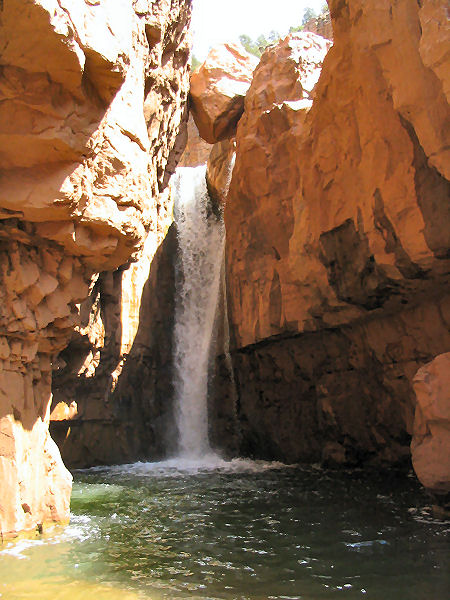
~20min you will pass a gauging station,
another 40 minutes will bring you to a large
waterfall and a couple dripping grottos.
Unfortunately, this is your turn around point.
The Apache Tribe does not allow anyone to proceed
beyond this falls without an Apache guide.
Return the way you came.
Hike #2: A rough drive is required to
get to the head of Tank Canyon. You will have
to drive your own car, however, the guide will
provide drivers to bring your car around to
the bottom of Cibeque Canyon so that it is
waiting for you at the end of your trip. From
the head of Tank Canyon, you simply walk down
stream. The upper part of this canyon is wide
and not terribly interesting. After a few
hours the canyon eventually cuts deeply into
the sandstone, forming some nice sections of
narrows. The last mile before you reach
Cibeque you run into the technical section
which requires 4-5 rappels of 40-115 ft and a
few short pot hole swims (your guide will help
rig this section). Tank Canyon dumps you out
into a very pretty section of Cibeque (just
below the 3rd falls). Heading down stream, the
canyon widens, then narrows to the second
falls. You could climb around this obstacle on
canyon left, however, the guide can rig a
guided rappel which makes for a much more
interesting way down through the falls itself.
On the other side of the falls a short swim is
required through a very narrow section of
canyon, then it's more hiking and wading to
the first falls (your turn around point for
Hike #1) and your last rappel. An hours walk
down stream brings you to the exit point and
your waiting car. |
| Rating (1-5 stars): |
Hike #1
It took the author and his wife about 1 hour
each way to complete this hike. We hiked it as
part of a canyoneering class, practicing
rappel and anchor techniques at the falls. Due
to a recent rain storm the water was heavily
silted and brown (supposedly it is a beautiful
blue/green color during dryer
weather).
Hike #2
The author and
his wife completed this hike as part of a
group of 8. The lower section of Tank Canyon
and the trip through Cibeque were very scenic
and fun. A smaller group would probably
eliminate some of the clogging at rappel
points. Eight hours of walking was required to
complete this trip.
You can
contact Greg (a licensed Apache guide) at the
following numbers.
White Mountain Apache
Wildlife and Outdoor Recreation Division:
928-338-4385
Greg: 928-242-0029,
[email protected] |
| Books: |
Canyoneering Arizona', Tyler Williams |
| Photos: |
Click picture for larger view, click your browser's 'Back' button to return to this page. |
 |
 |
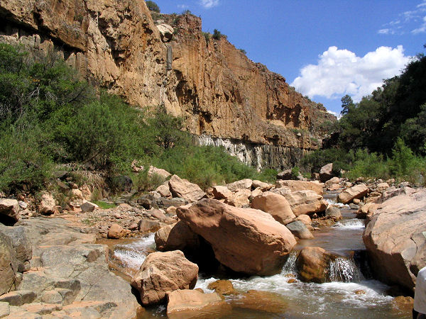
A
typical view on the way to the
waterfall in lower Cibeque. |
The 1'st waterfall. |
|
|
