| |
Eagletail Mountains Wilderness
- Ben Avery Trail (north)
| Summary: |
The Eagletail Mountains
Wilderness (which was created with the adoption
of the Arizona Desert Wilderness Act of 1990) is located just south of I-10 about
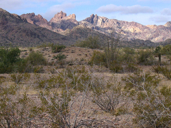
50 miles west of Phoenix. The 15 mile range of
the Eagletail Mountains (the remnant of a
volcanic dike that formed nearly 20 million
years ago) form the northern boundary to the
wilderness, while the southern portion consists
mainly of open desert and washes. Trails are
faint to non-existent in the area and water is
scarce. Map, compass and maybe a gps are
necessary
for cross country travel. A hike from the
northern Ben Avery Trailhead to the Indian
Springs area and beyond is described. |
| Directions: |
Courthouse Rock Trailhead: From Phoenix, drive
west on
I-10 to exit 81 (Harquahala Valley Road & Salome
Road). From the exit ramp turn left (south),
drive across the bridge over I-10 and turn right
onto Harquahala Valley Rd. After 5.3 miles turn
right onto Courthouse/Centennial Rd (which is well graded
dirt). After 6.9 miles you'll hit a fork in the
road with a sign for the Eagletail Wilderness on
to the left. Stay right at this junction on a
natural gas pipeline maintenance road (which is
somewhat rougher dirt). Drive 4 miles, ignoring
any roads which branch to the left, until you
see another wilderness sign on the left. Turn
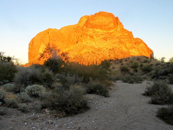
left on this road towards the obvious formation
of Courthouse Rock and drive 1.5 miles to a
parking area and kiosk (this road has one rocky
section which would likely prove difficult for a
passenger car). |
| Road Conditions: |
High Clearance Vehicle |
| Navigation: |
Moderate to Difficult |
| Length: |
5 miles roundtrip to the
petroglyphs, however you can extend the hike as
long as you'd like |
| Date Hiked: |
January 2004 |
| Weather Conditions: |
Partly cloudy and cool |
|
Required Skills: |
 |
| Hike Description: |
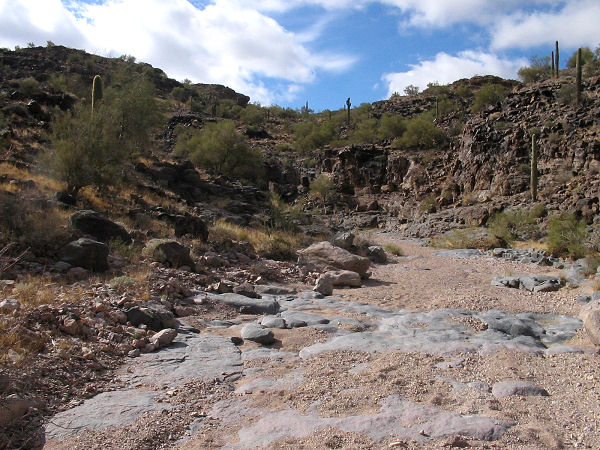
From the kiosk, walk south
through the fence and follow an old jeep road
that winds its way around the west side of
Courthouse Rock. After 15 minutes or so the path
enters a wide and sandy wash which you will
follow for another 15 minutes or so. Along the
way you'll cross a fence; where the wash
narrows, look for a jeep road which exits the
wash on the left hand side. Follow the road as
it heads west, then turns south to parallel a
cliff band, winding its way in and out of a few
minor drainages as it does so. After about 20
minutes of walking on the road, the path crosses
a very wide wash then follows this wash along
the left side. After about 10 minutes of walking
look for a small, dark mesa on the left that
sits by itself apart from the other basalt
cliffs in the area. The mesa resides in the
Indian Spring area of the Wilderness, which
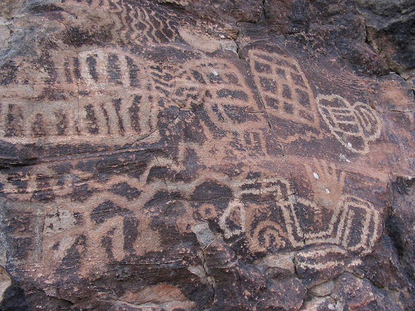
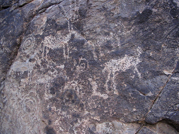
contains evidence of some of the earliest Native
American occupation in the southwest. The most
noticeable of which are the many petroglyphs
that cover the rocks on this mesa. The area is
believed to have been an important cultural and
ceremonial site dating back to about 1500 BC.
You will see two distinct styles of petroglyphs
on the rocks. The oldest are approximately 3500
years old and were made in the Western Archaic
style - identified by rectilinear designs such
as grids, ladders, zigzags beehives and bulls'
eyes (these are most prevalent in the area). The
more recent were made in the Gila style, which
is common to the Hohokam and peoples after 500
AD. These include abstract curvilinear designs
and human and animal forms (and are much more
interesting in my opinion). You'll also see some
graffiti (one dated back to 1903), but most of
it does not appear to be very recent. Please
preserve the area by leaving it as you found it.
If you decide to continue on, the Ben Avery
Trail bends left around this basalt mesa and
follows the wash as it travels between basalt
cliff bands. If you have good eyes, you might
spot additional petroglyphs on the rocks on
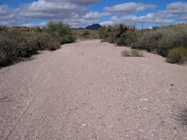
either side of the wash. As you continue down
the wash, the cliff bands slowly give way to
rolling hills, then to wide open desert. The
'trail' follows the wash south, but there is no
marked path and the open desert really doesn't
make for a very interesting hike. You'll need a
map, compass & maybe gps if you plan to
negotiate the trail any further. When ready,
return the way you came. |
| Rating (1-5 stars): |
  to
the end of Indian Spring wash and back to
the end of Indian Spring wash and back
the
rest of the Ben Avery Trail
The author and his wife hiked to the
petroglyphs at a brisk pace in about an hour. I
then had the brilliant idea to hike the
remainder of the Ben Avery trail, while my wife
drove around and picked me up. Unfortunately I
did not count on the facts that: 1) the trail
was non-existent, 2) the other trailheads in the
Wilderness are difficult to reach and not
marked. I followed the wash south about 10 miles
to within a mile of Nottbusch Butte when I hit
my bail out time. I realized I needed to be
further east, but without a map, did not have a
clear idea of where the trail should be. To be
safe, I retraced my steps (for a total of a 20
mile hike), reaching the Courthouse Rock
Trailhead at sunset. Unfortunately, my wife was
still looking for me at the other trailheads
(not sure that she had located the correct one),
so I hiked another 6 miles along the road until
I was picked up by a fellow hiker who my wife
had enlisted to find me (Paul and son from
Glendale - many thanks!). If I stress carrying:
map, compass & gps several times in the above
description, now you know why. |
| Maps: |
A map of a portion of this hike can be found
here - 399KB. |
| Books: |
Exploring Arizona Wild
Areas - Scott
S. Warren |
| Photos: |
Click picture for larger view, click your browser's 'Back' button to return to this page. |
|
|
