| |
Havasu Canyon - Havasupai Nation & Grand Canyon National Park
| Summary: |
A rather mediocre hike to a spectacular
creek and waterfalls. Most people complete this hike as a backpacking
trip, staying at least one night in the canyon. The agenda described below
is for three days: Day 1: down to the campground; Day 2: explore
downstream and the falls; Day 3: hike out. Lots of logistics to contend
with:
Reservations: to camp in the canyon you need to make reservations
ahead of time by calling one of the following numbers (all are area code
520): 448-2121, 448-2141 or 448-2237. If you would rather stay at the
lodge call: 448-2111 or 448-2201 or FAX request to: 448-2348.
Fees (as of this writing): Entrance fee = $20 per person per visit,
Camping fee = $10 per person per night, Mule ride (bring a respirator or
dust mask) = $75 one way or $150 round trip (add 5% tax for all fees) |
| Directions: |
From
Flagstaff drive west on I-40. Take the exit for Seligman (last chance to
get gas & supplies) and head west on Route 66. Turn right on Indian
Road 18 and drive 60 miles to where it ends at Hualapai Hilltop. |
| Road
Conditions: |
Passenger Car - paved all the way |
| Navigation: |
Easy |
| Length: |
10 miles from Hualapai Hilltop to the
campground
9 miles round trip from the campground to Beaver Falls
16 miles round trip from the campground to the Colorado River |
| Date
Hiked: |
November, 2001 |
| Weather
Conditions: |
Nice |
|
Required Skills: |


 |
| Hike
Description: |
Day 1: Hualapai Hilltop to the
Havasu Campground
From the parking lot head north and follow the horse trail down a
series of fairly steep switchbacks. Mule and horse trains use the trail
daily, and as a result, the earth has been pounded into a soft powder that
becomes airborne at the slightest provocation. Breathing through a bandana
when horses pass might help filter some of the particles before they reach
your lungs. Those riding horses better pray for a stiff breeze or be
carrying a respirator. Horses are also responsible for the barnyard odor
that will accompany your entire hike. In one section in the lower canyon,
where the sandstone contains potholes, equine excrement has formed pools
of raw sewage rank enough to turn your stomach. The first mile and 1/2 of
the trail descends rapidly on a rocky, dusty path through the Coconino
Sandstone. The trail then levels out somewhat at the Hermit Shale layer
before dropping into the main drainage of Haulapai Canyon (1.5 miles). A
sign at the entrance to the canyons warns the hiker of flash flood dangers
within the canyon. Once in Haulapai Canyon the trail becomes a level
gravel path as it winds its way through the canyon for the next 4 1/2
miles. You then come to the junction with Havasu Canyon which enters from
the right (6.0 miles). Stay left and head down Havasu Canyon passing by a
coral, then follow the sign for Havasu Campground right across a wooden
bridge. Here you will catch your first glimpse of Havasu Creek and the
blue/green water which makes the area notable. Shortly afterward, you will
enter Supai Village, a small Indian town with a few tourist amenities (8
miles). You will pass the Sinyella House - a small grocery store with
soda, candy, cameras, film, ice cream, gatorade, water, coffee, socks
& T-shirts. Stay to the right as you pass through the town on the
sandy road. Check in at the visitor center (small brown building on the
left) if it is open. When you reach the cafe (cash only, serves breakfast,
lunch and dinner daily) turn left and left again when you hit the church.
From then on stay to the right following the Havasu Campground signs until
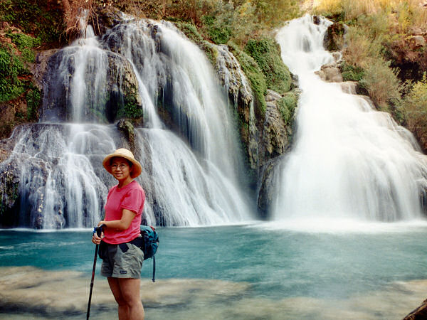
you are out of town. On your way down to camp you will pass 75 ft tall
Navajo Falls (on the left). You can see the falls from the road, but
because they are surrounded by trees you will need to work your way down
through the brush to get a good view (very much worth the trip). Further
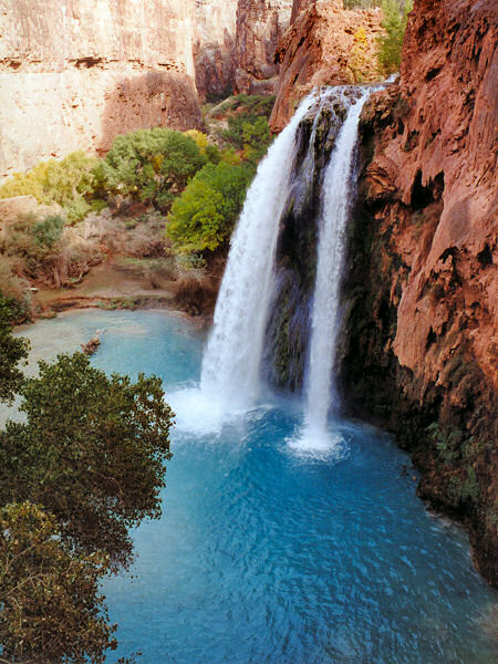
along you will pass by 100 ft tall Havasu Falls, one of the most
photographed waterfalls on the planet (and for good reason), with a great
view from the road as you descend. Shortly thereafter, you will reach a
gate (horses prohibited past this point, thank goodness) beyond which is
Havasu Campground (10 miles). The campground is surprisingly nice for such
a well used place and you may camp at any unoccupied site you choose.
Spring water is available from a small shed located on the left in the
upper part of the camp. Toilets (stinky and ill maintained) are located on
either end of the camp. I highly recommend using one of the poles located
in each camp to hang your food at night - our camp was visited nightly by
a large raccoon that rifled our packs, opening zippers and looking into
pockets for a free meal.
Day 2: Havasu Campground to
Beaver Falls
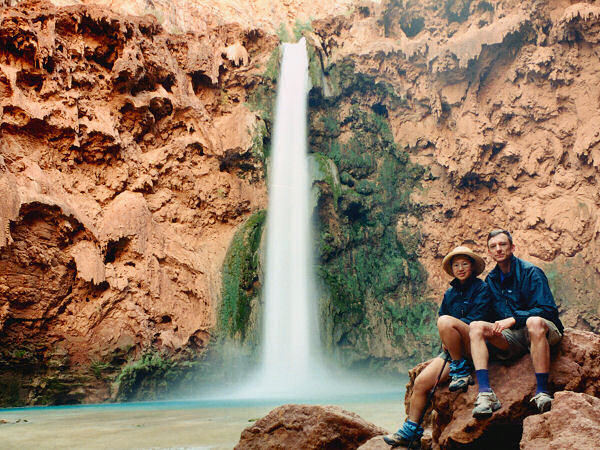
Walking down stream from the campground, you will soon arrive at Mooney
Falls, another spectacular falls dropping 200 feet from a sheer cliff into
a large blue/green swimming pool below. To descend to the base of the
falls you will pass through two short tunnels and use a series of chains
and ladders to negotiate the steep face of the travertine covered cliff
(the lower section of this climb may be wet and slippery from the mist
from the falls). At the base of the falls a use trail begins on the left
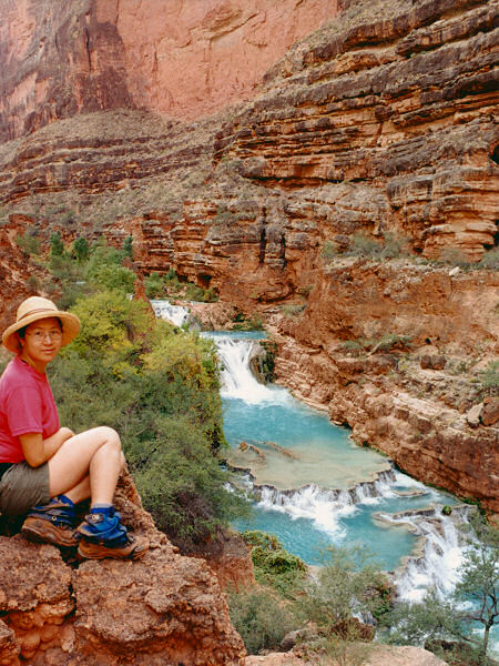
hand side of the stream heading down canyon. To get to Beaver Falls,
follow the well developed trail down stream through the riparian
vegetation. Along the way you will have to cross the stream three times.
The stream bed is rocky, so it's best to leave your shoes on and suffer
getting them wet. You will pass numerous rim stone dams which create
small, interesting cascades along the stream. These limestone falls are
formed from fallen branches or rocks that become coated over time with
dissolved lime in the water. The lime is also what gives the water its
unique blue color. Just before reaching Beaver Falls the trail will stop
at a small rock face with ropes in place on the right. Using the ropes,
climb up the trail to a ledge which follows the stream from high on the
right hand wall. Beaver Falls is located just upstream of Beaver Canyon
(which enters from the left). The falls is of moderate size and is spread
out over a series of cascades which makes getting a good photo difficult.
Because the trail travels high above the water line at this point you will
have to backtrack once the trail drops down to stream level again if you
want a closer view of the falls. Return the way you came, or continue
following the trail downstream to the Colorado River.
Day 3: Hike out retracing your
steps of Day 1.
|
| Rating
(1-5 stars): |
 - Haulapai
Hilltop to Havasu Campground - Haulapai
Hilltop to Havasu Campground
 - Havasu Creek and waterfalls
The author and his wife got a rather late start, due to the long
drive, and hiked down to Havasu Camp in 3 hours 45 minutes, arriving just
before dark. On day two we headed downstream along Havasu Creek to Beaver
Falls and back (a leisurely 6 hour round trip), then went upstream to
explore and photograph the other falls. The next day we got an early start
and hiked out in 4 hours 15 minutes. |
| Maps: |
Trails Illustrated -
Grand Canyon National Park |
| Books: |
Canyon
Hiking Guide to the Colorado Plateau -
Michael Kelsey |
| Photos: |
Click picture for larger
view, click your browser's 'Back' button to return to this page. |
 |
 |
| Navajo Falls. |
Havasu Falls. |
 |
 |
| Mooney Falls. |
Beaver Falls. |
|
|
