| Directions: |
From Flagstaff follow US 180 northwest until you reach the cheesy Flintstone town of Bedrock. Turn north (right) onto Highway 64 (which is also 180) to the south entrance of the Grand Canyon.
Drive into the park and follow the signs towards the Grand Canyon Village. Follow the main road past the Bright Angel Lodge until you reach Maswik Lodge. Turn right after passing the lodge and drive around back to a paved road which leads to the kennels. Follow the signs to the kennels, but drive past it until you cross the railroad tracks, turn left onto Rowe Well Road. After a short distance the road becomes dirt (or mud, it is highly reccomended that you have a 4-wheel drive vehicle to proceed on this road, it may look easy enough when dry, but after a rain it becomes a treacherous mud wallow). Turn left on Rowe Well Road and drive south for approximately 3 miles to the park boundary. You are now in the Kaibab National Forest and on FS road #328A. Continue on 328A for approximately one mile to FS #328. Turn right at the intersection. There is a sign indicating Tusayan (6 miles) to the left and Pasture Wash to the right. Turn right and continue west on #328 for approximately 15.6 miles to the Havasupai Nation's boundary (there is a cattle gaurd and 'No Trespassing' sign posted here). Supposedly the boundary is sometimes staffed by Havasupai rangers who will gouge you $25 to drive through their land (there are several closed roads to Pasture Wash that do not pass through indian land, the Park Service should re-open these roads so hikers are not subjected to this nonsense). If no ranger is present, there's nothing stopping you from proceeding ahead. Once inside the reservation, continue approximately 1.7 miles to an unmarked fork. A short distance down the right fork two upright posts are visible. Take the right fork, but do not drive through the posts, instead take a 90 degree right just before them heading north. After driving 1.9 miles you will reach the boundary with the Kaibab Forest again, another 1/2 mile will bring you to the park boundary (marked with a cattle gaurd and gate - please close the poorly constructed gate behind you). Two more miles brings you to the old, boarded up Pasture Wash Ranger Station - you can park here and walk the remaining 3.6 miles to the trail head if the road is deep mud, or continue on to the South Bass Trailhead and park. |
| Hike Description: |
The author and his wife performed this hike as a 4 day backpacking trip and I will describe the hike accordingly. Others may prefer a slower or faster hike. Note: this trip requires quite a bit of climbing as well as a short rappel (a 50' rope and 20' of webbing are required).
Day 1 -
South Bass Trailhead to head of Royal Arch
Canyon: Follow the South Bass Trail down
into the Canyon. The trail is easy to
follow as it descends to the east through
the upper portion of the canyon (Indian
ruins may be seen on the canyon walls to the
right as you descend) towards the major
drainage ahead. The trail heads steeply down
the drainage to the Esplanade (as evidenced
by the red rocky sandstone) the trail
becomes less distinct, but cairns mark the
way. When you reach the distinct fork in the
trail, head west (left). The trail along the
Esplanade is mostly easy to follow and is
marked by cairns at moderate intervals. The
trail becomes more faint where rock fall
from the yellow Coconino sandstone covers
the route. The second major drainage
encountered along this route contains Seep
Spring. When the author was here, water was
flowing across the Esplanade, however,
usually you will have to walk up the
drainage to find it. Continuing on, there
are some good campsites where the trail
rounds Montezuma Point. After passing the
point you will come to the first of three
main drainages down into the main canyon of
Royal Arch Creek- the author traveled down
the eastern drainage (the first one you come
to). The author continued a short distance
past Montezuma Point to the head of Royal
Arch Creek and camped at a small but flat
spot in the drainage. Note: there was water
in the drainage when the author was here
(after several rainy days), but usually this
section of the route is dry. This portion of
the hike was completed in 5 hours.
Day 2 - East fork of Royal Arch Creek to the Colorado River at the Toltec drainage: There is no real trail for the majority of this section (a few cairns every now and then), however, you can't get lost since you just follow the stream bed. Do not expect to make quick time through this section, the rocks and climbing involved make for slow going. Heading down stream, you'll come to a drop off a short distance into the hike. This may be passed by following a cairned route on the right hand side. The canyon becomes deeper as
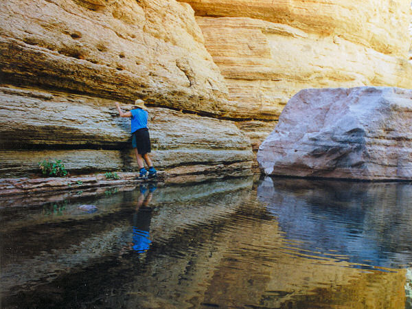
you rock hop your way down stream past the entry point of the second fork. Shortly before reaching the third fork you'll reach a large drop off and your first exciting climb. According to the Forest Service "This can be passed on the left side via a trail with some exposed climbing. A fall here could result in serious injury or death." Follow the cairns along the left side of the drainage until the trail seems to disappear. The climb described is really a traverse of 10-15 ft along a 4" ledge, one for your toes and one for your fingers (how convenient!). The traverse is not really difficult technically, however, the fact that you'll die if you slip will probably get your heart racing a little (especially with the weight of your pack pulling you back from your little
perch). Take a deep breath, make sure you have a good grip & scoot along (the author went across 3x bringing both his & his wife's pack across, unfortunately thoughts of survival dominated & I forgot to take pictures - I've been kicking myself since). There are a couple shorter traverses after that, then you'll have to route find down a scree slope back to the relative safety of the canyon bottom. Note: shortly down canyon a cairned path was observed leading up to the right side of the canyon - there may be another way around the falls on the right hand side which avoids the scary traverse(?). After reaching the 3rd arm of the creek the canyon becomes quite deep (it took the author 2 hours to reach this point from the east fork). A dry fall is encountered a short distance later, this may be down climbed on the right side by handing down packs. Lower in the drainage you may encounter two deep pools. You may be able to wade or swim the pools (if you don't mind getting all your gear wet and becoming hypothermic), a better idea would be to climb up and around to the left, it may not look like you can get down to the creek bed again, but it's actually not that tough. Further down canyon you will encounter cairns leading up the east
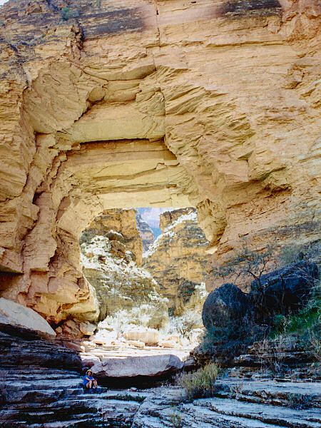
(right) side of the drainage. Here you'll want to drop your packs (except for your camera & maybe some water) and continue down canyon 0.5 miles to Royal Arch (some climbing may be involved to keep your feet dry in this section, but it can be done). The arch is unique for the Grand Canyon, but is really not that exciting as arches go. The canyon in this section is quite charming however, and well worth the trip. Your path is blocked a short distance past the arch by a 160ft drop off. When ready, head back to your pack and follow the cairned route out to the east. There is a short but steep climb up
to the Tonto Plateau, then the trail heads east,
descending gradually towards the Toltec drainage. Shortly before reaching the drainage, you
descend through some volcanic rock to the point on the Trails Illustrated Map labeled "20' Rappel". There were two good ropes in place when the author was here (don't count on this though or you may be stranded!!).
Most people do not actually rappel, they
just use the ropes for a hand line. The trail then switchbacks steeply down to the river. The author camped at the Toltec drainage, the hike to this point was completed in 9 hours. When the author was here water was available the entire way down Royal Arch Creek and at the Toltec drainage (though the water at Toltec may be too salty to drink during dryer times).
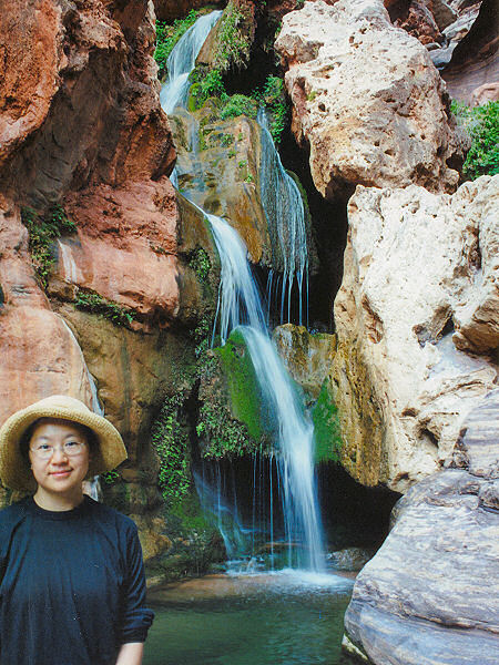
Day 3 - Side trip to Elves Chasm, Toltec drainage to Copper Canyon: From the Toltec drainage there is a nice side trip to Elves Chasm - a very pretty grotto and waterfall usually only seen by river rafters (the lazy bastards
 ). Follow the cairned route west along the Colorado as it travels up and down over rough volcanic rock. The going is fairly slow, but the canyon isn't far. The author and his wife completed the round trip in 2 1/2 hours.
Pick up your packs at the Toltec and follow
the route east as it passes over more rough
volcanic rock up along the hillside below the
Tonto Plateau. Eventually the trail will climb
up and into the major drainage of Garnet
Canyon (water available year round, though in
drier seasons it may be salty). From Garnet
the trail climbs up and out to the Tonto
Plateau where it becomes nice and flat (this
is also the official start of the Tonto
Trail). It's easy flat walking from here as
the trail winds in and out of a few minor
drainages through brittlebush covered slopes
with great scenery. Eventually you will arrive
at the major side drainage of Copper Canyon
(no water when the author was here). Copper
Canyon may be identified by the large yellow
dome of Mt. Huethawali which sits high above
Evolution Amphitheater at the head of the
canyon. The trail continues through Copper
Canyon to resume it's course along the Tonto
on the other side. When the author was here,
there were a few confusing
cairns leading up the drainage of Copper Canyon
(ignore them), the
only reason I can think of is that they mark a
path to water, though I followed them & none was found. The
author camped at a flat spot in Copper Canyon,
walk time from Toltec was 7 hours. ). Follow the cairned route west along the Colorado as it travels up and down over rough volcanic rock. The going is fairly slow, but the canyon isn't far. The author and his wife completed the round trip in 2 1/2 hours.
Pick up your packs at the Toltec and follow
the route east as it passes over more rough
volcanic rock up along the hillside below the
Tonto Plateau. Eventually the trail will climb
up and into the major drainage of Garnet
Canyon (water available year round, though in
drier seasons it may be salty). From Garnet
the trail climbs up and out to the Tonto
Plateau where it becomes nice and flat (this
is also the official start of the Tonto
Trail). It's easy flat walking from here as
the trail winds in and out of a few minor
drainages through brittlebush covered slopes
with great scenery. Eventually you will arrive
at the major side drainage of Copper Canyon
(no water when the author was here). Copper
Canyon may be identified by the large yellow
dome of Mt. Huethawali which sits high above
Evolution Amphitheater at the head of the
canyon. The trail continues through Copper
Canyon to resume it's course along the Tonto
on the other side. When the author was here,
there were a few confusing
cairns leading up the drainage of Copper Canyon
(ignore them), the
only reason I can think of is that they mark a
path to water, though I followed them & none was found. The
author camped at a flat spot in Copper Canyon,
walk time from Toltec was 7 hours.
Day 4 -
Copper Canyon to South Bass Trailhead: From
Copper, resume your hike eastward on the Tonto
Trail. The path climbs up the plateau once
again then follows a series of contoured
ridges. The dominant shrub along this section
is blackbush (different from the other side of
Copper, perhaps due to different soil
composition?). After rounding Tyndall Dome,
the major drainage of South Bass Canyon will
become visible. The trail heads into the
drainage where it joins the South Bass Trail
which leads left, down to the river, and
right, to the rim. Turn right and
begin the climb upwards. As you reach the head
of the canyon, the trail passes through a
brushy section before reaching the redwall for
the steep climb up to the Esplanade. Once on
top, you pass through a flat stretch of trail
as you head south towards the rim and the
junction you passed several days earlier. Stay
left at the junction and climb the remainder
of the way to the S. Bass trailhead. The author hiked
from Copper Canyon to South Bass Canyon in 2
hours, it took another 4 hours to reach the
rim. |