| |
Sycamore Canyon (Kelsey Spring
Loop) - Coconino National Forest
| Summary: |
A boulder
hopping loop hike through upper Sycamore
Canyon with a side trip to some very nice
narrows. Many springs can be found along this
route. |
| Directions: |
From Phoenix, take I-17 north to
Flagstaff. Head west on I-40 to the first
exit (Flagstaff Ranch Road, exit 192). Turn
left at the bottom of the exit ramp, drive a
short distance to a 'T' intersection and turn
left. After a couple miles you'll come to a
stop sign, turn right onto Woody Mountain Road
(Forest Road #231) which becomes a well graded
dirt road shortly thereafter. Drive for 13
miles then turn right on FR #538. Another 5.5
miles will bring you to an intersection and
sign pointing right for Dorsey Spring Trail (1
mile), Kelsey Spring Trail (2 miles). Turn
right, cross a cattle guard, and follow this
bumpy dirt road 1.5 miles to a left branching
road and sign for Kelsey Spring Trail. Turn
left and drive the remaining 0.5 miles to the
trailhead. |
| Road Conditions: |
High
Clearance Vehicle |
| Navigation: |
Moderate -
while there is no trouble following most of
this route, the Winter Cabin Trail out of
Sycamore Canyon is a little tricky to spot, if
you miss this turn off you might walk for
miles without realizing it. |
| Length: |
~15 miles (?) |
| Date Hiked: |
December 2001 |
| Weather Conditions: |
Nice, though
there was 4" of snow in the upper
elevations |
|
Required Skills: |

 |
| Hike Description: |
From the
Kelsey Spring Trailhead begin descending a few
steep, but short switchbacks. The trail then
descends more moderately and 10 minutes later
you will come to Kelsey Spring (and a new wooden
sign - no camping within 200 ft of the springs),
a piped spring & old steel tank which lies about
20 feet off the trail to the right (all springs
described on this trip were flowing vigorously
when the author was here). The trail bends left
and continues it's moderate descent through a
shady ponderosa pine forest passing Babes Hole
Spring (a stone box spring). After about a mile
you will come to a signed intersection: Kelsey
Trail #3 heads straight, Little LO Trail #6
heads right. Stay right on Trail #6 as it
continues downwards, becoming rather steep
towards the end as it drops down along the edge
of the interesting looking Little LO Spring
Canyon which is off to your right. Eventually
the path makes it's way to the canyon bottom
where Little LO Spring Canyon and Sycamore
Canyon meet and the signed Geronimo Spring (a
piped spring with wooden trough). Your path
heads left (south) at this point down the main
drainage of Sycamore Canyon. The canyon is full of baseball to beachball sized boulders that you will be hopping the entire way. The canyon walls alternatingly widen and narrow and occasionally look like they want to form some good deep narrows, but never do. The canyon is completely dry and probably only has water after an extremely heavy rain storm, though there were a few muddy patches along the way. To do a loop hike you want to find the Winter Cabin Trail #80 which enters the canyon on the left (east). Unfortunately it's a little tough to
spot since there are no cairns in the main drainage of Sycamore (though the author built one, that may or may not be there when you perform this hike). About 2 hours down stream from Geronimo Spring (remember I was walking fast) you will come to the beginning of a long straight away where you can see quite a distance down Sycamore Canyon. Looking down canyon you'll see some large conical shaped mountains on the right of the canyon in the distance. Directly on your right is Sycamore Point a large mountain, however, from the stream bed where you are standing it doesn't really look any different from the rest of the canyon, so it's not much good as a landmark. As you enter the straight away, look for a stream bed which enters Sycamore on the left hand side. The entrance to this drainage is a little blocked by
growth, but looking closely you will see a number of large cairns and a wooden sign for Winter Cabin and Ott Lake and a trail that leads up the left of the drainage. Turn left here and follow the Winter Cabin Trail #70. This trail begins climbing very steeply up a dry, sunny, chaparral covered slope. Scrub oak overgrows the trail in places, but it's never difficult to follow. As you gain altitude, you will get a better look of Sycamore Point which looms over the canyon behind you. The trail continues climbing steeply on the left of the drainage, eventually you will reach a sign for Ott Lake and a trail that heads back to the left. This side trail heads left, up and over a ridge then 5 minutes later drops down into a small oval field where it fades away (Ott Lake must be somewhere around here, or perhaps the field becomes a lake during certain times of the year). Our trail does not go to Ott Lake, however, so we will continue straight on the main trail past the Ott Lake sign. The trail continues relentlessly upwards, until eventually
it leaves the chaparral slope and enters a ponderosa forest. Shortly thereafter you will reach Winter Cabin, an old cabin in a grassy field with another nice spring (located just behind the cabin opposite to where the trail entered). There is a signed junction at the cabin: Winter Cabin Trail #70 heads right and Kelsey Trail #3 heads left. Turn left on trail #3 which, while not altogether flat, is graded much nicer than the trail you have been climbing for the past couple hours. The trail drops down through the woods a ways, then climbs up to an open chaparral covered slope which travels beneath a large escarpment off to your right. It heads west towards a large butte shaped formation which it passes to the right before dropping back down into the woods once again. Eventually you will come to a signed intersection with the Dorsey
Trail #7 which heads right, continue straight on the Kelsey Trail until you reach the intersection with the Little LO
Trail you passed earlier. Turn right and follow the trail the remaining mile back to your car. |
| Rating (1-5 stars): |

The author arrived at the trailhead
rather late due to the long drive from Phoenix
(10:30am). As a result he was rushed and hiked
quickly the entire way. The hike was completed
solo in 6.5 hours. He finished the hike as the
sun was setting. There is nothing terribly
interesting about Sycamore Canyon, but it's nice
enough. |
| Maps: |
Coconino National Forest Map |
| Books: |
Canyoneering
Arizona, Tyler Williams |
| Photos: |
Click picture for larger view, click your browser's 'Back' button to return to this page. |
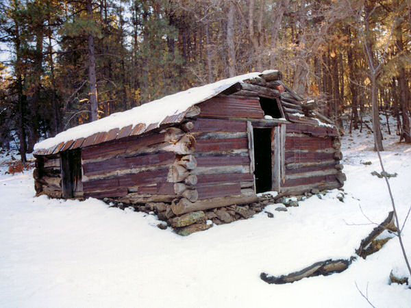 |
| Winter
Cabin - living up to it's name. |
|
|
