Updates
to Arizona: Technical Canyoneering will be posted on this page.
Please e-mail updates and current canyon conditions to:
[email protected]Error - Page
55: Reference Map of Canyons
On the map the locations of canyons 33 and 34 are reversed.
Canyon #1: Deer Creek Canyon
NOTICE: Lower Deer Creek Canyon is
closed to canyoneering until further notice.
http://www.nps.gov/grca/parkmgmt/upload/2012_grca_compendium.pdf
Mileage is listed incorrectly. Total hike distance is 19 miles.
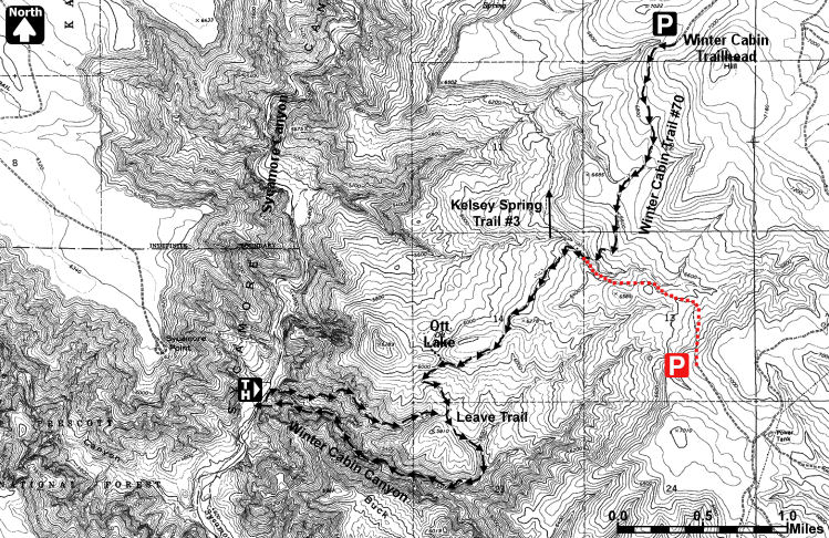
Canyon #7: Winter Cabin Canyon
The parking spot and entry route are incorrectly marked on the map
(the description is correct). See below, the correction is marked in
red.
Canyon #12: Barney Spring Canyon
Error - Page 107, The first sentence of the trip description
should read:
From the car
park, begin hiking due west
east, with a map and compass or GPS in hand, until you locate a
minor drainage leading away from the road.
I received a report that the canyon now has 3 bolts. These are
located at the top of the 100' rappel, at the top of the 4' jump and at the top of the
keeper pot-hole on the down-canyon side. A party reported they were
able to successfully escape the keeper pool (which was completely dry
at the time) using hooks in natural features - no drill holes
required.
Driving Directions: The following directions are better than ROUTE 1
in the book, following a much better road.
ROUTE 1 (shorter if coming from the south): From Phoenix, take I-17
north to Sedona (at the exit for Highway 179). Turn left onto Highway
179 and follow it through the town of Oak Creek to Sedona and the
intersection with Highway 89A. Drive 17.4 miles north on Highway 89A
and turn left on FR 535. Drive 5 miles on this dirt road to a sign
pointing left for Harding Point. Turn right (remaining on FR 535) and
drive 5.2 miles to a left branching junction with FR 536. Turn left on
FR 536 and follow it 0.8 miles to a 'T' junction. Turn right,
remaining on FR 536 and follow it 3.3 miles to where it ends at a 'T'
junction with FR 231. Turn left onto FR 231 (better road). Drive 12
miles then turn left onto FR 792. Drive approximately 1 mile and park.
Canyon #19: X-Pine Canyon
I received a report that a bolt has been installed at the
mid-way point of the first drop in the canyon. Though completely
unnecessary, the bolt is said to be well placed and will shorten the
amount of rope required to complete the canyon.
Canyon #27: Minnow Canyon
I received a report that a pair of bolts has been installed at the
top of the 150' rappel.
4/6/14 Update: I received a report that the bolts have been removed
and patched. Note - natural anchors are plentiful at this drop, it
shouldn't present a problem.
Canyon #28: Ladder Canyon
I received a report that SRP has closed off the road to Ladder
Canyon. Unfortunately, this canyon may now be off limits.
Canyon #32: Parker Creek Canyon
In the text 2 exits are described - a through trip of the canyon
with a car spot, and the Cadillac exit. Ignore both of these. The
canyon is best done by descending the technical portion of the canyon
to the 80' rappel. Just past this rappel on the right (west) side of
the canyon is a break in the cliffs which provides and easy, if
somewhat brushy route to the rim. Thanks to Jeremy for the tip!
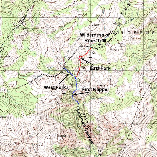
Canyon #37: Lemmon Canyon
I received a question about the entry to Lemmon Canyon and the
relative difficulties of the East and West Forks. There are two minor
upper tributaries of Lemmon which cross the Wilderness of Rocks Trail.
The first one you will pass is the East Fork (more difficult), the
second is the West Fork (less difficult). Both forks require climbing
on polished rocks, but my experience was that the west fork is the
easier of the two.
Please take a look at the map below which shows more detail about the
entry. I've marked the East Fork in Red and the West in Blue.
Approximate GPS coords are:
East Fork Entry: UTM 12N 518948 mE, 3586631 mN
West Fork Entry: UTM 12N 518433 mE, 3586218 mN
Typos:
|
