| |
Telephone Canyon - Zion
National Park
| Summary: |
A long steep
hike (2400' elevation gain) to a short technical
canyon with many rappels. To complete this
canyon you will need: good map reading skills, a
compass or gps, 2 x 60m ropes, harness w/ descending gear,
webbing, helmet and permit from the Zion
Backcountry Office. This canyon is normally dry,
though there may be a few easily avoidable
pools. |
| Directions: |
From within Zion National
Park, take the park shuttle to the Grotto Picnic
Area. The West Rim Trail begins across the
street at the bridge across the Virgin River. |
| Road Conditions: |
Passenger Car - paved all the
way |
| Navigation: |
Moderate |
| Length: |
7.7 miles, 8-10 hours |
| Date Hiked: |
September,
2002 |
| Weather Conditions: |
Nice with
brief showers |
|
Required Skills: |


 |
| Hike Description: |
Your journey
begins on the West Rim Trail. Climb all the way
to the junction with the right branching Angel's
Landing Trail. Stay left and continue climbing
the West Rim Trail. The path tops out, then
drops down to cross the bridge over Refrigerator
Canyon then continues climbing steeply up past
Behunin Canyon to the junction with the
Telephone Canyon Route. At this signed junction
the West Rim Spring lies 100 yards down on the
right (just a trickle when the author was here),
the West Rim Trail to Lava Point heads to the
left, the Telephone Canyon Route continues
straight (there are also 2 campsites in this
area). Stay straight on the Telephone Canyon
Trail past campsite #1 and walk for 10 minutes
to gps point 325494mE 4129074mN. Turn right into
the burned out forest and walk to the head of
Telephone Canyon at gps point 325549mE
4129213mN. The canyon is only about 1/4 mile
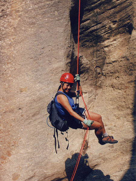
long, but it is one rappel after another. You
will be performing several double raps off of
the same anchor, so make sure someone in your
group identifies the next drop and anchor
before you pull your ropes. The canyon is
not terribly deep or narrow, but there are some
nice enough sections. Here's the low down on the
rappels:
Rap #1: 30' to a debris strewn shelf using a
burned tree at the head of the canyon
Rap #2: 100' (watch the debris!) to the edge of
a pot hole and shelf, then 20' to the bottom,
use the prominent tree near the edge as your
anchor
Rap #3: 50' from 2 bolts and hangers (b&h) on
the left
Rap #4: 2 b&h on the left, rap 35' then walk a
short hall way & rap 15' into a narrow sideways
slanting hallway
Rap #5: use the tree stump wedged in the
slanting hall to rap a steep 70' slope
Rap #6: 2 b&h on the right, mostly vertical 70'
drop
Rap #7: use an old log to rap 40' to a shelf
next to a pot hole
Rap #8: double rappel from a tree on the right a
little ways back from the edge, drop 20' walk a
short ways then rap 15' (could also rig the
second drop from a chockstone)
Rap #9: double rappel from a sling around the
big choke stone on the right, 15' drop then 35'
Rap #10: 15' drop, don't remember the anchor
Rap #11: double rappel from a dead tree on the
right, 30' then 10'
Rap #12: use the choke stone to rap 25'
Rap #13: last one! 2 b&h on the right will allow
you to rap 60' down the breakdown to the canyon
bottom
Pick up the faint use trail on the right and
follow the canyon around and out. Pick a route
across the slick rock heading south until you
run into the West Rim Trail. Follow the trail
all the way down to the Grotto, the shuttle and
your car. |
| Rating (1-5 stars): |

If you like to hike and like to rappel,
then this is the canyon for you - it's got lots
of both. The canyon is not particularly pretty,
but there are some good photo opportunities.
The author, his wife and two friends
completed this canyon at a leisurely pace in ~10
hours. |
| Maps: |
Trails Illustrated - Zion National Park, Zion N.P. Park Map |
| Books: |
None |
| Photos: |
Click picture for larger view, click your browser's 'Back' button to return to this page. |
 |
 |
 |
|
Rappel.... |
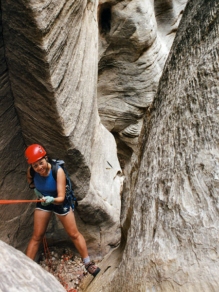
after rappel.... |
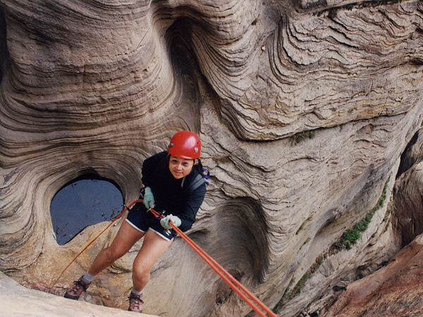
......after rappel. |
|
|
