| |
Lower Muley Twist Canyon - Capitol
Reef National Park
| Summary: |
A nice
stroll through a pretty canyon with a few
large alcoves and a short stretch of narrows.
According to the literature available at the
trailhead: "From 1881 to 1884, the canyon
served as a wagon route for Mormon pioneers
traveling south toward San Juan County. The
canyon was thought to be narrow enough to
'twist a mule' hence the name Muley
Twist." |
| Directions: |
From near
the Bullfrog Marina at Lake Powel, drive north
on Highway 276 for ~ 6 miles and head north on
the initially paved Notom-Bullfrog Road. The
road becomes well graded dirt as it heads
along the front range of Waterpocket Fold.
Continue north for ~35 miles until you come to
the Post (a small parking area on the right
(east) and a sign for Headquarter Canyon on
the left. Turn left towards Headquarter Canyon
and shortly you will come to a sign labeled 'Lower
Muley Twist Trailhead 1/2 miles'. There are
two parking areas: one for stock (which also
has a very nice restroom) and one for hikers.
Park and pick up a hike description at the
trail register. |
| Road Conditions: |
Passenger Car
(when roads are dry) |
| Navigation: |
Moderate |
| Length: |
15 Miles |
| Date Hiked: |
October, 2001 |
| Weather Conditions: |
Warm &
sunny |
|
Required Skills: |

 |
| Hike Description: |
From the
register, follow the sign for Muley Twist
Canyon. The trail heads west through the scrub
and soon begins a steep climb up Waterpocket
Fold over sections of slick rock (follow the
cairns through this area). About 45 minutes
later, the trail eventually levels off and
passes through a sandy area with juniper,
scrub oak, jointed fir, creosote bush and
ponderosa pine as it heads towards the dark
red Wingate sandstone canyon ahead. The trail
drops into Muley Twist Canyon and is marked by
several large cairns and a sign that says
'Post Cutoff Trail', which points back the way
you came. Turn left and head down canyon. The
next 8 miles is easy flat walking on packed
dirt between towering sandstone walls. The
canyon is not particularly narrow, however,
it's pleasant enough. Several times, where the
canyon makes a sharp bend, you will pass
through a huge undercut alcove. After about an
hour and a half, the right canyon wall becomes
a low red hill, while the left remains a tall,
yellow sandstone wall. Near the bottom of the
canyon it makes a bend to the left and passes
through the reef and a short stretch of nice
narrows. Once through this section the canyon
fades behind you as you continue down a wide
shallow drainage. Supposedly there is a
cairned route which heads left out of Muley
Twist, but I did not see it. No big deal,
simply walk the stream bed to it's junction
with Hall's Creek (note: this junction is not
particularly distinct - turn left when you
reach the first minor drainage at a dark red
rock wall and head north). You can either
follow Hall's Creek or look for an old wagon
road which crosses the creek periodically. The
road provides a more direct route back to your
car. The path heads roughly north/northeast as
it parallels the large escarpment that you see
off to your right and the yellow slope of
Waterpocket Fold on your left. The path north
is flat, sandy and boring, punctuated by
occasional battles with nasty scrubby thistle
like plants with star shaped burrs that appear
to take pleasure in jumping between your sock
and shoe (these plants appear to be common in
many of the overgrazed, cow damaged sites in
Utah). After a while you'll pass a sign for
Cottonwood Tanks and shortly thereafter you'll
arrive back at your car. |
| Rating (1-5 stars): |

The author and his wife completed this hike in
7 hours, wasting about 1/2 hour after missing
the turn north on Hall's Creek (be extra
careful at that junction). |
| Maps: |
USGS
7.5-Minute Series: Wagon Box Mesa and The Post |
| Books: |
Canyon
Hiking Guide to the Colorado Plateau -
Michael Kelsey |
| Photos: |
Click picture for larger view, click your browser's 'Back' button to return to this page. |
 |
 |
|
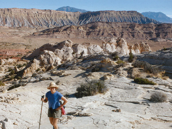
The start of the hike. |
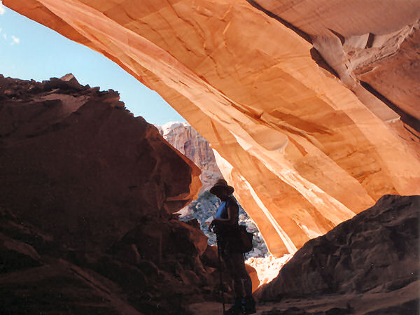
View
from one of the deep alcoves. |
 |
|
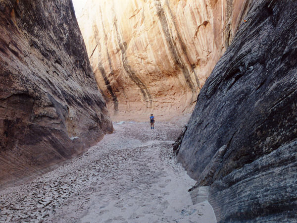
The
narrows at the
end of Muley Twist. |
|
|
|
