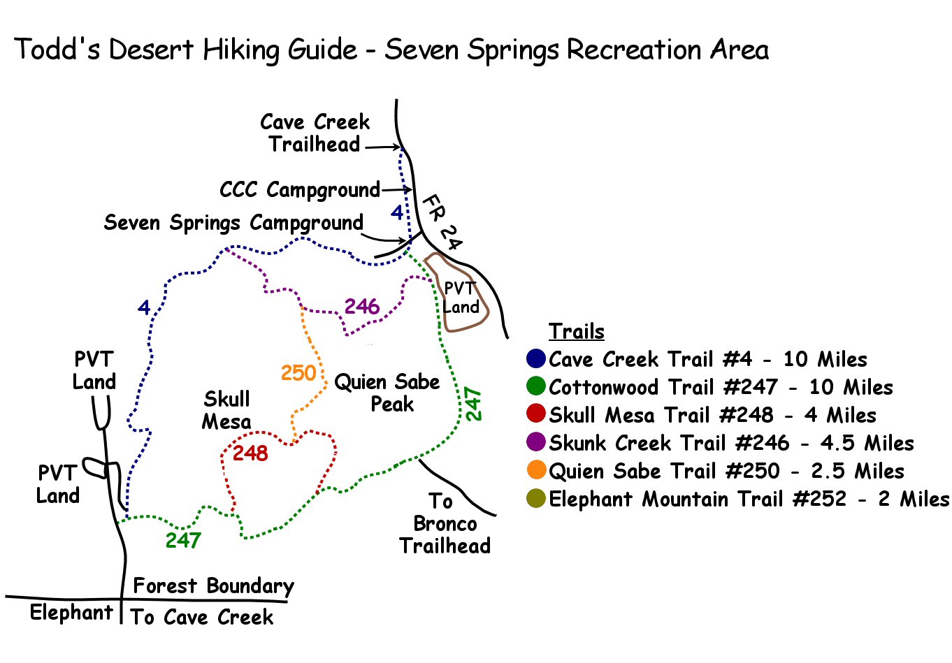
| |
Seven Springs Recreation Area,
Outer Loop - Tonto National Forest
| Summary: |
The Seven Springs Recreation
area is located just north of the town of Cave
Creek. Be aware that this is a fee area ($4 per
carload per day). Several decent loop hikes can
be made from the Cave Creek Trailhead. I will
describe a long loop hike circumnavigating the
entire area using the
Cottonwood and Cave Creek Trails. Be aware that
mountain bikes and horses are allowed on all
trails in the area. |
| Directions: |
From Phoenix,
drive north on I-17 to exit #223 and head east
on the Carefree Highway. Drive all the way to
the end at a 'T' intersection and turn left on
Tom Darlington Dr. and follow it a few miles
until it ends at Cave Creek Rd. where you'll
turn right. You'll pass a small airport on the
left and further down the road, Desert Mountain
(also on the left). Where the road splits,
you'll see a sign for Bartlett Lake & Rangers
Station to the right; you'll want to stay left
(this is Forest Road 24). Shortly afterwards
you'll pass a sign for Seven Springs, Sears Kay
Ruin, Camp Creek, Residential Area. After 2
miles you'll enter the Tonto National Forest. At
the 4.5 mile point the pavement ends in a well
graded dirt road. Continue winding along the
road, at the 12 mile point you'll hit a short
stretch of pavement as you enter the Seven
Springs Recreation area and Cave Creek
Campground (there is an
electronic self service fee station in the
middle of the road when you enter the area.
). Drive past the
camp sites & look for a green 'Trail' sign which
points to a parking area (with bathroom) on the
left side of the road. |
| Road Conditions: |
Passenger Car |
| Navigation: |
Moderate - the path is
generally easy to follow and all trail junctions
are signed, but there are a few faint sections
of trail |
| Length: |
20
miles |
| Date Hiked: |
December 2003 |
| Weather Conditions: |
Warm and sunny |
|
Required Skills: |
 |
| Hike Description: |
The loop is described
traveling clockwise. From the Cave Creek
Trailhead pick up the Cave Creek Trail #4 as it
travels behind the campgrounds paralleling the
road. The path crosses a dirt road (ignore the
unsigned junction on the left, and remain on #4)
and drops down beside Cave Creek to a junction
with the left branching Cottonwood Trail #247.
Turn left on #247 which crosses the stream then
climbs a hill to the junction with the Skunk
Creek Trail #246 which branches right. Stay left
on the Cottonwood Trail which climbs a grassy
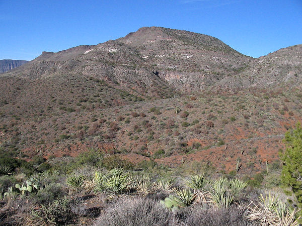
slope dotted with: juniper, prickly pear, cholla,
scrub oak, bursage, cat's claw and sugar sumac.
The path bends right and enters a wide gully,
traveling along a hillside; first on the right,
then on the left side, until you eventually
reach a junction with the left branching trail
#245 (which is not shown on the map, but I
believe it leads to the Bronco Trailhead). The
trail then begins climbing gently through an
area of low rolling hills, past a fence then
down the other side to follow a wash. Shortly
after climbing out of the wash on the right,
you'll reach a junction with the right branching
Skull Mesa Trail #248 (5 miles), stay straight
on #247. The trail follows a ridgeline down to a
wash, becoming more rocky as it goes and
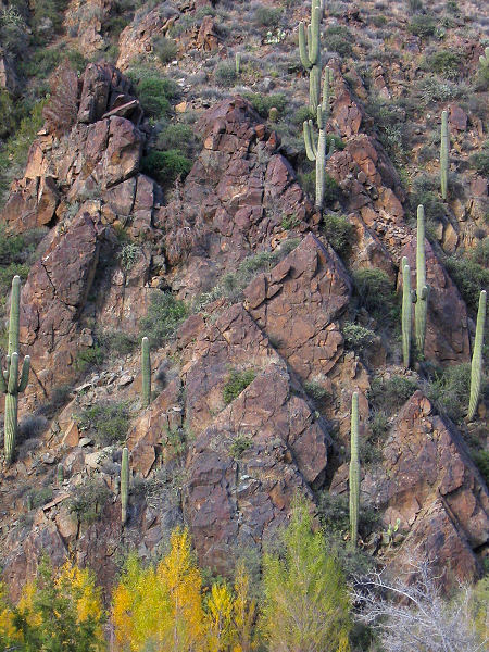
entering lower desert with saguaro and jojoba.
Once in the wash the path is somewhat faint,
simply walk down the wash. After passing a corral it climbs up and over a
low hill on the right to follow another wash
(notice a trend yet?). After passing another
corral the path bends right then begins climbing
moderately towards some white outcropping of
rock on the edge of Skull Mesa. As you enter an
area with dirt of a dark brown color, the path
becomes somewhat faint as it climbs the rocky
hillside in an area which exhibits the
characteristics of overgrazing. Look for small
cairns which lead up to a shoulder which is
divided by a fence and contains a signed
junction with the other end of the Skull Mesa
Trail which heads right). Continue through the
fence, remaining on the Cottonwood Trail as the
path follows a ridge line down, crosses a wash,
performs a short, steep climb to another ridge,
then begins descending once again. You'll catch
a glimpse of Forest Road #48 as you complete a
series of switchbacks, finally reaching the
signed junction 'T' with the Cave Creek Trail #4
which heads right (left will take you to the FR
#48 road end). Turn right and begin walking up a
wide dirt road (10 miles). When you reach a
saddle, the path becomes more of a trail as it
begins to wind it's way up a wide valley between
two prominent ridges. The scenery changes little
over the next 5 miles as you stump along the
rocky path. Eventually, after passing through a
fence, you will reach an sign which indicates
the Skunk Creek Trail #246 is 2 miles ahead,
Cottonwood Trail is 5 miles (15 miles). A bit
further, after passing a corral and gate, the
rocks underfoot abate somewhat as the path
becomes somewhat more level as you begin to
follow a drainage, which was flowing when I was
here, to a junction with the right branching
Skunk Creek Trail #246 (Quien Sabe Trail #250 is
2 miles right, Cottonwood Trail is 5 miles
right). The sign also indicates that the Cave
Creek Trailhead is 5.5 miles straight, which is
incorrect, the distance is closer to 3 miles (17
miles). Continue straight as the path bends
right
to follow a flowing stream on one side of the
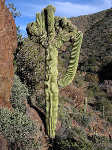
bank or the other. Look for a good example of a
crested saguaro when the trail is traveling
along the left hillside above the stream bed.
After passing this cactus the path drops down
and crosses the stream bed, travels on the right
hillside for a while, then descends to stream
level, following a wide flat track through the
riparian vegetation to the junction with the
right branching Cottonwood Trail you had taken
earlier. Continue straight the remaining
distance back to your car (20 miles). |
| Rating (1-5 stars): |

A nice long desert hike which is nice enough,
if a bit rocky. The author completed the hike at
a brisk pace in 8 hours, which included a 0.5
hour detour to look for some secret ruins and
petroglyphs. |
| Maps: |
Tonto
National Forest Map or Click
here (note: I
reproduced this this map by copying the sign the
Forest Service placed at the Cave Creek
Trailhead. It is only as accurate as the Forest
Service made it.) |
| Photos: |
Click picture for larger view, click your browser's 'Back' button to return to this page. |
|
|

