| Hike
Description: |
From the
signed trailhead begin hiking up the Reavis Ranch Trail on a smooth well
graded path as it ascends moderately into the rolling hills of the eastern
Superstitions. After about 2 miles you will reach a small pass after which
the trail becomes somewhat rockier, though still ascends at the same
moderate grade. This portion of the hike passes through grassy rolling
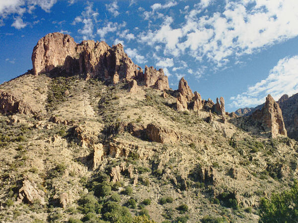
hills up towards Castle Dome, the pyramid
shaped mountain you see off to the right. The trail then passes Castle
Dome to the east heads through Windy Pass (which as it's name implies
always seems to have a brisk breeze blowing through it) then heads down on
the west side of the hill. Shortly afterward you will arrive at the signed
junction with the Plow Saddle Trail (6.4 miles). Turn right onto the Plow
Saddle Trail (don't make the mistake of heading off in the direction that
the sign is pointing, head 90 degrees right, walk 15 feet then turn 90
degrees left, you'll see some cairns and the trail). The Plow Saddle Trail
heads fairly steeply down the hill eventually heading along the right side
of a wash where a few Cottonwood Trees are growing, then down into the
wash itself. After a short walk of 0.4 miles you'll come to Plow Saddle
Springs (there's an old hard to read sign if you can find it) with an old
concrete tank and coral (6.8 miles). There is no trail sign at this point,
but the trail branches right (for the longer hike to the ruins) and left
(for the shorter loop back to the Reavis Trail).
Shorter Hike: Turn
left at Plow Saddle Springs. The trail winds it's way along the hillside,
then up through a juniper dotted slope before joining the Reavis Ranch
Trail 1.5 miles later (8.3 miles). Turn left on the Reavis Ranch Trail and
follow it 1.4 miles back to Plow Saddle (9.7 miles), then follow it the
remainder of the way back to your car (16.1 miles).
Longer Hike: Turn
right at Plow Saddle Springs, onto the 5.4 mile long Frog Tanks Trail. The
path winds along the hillside, climbs a low ridge before descending a
fairly steep slope in the general direction of the gap in the cliffs you
see below you. Eventually the slope becomes more moderate as the trail
enters the trees in the bottom of Rogers Canyon (water flowing when the
author was here). This area with pines and grass strikes me as decidedly
un-Arizona like (but nice). A short distance after passing Hole Spring
(with more tanks and a coral) the trail makes a steep but short climb up
the right side of the hill, winds along the slope a ways, then drops just
as steeply down into Canyon once again. The trail becomes a little faint
as it passes through the trees, then dumps you into the stream bed of
Rogers Canyon. From this point the trail bends left and follows the stream
on one side or the other up one of the prettiest canyons in the
Superstitions. After a few miles the canyon widens and you'll find
yourself in Angel's Basin, a large grassy area with plenty of camp sites.
Off to the right in the basin is a sign pointing back the way you came for
Frog Tanks, the rest of the sign is trashed (12.2 miles). Continue up
Rogers Canyon in the same easterly direction you have been traveling for
the past hour (do not head up the trail to the right past the sign
mentioned above). A few tenths of a mile up canyon look up on the left
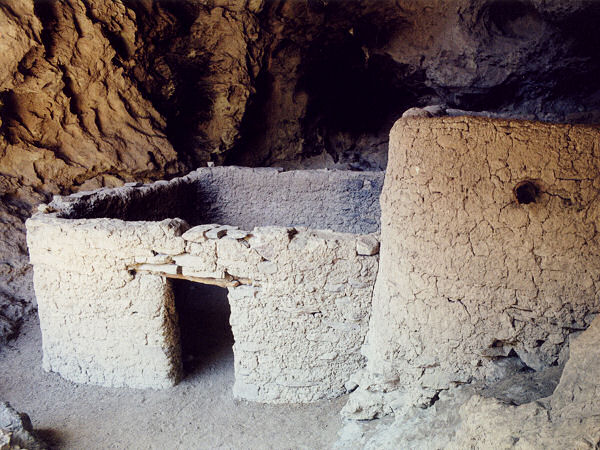
hand wall for the shallow caves and the Indian ruins. The ruins were
constructed approximately 600 years ago by Salado Indians and are some of
the best preserved and well constructed ruins the author has seen
anywhere. This area is fairly popular and except for some carving in the
beams of the ruins by ignorant ass wipes, most people appear to be fairly
respectful of the place. Though I probably do not need to remind the
reader, please do not disturb, touch or climb on ruins. Look, study,
photograph, then when ready, return the way you came (easier said than
done since you still have over 12 miles to go and some pretty good climbs
ahead of you (24.5 miles).
|