| |
Rogers Trough Loop #2 - Tonto National Forest
| Summary: |
This hike creates a loop from
the Rogers Trough Trailhead using the West Pinto
Creek, Pinto Peak, Fire Line, and Reavis Ranch
Trails. An optional detour to view a
circular wall ruin on Mound Mountain is also
described. |
| Directions: |
From Phoenix drive east on Highway 60
1.8 miles past Florence Junction and turn left
on Queen Valley Road. Drive another 1.8 miles
and turn right on Hewitt Station Road (Forest
Road #357) which immediately becomes well
graded dirt. Drive 3 miles and turn left onto
FR #172 at a brown sign pointing the way to
Superstition Trailheads: Woodbury 11 miles,
Rogers Trough 12 miles. After several miles
the road crosses a dry stream bed then begins
traveling through a high walled canyon. Keep
an eye out on the left hand side in this area
for a small natural arch (featured in David
Meunch's AZ photo book). After 9.3 miles you
will reach a sign for the Woodbury Trailhead
1.5 miles left, Rogers Trough 3 miles to the
right. Stay right on FR #172A and drive the
remaining 4 miles (not 3 as the sign
indicates) up this rather steep road to the
large parking area and trail head. |
| Road Conditions: |
High
Clearance Vehicle |
| Navigation: |
Moderate, I got turned around
a few times because several junctions were
unsigned - but I didn't have the advantage of
this detailed trip report to guide me
 |
| Length: |
19.9
miles, add another 2 miles if you want to visit
the ruins on Mound Mt. |
| Date Hiked: |
March 2003 |
| Weather Conditions: |
Warm
and sunny |
|
Required Skills: |

 |
| Hike Description: |
The trail
starts between the two rust brown posts at the
end of the parking lot. After about 5 minutes
you'll come to a signed junction with the right
branching West Pinto Trail (0.2 miles). Turn
right, walk past the corral (close the gate behind
you) and begin the short but steep climb up to a
saddle of Iron Mountain. At the saddle you'll
pass through another fence and then begin
descending moderately down the other side, as
the path winds its way along the east slope of
the mountain. The path soon bends right and
begins a steep descent of a chaparral covered
ridge into the valley below, where it begins to
follow a wash at a more gentle grade down
stream. The path crosses the wash a few times
before climbing out on the left and traveling
along the slope above. It's an easy downhill
stroll on a well maintained path (very different
from the first time I did this hike, and had to
push through a thicket of scrub oak the entire
way). The trail eventually crosses to stream
right, and after some more walking, drops down
into an area labeled as Oak Flat on the map
(there are good camp sites in this area). After
crossing a wash you'll arrive at a signed
junction with the Spencer Creek Trail #275 (6.4
miles). Turn left at this junction and follow
the wash downstream for a minute or two. When
you see a sign for the West Pinto Trail #212
(which continues straight and back the way you
came) look for cairns that cross the stream
(there is a corral on the opposite bank that will
help identify this junction). Turn left and
cross the stream. The junction is unsigned, but
you are now on the Pinto Peak Trail (note: the Beartooth map does not depict this section
correctly, follow my directions above instead).
A short distance after passing the corral, the
trail begins climbing steeply with views up to
the red dome of Pinto Peak above you. The trail
skirts the peak to the south & continues
climbing as it passes through a fence line.
Eventually the path descends a short distance to
cross a wash, only to resume climbing at an even
steeper grade on the other side through an area
consisting almost entirely of scrub oak, sugar
sumac and manzanita. Finally you will reach a
saddle and fence line, only to descend down the
other side into the valley below (the trail is a
bit overgrown along this section). Once down on
the valley floor, the trail winds its way down
the drainage of Campaign Creek on one side or
the other (or even right down the creek itself).
After following the creek for a ways, keep your
eyes open for a forested area with prominent
camp and fire ring. When you reach this spot,
look for cairns that exit the camp on the left.
This is the unsigned junction with the Fire Line
Trail (10.5 miles). Turn left on the Fire Line
Trail, which immediately begins a steep climb
through the chaparral on a sunny path. The trail
climbs up to a saddle, descends a short distance
into a wooded area, then continues its steep
ascent. When the trail levels out after this
second climb, you will pass a well cairned trail
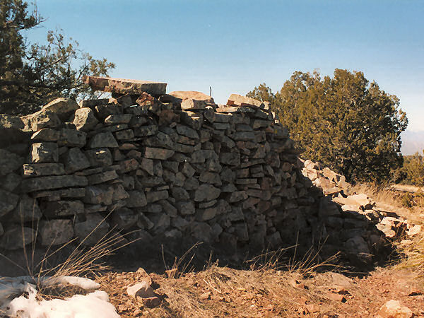
which branches left. This ~1 mile spur trail
leads up Mound Mt. to a large circular ruin &
makes an interesting side trip if you have time
to spare. Continuing from this spur trail, the
Fire Line Trail is easy, flat walking. After
passing through a meadow, the route begins
descending along a particularly eroded section
of trail. You'll then pass through a wide open
section of chaparral before dropping down into a
valley and the signed junction with the Reavis
Trail #109 which goes right and left (13.9
miles, not including the 2 mile side trip to the
ruins). Turn left and follow this pleasant
little path as it winds its way through riparian
areas, pine forests and grasslands (just as you
enter the grassland you pass one of the biggest
alligator junipers the author has ever seen).
The path eventually begins climbing a bit more
moderately up to a low saddle, then begins
descending on the right down into the drainage
of Grave Canyon. It's easy walking the entire
way as you continue down canyon, crossing the
wash a few times in the lower canyon, before
arriving at the signed junction with the right
branching Rogers Canyon Trail #110 (18.4 miles).
Continue straight on the Reavis Trail which
bends left and begins climbing up the drainage
of Rogers Canyon. It's a moderate climb, but if
you're doing this as a day hike like I did, the
uphill will be tiring. The path crosses the
stream bed a few times as it skirts Iron
Mountain to the west. Finally you will come to
the signed junction with the left branching West
Pinto Trail you had taken earlier (19.7 miles)
and a short distance later your car (19.9
miles). |
| Rating (1-5 stars): |
 
The author completed this trip as a day hike
on two occasions. The first time the author and
his wife hiked the loop the opposite way as
described above. On this first trip, the West
Pinto Trail was horrendously overgrown with
scrub oak, and we ended up finishing the last 4
miles in the dark. On my most recent trip, I
hiked the loop described above solo, at a quick
pace, with a side trip to the ruins. The hike
was completed in 9 hours. |
| Maps: |
Beartooth Maps - Superstition Wilderness Topographic Map |
| Photos: |
Click picture for larger view, click your browser's 'Back' button to return to this page. |
 |
 |
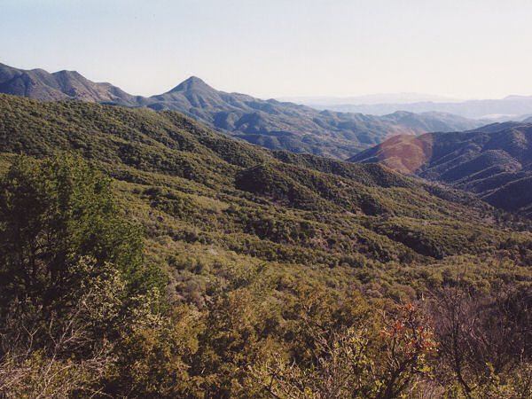
| View of the
valley from Iron Mt. |
Rock walls on
the side trip. |
|
|
