| Hike
Description: |
Begin walking on the trail (0 miles, 4220
ft) just past the large brown sign for the Barnhardt Trailhead (this sign is
supposed to show some of the main trails in the area, though it doesn't make
any sense to me). A couple feet past the sign is a signed junction:
Barnhardt Trail (#43) heads straight & the Shake Tree Trail (#44) heads
left, continue straight ahead on the Barnhardt Trail. The path is wide and
rocky at first as it heads through a stile then begins following the south
side of the drainage of Barnhardt Creek through a scrub forest of emory oak,
alligator juniper, scrub oak, one seed juniper & prickly pear. About 15
minutes later you will pass a sign marking the Mazatzal Wilderness Boundary.
The trail continues to ascend moderately for the next several miles. Look
for a narrow break in the rock on the left hand side - about 100 feet up
this short drainage is a nice waterfall (when it's flowing, which it
probably isn't). In the upper end of the canyon, manzanita becomes more
common and eventually becomes the dominant plant species. The trail bends
to the right around the head of Barnhardt Creek & shortly thereafter reaches
a signed junction with the right branching Sandy Saddle Trail #231 (4.2
miles, 5960 ft), turn right onto the Sandy Saddle Trail. The path descends somewhat steeply to a dry streambed and crosses it a few times
(look for cairns in this area), then begins climbing, gradually at first,
then more steeply up a rocky slope to top out at at a sandy saddle (what did
you expect?). The trail then begins descending beside (and sometimes in) a
rocky streambed on a somewhat faint and overgrown path (keep your eye out
for cairns) to end in a 'T' junction with the Divide Trail (7.2 miles,
6040 ft). Turn
left on the Divide Trail and in a few minutes look for a dry wash which runs
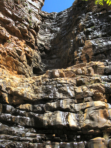
parallel to the trail on the right. To visit the falls, leave the trail and
walk down this dry wash for 5 minutes to the edge of a large cliff band and,
if the stream is flowing, a 250' falls. The falls plunge about 120' to a
ledge, then another 100' to a shallow pool.
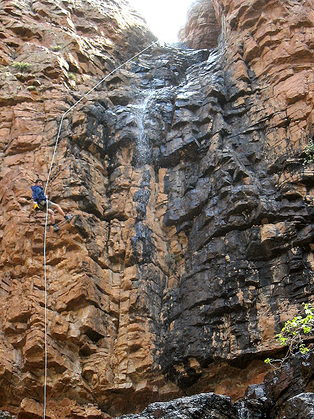
For most, this view of the falls will be
plenty. Adventurous types with rope ascending skills can rappel the falls to
explore down this right fork of Deadman Creek. To perform this stunt you'll
need a minimum of two ropes; 170' and 100' in length, harness, descending
and ascending gear and decent climbing skills. The first rappel can be
rigged with the longer rope using a sturdy alligator juniper tree located
~30' back from the top of the falls on stream left (there are 2 beach ball
sized boulders immediately in front of this tree). This rappel will bring
you to an obvious ledge. If the rock is dry, it is possible to down climb
the rest of the way to the pool at the base of the falls (beware that the
rock is smooth and could prove dangerous when wet, in this case a safer
means down would be to bring a 250' rope and rappel all the way into the
pool, which was about 3' deep when the author was here). A short trip down
canyon will bring you to a second drop off & falls. If you have a long rope
(maybe 150'?) you might be able to rappel directly down this drop off. If
you only brought a short rope like me, you can climb up and around to the
right until you have a view of a steep grass covered slope to the north. Rig
your rope from another alligator juniper tree to get past an annoying cliff
band, then down climb the remainder of the way to the slope, which can be
descended with some care to the base of the second falls. Explore down
stream & when ready return back up the falls using your ascending gear to
get back up the ropes.
When ready, walk back up the streambed to the Divide Trail
and continue south on this rocky and level path as it winds its way through
a corridor of manzanita. Shortly after catching some views of the
rugged south face of Mazatzal Peak and
Suicide Ridge you'll reach a signed junction with the Barnhardt Trail (11
miles, 5660 ft).
Stay left on the Barnhardt Trail trail which is quite flat for the next few
miles as it travels through more manzanita corridors & in and out of shallow
ponderosa pine filled drainages below the rounded humps of Mazatzal Peak
until it reaches the junction with the Sandy Saddle Trail you took earlier.
Stay right on the Barnhardt Trail and follow it back down the mountain to
the trailhead and your vehicle (17.1 miles, 4220 ft). |

