| |
City Creek Loop - Tonto National Forest
| Summary: |
A mostly loop, super aggressive day hike
or more reasonable multi-day backpacking trip in a little visited area of
the Mazatzal Wilderness. A bit of bush wacking and route finding is
required.
Note: This hike was completed prior to
the Willow fire which burned through the Mazatzal Wilderness in
June and July of 2004. Actual trail conditions
may differ from those described below. |
| Directions: |
From Phoenix, take the Bee Line Highway (Highway 87)
north to Payson. Soon after entering the town, turn left at the lights onto Main Street. There are a few jogs in the road, but stay on the main
one. After 2.5 miles, the pavement ends in a well graded dirt road and
it becomes Verde Valley Road (FS
#406); continue ahead. About 10 miles from Payson, the road drops down to the
left, then switchbacks to the right and begins following City Creek. A few hundred
feet from the switchback, look for the signed City Creek Trailhead and
parking area on the right hand side. |
| Road
Conditions: |
Passenger Car |
| Navigation: |
Moderate to Difficult |
| Length: |
The semi-loop as described is 27.6 miles
With this write up you could also do a 20.2 mile hike to Fuller Seep and
back or a 18 mile out and back hike to The Park |
| Date
Hiked: |
April 1998 & February 2003 |
| Weather
Conditions: |
Nice |
|
Required Skills: |


 |
| Hike
Description: |
From the parking area, cross the road &
pick up the trail which soon leads to a gate and sign for the Mazatzal
Divide Trail, Red Hills Trail (0 miles, 3440 ft). The trail begins climbing
moderately on the right side of the City Creek drainage (get used to the
climb - you have several hours of it ahead of you). Vegetation in the area
consists of juniper, yucca, prickly pear, grasses and scrub oak. After about
1/2 an hour, you will pass through a fence and the path bends right, then 10
minutes later you'll pass what's left of the Mazatzal Wilderness, Tonto NF
boundary sign. The path continues its ascent and you'll begin to see more
agave, manzanita and sugar sumac. Some more climbing up a few wide
switchbacks and you'll have views to the north of the Mogollan Rim and above
you to the prominent dome of North Peak. The upper sections of trail are a
bit overgrown with scrub oak, though the path itself is easy to follow. When
you round a corner which bends right and see a rock escarpment above, you'll
know you're almost there. A short climb will bring you into a shady
ponderosa pine forest and a few minutes later, a signed junction. The Divide
Trail, which you have been following heads left, to the right is the Red
Hills Trail, Brush Trail and Midnight Trail (5.5 miles, 6080 ft). Turn right
and descend a short distance, then look for an abrupt turn to the left (look
for cairns which mark the trail throughout). Follow the path as it winds its
way down into a shallow ravine, through a pleasant pine forest, passing an
old corral at one point. After crossing a wash (which had a few pockets of
water when the author was here), the trail begins a gradual ascent next to
another shallow drainage, then climbs more steeply, becoming more scrubby
and sunny as it climbs to the head of the drainage. A short easy walk will
bring you to the signed junction with the right branching Brush Springs
Trail. Continue straight on the Red Hills Trail (8.3 miles, 6080 ft). The
path winds its way across the plateau, then begins a steep descent along a
sunny, rocky slope towards the valley below. Take care in this section since
the many loose rocks make for poor footing. When you reach the valley floor,
the trail becomes less steep and rocky as it winds its way down on the right
side of the drainage. Soon you'll reach the creek and a sign for Fuller Seep
which had many pools when I was here (note: I have read that water is
available year round at Fuller Seep (10.1 miles, 5280 ft); I'm not sure I'd
want to bet my life on it though, so I carried some extra water as a
precaution). There are good camp sites at the seep and an old corral. The
path then crosses the stream bed and follows a fence for a while as it
continues west through the chaparral. After 1.5 miles, you'll reach a signed
junction (though one of the signs was lying on the ground), the Midnight
Trail and Deadman Trail 2.5 miles to the left, Dutchman Grave Trail 10 miles
straight (11.6 miles, 5420 ft). Stay to the left and begin a steep and rocky
descent back down to the drainage that Fuller Seep feeds. The path crosses
the pink granite boulders of the drainage three times before climbing a low
hill on the left and descending into the next drainage over, which is Wet
Bottom Creek (13.1 miles, 4460 ft). There may be water a short distance up
this creek. The path crosses the stream bed, heads up a side drainage, then
begins following this drainage on the left hand side on a faint and heavily
overgrown path. After crossing to the right, the brush fades a bit, then
it's a somewhat steeper climb to the head of the drainage and signed
(damaged & barely readable) junction (14.1 miles, 5300 ft) with the Willow
Spring Trail #223. The Divide Trail is 5 miles to the left, Mountain Spring
is 2 miles to the right. Head left on a faint path that travels along a
shoulder through an area that is heavily overgrown and brushy. It's a
struggle at times as you push your way through the scrub oak. Finally, the
trail begins descending along a somewhat less brushy, but still indistinct
path. Soon after passing through a nice stand of smooth bark cypress, the
path crosses a sandy stream bed (look for cairns), then begins climbing a
steep rocky slope. As you ascend, you'll have views to the right, across
Maverick Basin, to some steep cliffs. After a long climb, you'll round a
shoulder, then begin descending into a nice forested area of Ponderosa Pine
and Alligator Juniper. Shortly after crossing a dry wash, you'll reach a
signed junction in an area called The Park (19.1 miles, 5860 ft). The Divide
Trail heads left and right at the junction; we'll stay left towards the Red
Hills Trail which is 3 miles distant. A 15 minute walk through the woods
will bring you to the right branching North Peak Trail #24, continue
straight. The path climbs and descends a few moderate to steep hills,
eventually breaking out onto a ridge composed of conglomerate rock and
covered with shin daggers. A short walk down the ridge will bring you to the
intersection with the Red Hills Trail you passed earlier (22.1 miles, 6080
ft). Stay right and begin the long decent back to the trailhead and your car
(27.6 miles, 3440 ft). |
| Rating
(1-5 stars): |

The author completed this hike on two occasions. The first time, with an
early start and fast pace, I completed it as a long day hike (not really
recommended). Later, I returned with my wife and hiked it as a two day
backpacking trip. Walk time on this second trip was 7 hours from the
trailhead to where we camped at Wet Bottom Creek, then another 8 hours the
next day to complete the hike. Between the two trips I saw one other person
(a forest ranger). |
| Maps: |
Mazatzal Wilderness Tonto
National Forest, USFS |
| Photos: |
Click picture for larger
view, click your browser's 'Back' button to return to this page. |
 |
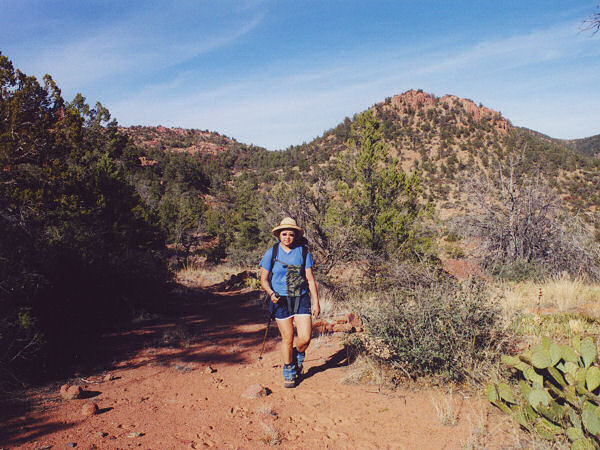 |
| The long climb from the trailhead. |
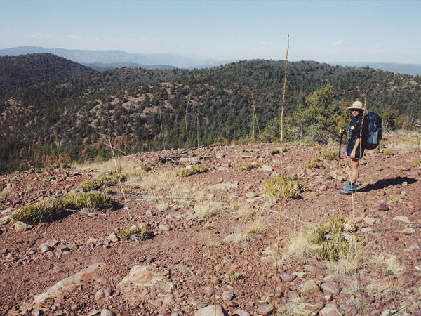
Typical view on the hike. |
 |
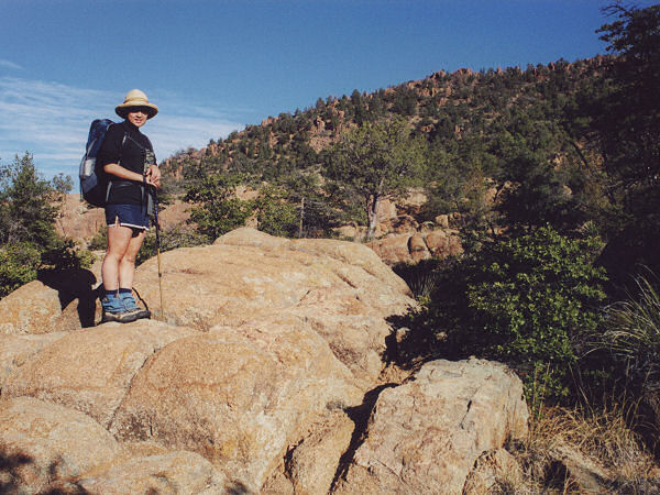 |
Pink granite on the way
up to The Park. |
Conglomerate outcropping
& shindaggers. |
|
|
