| |
Tonto Creek - Tonto National
Forest
| Summary: |
A strenuous, multi-day backpacking trip along the rugged drainage of
Tonto Creek through deep narrows. The trip requires
a considerable amount of climbing, wading and swimming
to complete. Most
groups should be able to finish the hike between
2.5 - 4 days, though it could take longer. In
order to enjoy this hike, it helps to be well
prepared. To that end here are a few tips:
1. Keep all your critical gear in waterproof
containers. This includes food, dry clothes and
sleeping bag. Most dry bags leak, so it helps to
double dry bag these items or use a
dry keg. I
do not suggest carrying an inflatable boat or
inner tube. These items are heavy and easily
punctured. In fact you'll see quite a few of
these floatation devices that people have abandoned in the canyon,
being too lazy and inconsiderate to remove their own
trash when their toys became useless. Another
advantage of dry bags is that they will also add floatation to your pack, which
is essential for the many long swims. With a
buoyant pack, you can swim by either laying on
top of it and
kicking, or wearing it with the hip belt
fastened and doing the back stroke (my personal
preference).
2. Water is very heavy, you do not want to be
lugging several gallons of Tonto Creek water out
with you after every swim. Carry a pack that drains
well and that lacks open cell foam
padding that can absorb water. Grommets should
be placed in the bottom of the pack to allow
water to escape.
3. Do the hike when temperatures are very hot
(above 100 F). Swimming is unavoidable. You will
be soaked much of the time and can easily become
chilled. A wet suit may be desirable during
cooler weather or for skinny people.
4. Wear shoes that have good traction even when
they are wet. The rock in the canyon is
extremely smooth and slick. A walking stick may
be useful for balance.
5. Do the hike during periods of dry weather.
Rains churn up the mud making the creek run
brown (as can be seen in photos in the
Hellsgate Trail #37
hike referenced below). The hike will be
considerably
more difficult if you can not see the rocks
beneath the water.
6. Purify all water before drinking.
7. Plan your camping about an hour in advance.
Campsites are interspersed throughout the
canyon, but they may not be located exactly
where you'd like them to be. Be flexible as to
where you stop and be ready to settle for a site
that isn't ideal.
8. I would also suggest carrying a light weight,
fully enclosed shelter. The canyon has some
unpleasant blood sucking insects that would like
you to be their friend for the night. |
| Directions: |
!Update!
The lower car spot at
Gisela has been barricaded and marked as a tow
zone. Evidently some badly behaved individuals
have ruined access for the rest of us.
Car Spot:
From Phoenix head
north on Highway 87 towards Payson. Just after
you pass the sign for the Barnhardt Trailhead
turn right following the sign towards Gisela.
Follow this paved road up and over Black
Mountain staying straight at any branches. The
road becomes well graded dirt, continue straight
until you reach a 'T' intersection with mail
boxes in front of you and Gisela Valley Farms on
the right. Turn left and continue to follow the
main road until you reach a metal gate with pull
off area on the left. Park here.
Trailhead: From Payson,
drive east on Highway 260 for 11 miles to mile
marker 263. Turn right just past the mile marker
and drive 0.5 miles on a well graded dirt road
to a clearing on the right. There is a large
Forest Service sign next to a fence for
the Hellsgate Wilderness. |
| Road Conditions: |
Passenger Car |
| Navigation: |
Easy |
| Length: |
22 miles |
| Date Hiked: |
July 2006 |
| Weather Conditions: |
Hot and sunny |
|
Required Skills: |


 |
| Hike Description: |
Approach Trail: Follow the
Hellsgate Trail #37
for 7.5 miles
to Tonto Creek.
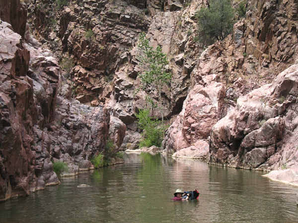
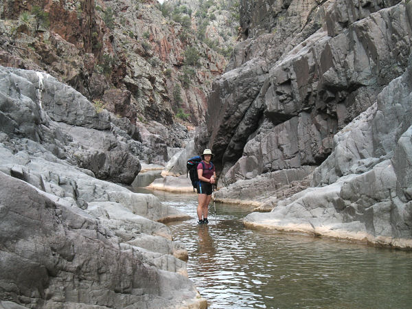
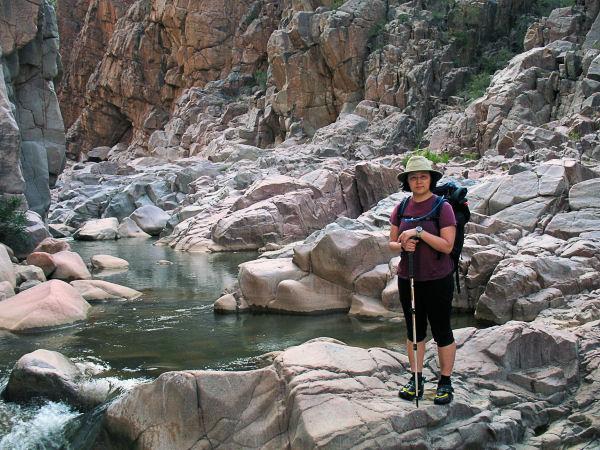
Tonto Creek: Once in Tonto Creek, head down
canyon. You will soon pass Haigler Creek which
enters from the left. The wading and swimming
begin in short order and after a bit of hiking
the canyon begins to deepen, eventually entering
a very scenic red quartzite box canyon. You will
be in and out of the water continuously from
this point on. The routine is to rock hop down
stream, wade into a pool until you can no longer
touch bottom, swim to the other side, and wade
out again. Occasionally there are routes around
on the left or right that can offer quicker
progress than wading or swimming. The quartzite
fades somewhat as you near Goswick Canyon and
the swimming is slightly less frequent. Below
Big Canyon the walking becomes somewhat easier
with fewer swims and rocky benches that you can
walk for increased distances. The creek then
enters a very nice gorge with polished gray rock
walls with a few small cascades and a natural
arch. These narrows end in a long swim just
above the confluence with Derrick Canyon, which
enters from the right. Below Derrick, the creek
is rather straight and somewhat less scenic
until a point where the canyon bends to the
right and the large drainage of Spring Creek
enters from the left. Just past this point the
canyon deepens once again, entering a section of
colorful narrows where the rock is a swirling
mixture of reds, yellows, purples, and grays.
Just above McDonald Pocket, after another
particularly long swim, the canyon walls fade
back and saguaros appear on the banks. If you
are hiking on a particularly hot day, the air
temperature seems to rise ten degrees in this
section due to the heat reflecting off of the
rocks underfoot. The canyon is fairly wide for a
while, then becomes somewhat more narrow as pink
granite appears underfoot. The granite erodes
very differently than the other rock in the
canyon creating complex, undulating shapes which
are interesting to look at, but very difficult
to walk on. There are also many large boulders
just beneath the water surface in this section
that make footing tricky. The banks are also
very steep which means you have to swim right up
to them before you can touch bottom to climb
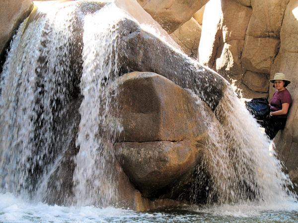
out. Towards the end of this section, the canyon
drops more steeply forming a few short
waterfalls, the last of which is particularly
nice and ends in a long pool. It's more rock
hopping and swimming below this section for
another hour or so until you come to the popular
swimming hole at the Tonto Narrows. You can
either swim through the narrows or bypass them
by walking the ledge on the left. Just below the
narrows, pick up a well used trail on the right
that heads through the mesquite trees. After the
path crosses Houston Creek it bends right and
climbs out of the canyon to a road and ranch.
Follow the road 0.5 miles to the lower car spot
and the vehicle you'd left there earlier. |
| Rating (1-5 stars): |

The author and his wife completed the hike as a
2.5 day trip at a moderate pace. Day 1 we hiked
10.5 hours to camp near Big Canyon. Day 2 we
hiked 10 hours and camped on a bench across from
a large, but un-named canyon at McDonald Pocket.
Day 3 we hiked out in about 4 hours.
Total hike time was 24.5
hours at a steady pace (averaging just under 1
mile per hour). Because of all the climbing and
swimming some groups could take much longer. |
|
Books: |
Canyoneering Arizona -
Tyler Williams |
| Photos: |
Click picture for larger view, click your browser's 'Back' button to return to this page. |
|
|