| |
Italian Spring to Mica Mountain
(the full tour), Saguaro National Park East
| Summary: |
This hike takes you up an infrequently traveled path to the top of
Mica Mountain (the tallest point in Saguaro NP East) via the Italian Spring
Trail, then takes you on a looping tour of all the natural features of the
mountain before returning the same way. Those wishing to do a shorter hike
could just do an up and back to Spud Rock. |
| Directions: |
From I-10 near Tucson take the Grant Road
exit #256 and head east. Follow Grant east and turn left on Tanque Verde
Road. Stay on Tanque Verde until it eventually turns into Redington Road.
After a few miles, Redington becomes well graded dirt and climbs up into the
hills. Watch the side of the road for green mile marker signs which are
posted every 2 miles. Drive 0.5 miles past mile marker 12 and turn right
onto Forest Road #37 (which is rough and requires 4-WD). Zero your odometer
here if you'd like to follow along with my directions. Less than a tenth of a mile in
on FR #37, you'll come to
what looks like a 4-way intersection - stay straight heading down a rough
hill. At the 1.5 mile point you'll pass right branching Forest Road #4424 -
stay straight on FR #37. At the 2.2 mile point, and again at 2.5, you'll
pass through barbed wire fences and shortly afterwards (at 2.7 miles) the
road drops into a wash. The Italian Spring Trail begins on the other side of
the wash and is marked by a plastic sign. Park under the big tree on the
right. |
| Road Conditions: |
4-Wheel Drive |
| Navigation: |
Easy |
| Length: |
Out and back hike to Spud Rock - 16 miles
The full tour - 21 miles |
| Date Hiked: |
April, 2005 |
| Weather Conditions: |
Sunny & warm |
|
Required Skills: |
 |
| Hike Description: |
From the dry wash (0 miles), walk up the trail and soon
you'll step over a metal hitching post and reach a sign for Italian Spring
Trail #95 which informs you that the official Park boundary is 4.5 miles
ahead. The trail follows an old road, up through rolling hills covered with
grass and mesquite trees, towards the mountain. After 2.2 miles you'll cross
a wash (flowing when I was here) to reach a barbed wire fence and an old sign
indicating the Park boundary is now 2.3 miles ahead (2.2 miles). The path
becomes more trail-like at this point and climbs steadily through the
foothills of the mountain into an area with interesting rock
formations. You'll also begin to notice that the path is marked with orange
metal disks nailed to the trees (though you won't need them, the
trail is obvious). As you ascend steeply you'll pass through several
areas that have been burned by wildfire and up a few sections of trail that
are badly eroded into deep gullies. At higher elevations, oak and juniper
become more prevalent, and provide some occasional shade. Eventually,
you'll pass through a shiny gate at the Park boundary (4.5 miles). There is
a trail register and sign indicating that Italian Spring is 2 miles ahead.
Continue climbing steeply up the hill, passing through an area heavily
damaged by fire. When the path bends right, it levels off somewhat as it
traverses the side of the hill, entering a pine forest with occasional views
north of Mt. Lemmon before arriving at Italian Spring and a 'T' junction
with the North Slope Trail (6.5 miles). The spring is right next to the
trail and is little more than an algae filled puddle. Turn left on the North
Slope Trail towards the Fire Loop Trail and continue climbing. The path soon
enters a healthier pine forest and tops out at a ridge at a 'T' junction
with the Fire Loop Trail (7.1 miles). Turn right towards the Bonita Trail
and stay right again (towards Spud Rock) at the next two junctions with the
left branching Bonita and Mica Mountain Trails (7.4 miles). It's easy
walking for the next 0.6 miles as you pass over the top of Mica Mountain
which has a few concrete blocks remaining from an old lookout tower, but
little in the way of views due to the tree cover. The path then descends
(first time this trip) to a junction with the left branching Spud Rock Trail
(8.0 miles). Stay straight towards Spud Rock which you'll reach in 0.2
miles. There is a short spur trail on the right that leads up to the top of
the rock, which features good views in all directions. Interestingly enough,
there is another Spud Rock on the east side of Mica Mountain at the top of
the Turkey Creek Trail. Either those who named the formations on this
mountain were not terribly good at coming up with new names, or, it's
possible they just had an unusual fascination with potatoes. At any rate,
Spud Rock makes for a good destination and can be used as a turn around
point for those wishing to do a 16 mile hike. We, however, are going for the
full tour and when finished soaking in the view from the Spud, will continue
our progress west along the Fire Loop Trail which continues its descent
through the pines to a junction with the Cow Head Saddle Trail (8.6
miles). Stay straight (or to the left) towards Manning Camp which you'll
arrive at 0.4 miles later (9.0 miles). The camp consists of a few buildings,
a trail register and has water available year round.
Here's the story on Manning Camp if you're interested:
"The Manning cabin was built in 1905 by Levi Manning, Surveyor General of
the Arizona Territory and Mayor of Tucson. Levi and his family spent
several summers here raising vegetables and cattle, and escaping the heat
of Tucson. He abandoned the cabin in 1907 when the Rincon Mountains were
added to the Coronado National Forest. In 1933 this area was made part of
Saguaro National Monument which was renamed Saguaro National Park in 1994.
The National Park Service uses the cabin for fire and trail crews,
researchers and rangers. The cabin provides an important base for
prescribed burn operations. Pack mules deliver supplies to this remote
cabin which is on the national register of historic places."
From the camp, go straight on the Manning Camp Trail
towards the Devil's Bathtub Trail as it leads past the front of the building
towards a post that holds a sign reading "Manning Camp, Arizona". A short
distance later you'll reach the Manning Campground which has a toilet and
several camp sites with bear vaults. The path continues to descend to cross
a stream, which it follows for a short distance before the stream bends off
to the right. The path contours around the hill to the junction with the
left branching Devil's Bathtub Trail (10.0 miles). Turn left on the Devil's
Bathtub Trail towards Heartbreak Ridge and in 0.5 miles you'll reach a small
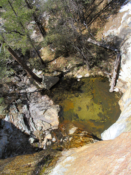
sign on the right for the Devil's Bathtub. The bathtub consists of a spring,
trickling waterfall and plunge pool. The trail continues past the tub at a
fairly level grade for another 0.7 miles to a 4-way junction (10.7 miles)
with the right branching Heartbreak Ridge Trail. The East Slope Trail heads
straight. Turn left at this junction and follow the path (not sure of the
trail name) up the hill towards the Fire Loop Trail. The path climbs up to a
ridge and continues up to a junction with the right branching Switchback
Trail (11.1 miles). Continue straight towards the Fire Loop Trail which
you'll reach, after a steep climb, 0.7 miles later (11.8 miles). Turn right
onto the Fire Loop Trail and walk past the rock formation of Man Head to the
junction with the left branching Mica Meadow Trail (12.3 miles). Mica Meadow
is easy flat walking and a peaceful area of fields, pines and rocks and
makes for a nice lunch spot. Stay straight at the junction with the Mica
Meadow Trail and straight again where the Bonita Trail branches left. Soon
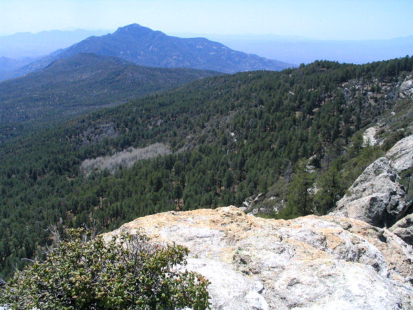
you'll reach Reef Rock which lies just off the trail to the right. The
escarpment offers some nice views east of forests and hills and south of
Rincon Peak. The trail continues to wind its way north on the side of the
hill, eventually passing another reef-type rock, after which point the trail
climbs up to a field with several old boxes containing 5-gallon water
bottles (for fire fighters I assume), then reaches the junction with the
right branching North Slope Trail which you had walked up earlier that day
(13.9 miles). Turn right, and follow the North Slope Trail 0.6 miles down to
Italian Spring (14.5 miles). Turn right on the Italian Spring Trail and
retrace your steps back to your vehicle (21.0 miles). |
| Rating (1-5 stars): |
 
The author completed this hike solo, at fast pace, in 8.5
hours. |
| Maps: |
National Geographic Trails Illustrated -
Saguaro National Park |
| Books: |
None used |
| Photos: |
Click picture for larger
view, click your browser's 'Back' button to return to this page. |
 |
 |
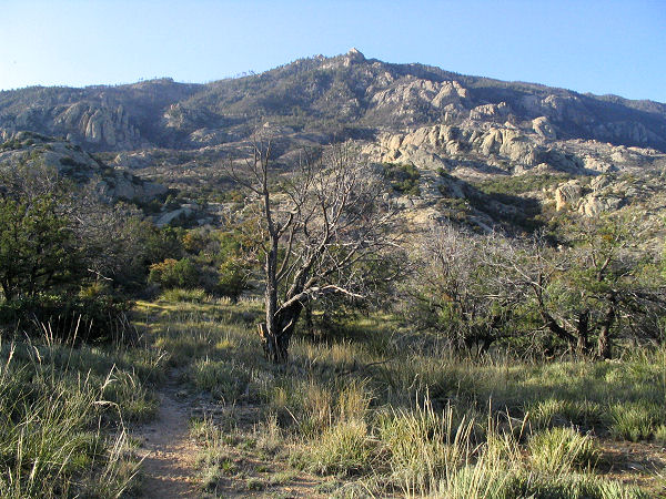
| The start of the hike. |
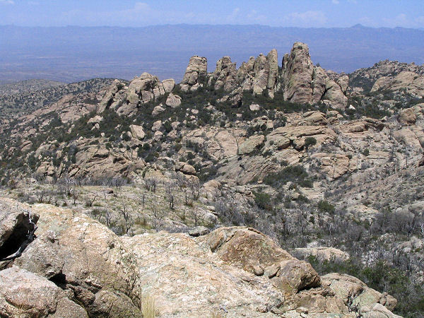
Rocky area ascending the
mountain. |
 |
 |
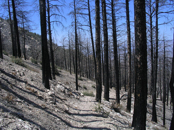
| Burned trees. |
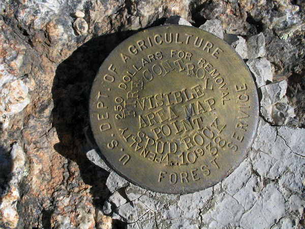
Marker on top of Spud Rock. |
 |
 |
| The
Devil's Bathtub. |
View
of Rincon Peak from
Reef Rock. |
|
|
