| |
Alconquin Trail to Hells Hole Falls -
Prescott National Forest
| Summary: |
A nice enough 1/2 day hike to a small
waterfall and pool in the Castle Creek Wilderness Area of the Prescott
National Forest. |
| Directions: |
From Phoenix drive north on I-17 to exit
#248 for Bumble Bee and Crown King (this is also the exit for the Horse
Thief Basin Recreation Area'). Drive west on the main road which becomes
well graded dirt in about two miles. Stay on this main road which goes
through the one horse town of Bumble Bee then begins climbing into the
Bradshaw Mountains. Take your time driving, the road is one lane in places
and sees a fair amount of traffic on the weekends (many driving faster than
is prudent). About 150' before the mile 25 marker, where the road takes a
sharp bend to the right, look for the pull out on the left (south) side of
the road , and park. |
| Road
Conditions: |
Passenger Car, though a High Clearance
Vehicle would be better |
| Navigation: |
Easy |
| Length: |
4 miles |
| Date
Hiked: |
November, 2002 |
| Weather
Conditions: |
Cool and sunny |
|
Required Skills: |
None |
| Hike
Description: |
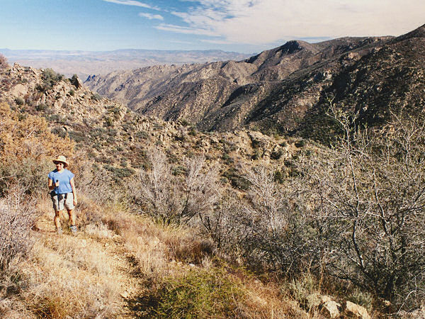
From the car park you'll have good views
to the south down into the drainages that run through Hells Hole. Begin
walking on the unsigned, but well developed trail which descends moderately
to the south through the chaparral (predominantly scrub oak, prickly pear,
bear grass and cats claw). After 5 minutes or so, you'll pass a faded wooden
sign labeled 'Alconquin Trail #225' and shortly thereafter a register and
another sign (this one in better condition) which reads 'Horse Thief Canyon
Trail #30 - 3 miles, Horse Thief Basin - 5 miles, Senator Road #52 - 6
miles'. Continue along the path (which is slightly overgrown in places) as
it descends moderately to the drainage below. Where the trail crosses the
first stream bed, hop off the path and head left down stream. This side
drainage is unlikely to be flowing (though there were some puddles when the
author was here). Be careful on the rocks, they are polished smooth and
quite slick. When you reach the confluence with the main drainage which
enters from the right (and is hopefully flowing), stay left and continue
down stream. There is a little bit of bush wacking involved in this section,
but it's a fairly easy task to keep your feet dry. This area is fairly nice,
with small pools and cascades gurgling through polished granite boulders.
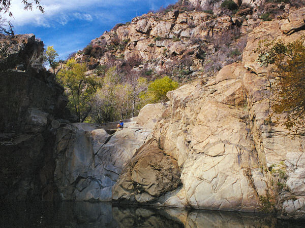
Soon your progress will be blocked by a 100' long pool which lies between
granite walls. If it's warm and you don't mind getting wet, your best bet is
probably to wade the pool... if you're wimpy like me, you'll probably want
to keep your feet dry. Most people would probably want to bypass the pool by
climbing high around this section on one side or the other. If your group is
composed of good climbers, you can climb on the granite slope on the right
which lies just above the pool. If you choose this option, be aware that
there is one tricky down climb near the end with a bit of exposure. Once
past the pool, it's a short 5 minute walk to the falls and pool. I expect
that most people turn around here, since another tricky climb is involved to
descend the falls (the author went down on the left). The drainage continues
through a short nice section below the falls before widening a short
distance later. When ready return the way you came. |
| Rating
(1-5 stars): |
 
The author and his wife hiked down to the falls, did some exploring below,
ate a leisurely lunch, then returned in just under 4 hours. |
| Maps: |
Prescott National Forest map - though
it's not very good |
| Books: |
None |
| Photos: |
Click picture for larger
view, click your browser's 'Back' button to return to this page. |
 |
 |
| Hike out through the chaparral. |
Hells Hole Falls. |
|
|
