| |
Piestewa Peak (formerly Squaw
Peak) - Phoenix Mountains Preserve
| Summary: |
A popular, short, steep climb
to the top of Piestewa Peak. The hike also gives you the opportunity
to practice your trail etiquette: descending
yields to ascending, slower yields to faster,
and those with dogs yield to all.
Three hikes are described, or combine them all
for a longer day. |
| Directions: |
While there are several ways
to access the preserve, most people use one of
the parking lots off of Squaw Peak Drive (which,
as of this writing, hasn't been renamed yet, but
don't get me started). The easiest driving route
is to take State Highway 51 to Exit 5 for
Glendale Ave and Lincoln Dr. Turn east on
Glendale and drive 0.5 miles to Squaw Peak
Drive. Turn left (north) on Squaw Peak Drive and
drive through the residential area into the
preserve. Most people try to park at the Summit
lot (first parking lot on the left after passing
through the gate) since it offers the quickest
route to the top of the mountain. The last lot
is usually the least crowded (and that's where I
parked for this trip). |
| Road Conditions: |
Passenger Car |
| Navigation: |
Easy |
| Length: |
2.4 miles - Hike to
the summit and back (1200 ft vertical gain)
3.7 miles - Circumference Trail (in the process
of being renamed to, believe it or not, the
'Freedom Trail')
4.7 miles - Quartz Ridge Loop |
| Date Hiked: |
December 2004 |
| Weather Conditions: |
Cool and cloudy |
|
Required Skills: |
None |
| Hike Description: |
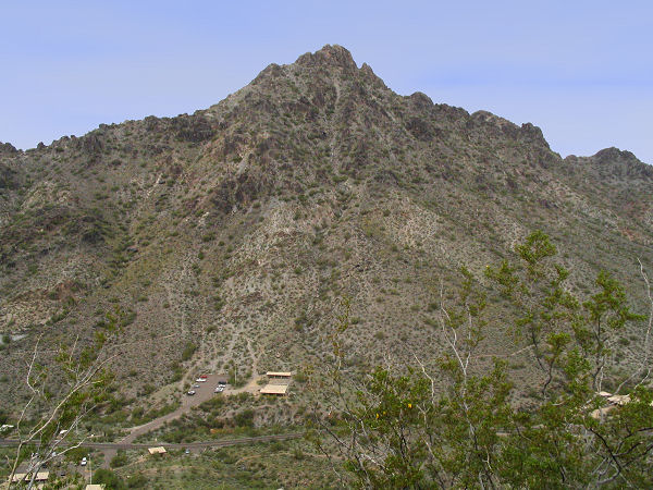
Summit Trail (no pets
allowed): From the Summit parking lot, pick up
trail #300 (0 miles, 1408 ft) as it begins
climbing moderately up the hill along an almost
paved path. After 0.2 miles you'll pass a
junction with the left branching alternate
summit trail, stay straight. The path then
climbs some constructed steps for 0.4 miles
before reaching a junction with the
Circumference Trail #302. Turn right and begin
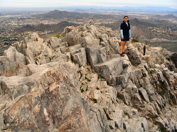
climbing steeply for 0.6 miles to the summit
(1.2 miles, 2608 ft) which features 360 views of
lovely downtown Phoenix. Return the way you
came.
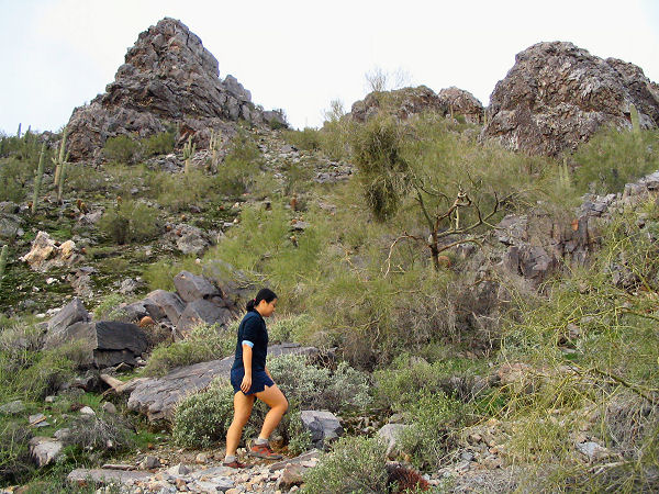
Circumference Trail: From the Squaw Peak
Drive road end pick up Trail #302 which is
accessed just left of the Phoenix Mountain
Preserve sign. A short walk will bring you to
the loop. You can go either way, but I'll
describe it counterclockwise. Turn right on
Trail #302 (which is also #304) and begin
climbing gradually to the north, dodging the dog
dropping as you go. You will pass a few
interpretive signs at first since this first
section trail is also part of the Nature Trail
#304. The path bends left and climbs more
steeply (stay left at all junctions along this
route except one - the route to the summit). The
trail climbs up to a saddle, then begins
dropping steeply down the other side. After
rounding the northern section of the peak, the
path bends south and traverses a not so scenic
slope with views of the smoggy city to the west,
then does a short, steep climb to a saddle and
junction with the left branching summit trail.
Stay straight and descend a series of stone
steps to just before the parking area, at which
point Trail #302 bends left and follows the road
north to the end and your car.
Quartz Ridge Loop: From the Squaw Peak
Drive road end pick up trail #304 as it heads up
a moderate slope to the north. After a couple
minutes you'll reach a junction with the right
branching Trail #8B, stay straight on #304. The
path climbs up to a low saddle and forks, turn
right on Trail #8 which is flat easy walking
(making it attractive to horses and mountain
bikes). Eventually Trail #8 bends left at a
junction with Trail #8A, stay straight on #8A
which winds through the desert to arrive at a 4
way junction (Trail #8B branches left) at the
top of a low rise. Stay straight on #8A which
begins dropping steadily towards basin to the
south. Just prior to reaching a parking lot off
of 32nd St, turn right on Trail #200A (the A is
for Alt). This path winds its way along the side
of the hill behind a number of houses before
eventually bending right, climbing up a shallow
drainage to a saddle and junction with Trail
#200. Stay straight, passing a short wooden
fence, and descend to Squaw Peak Drive. Turn
right and follow the road to its end and your
car. |
| Rating (1-5 stars): |
 
I'm not a fan of these city hikes, so take the
rating for what it's worth. The author and his
wife completed the Circumference and Summit
Trails in 2.5 hours then hiked the Quartz Ridge
Loop in another 2 hours. |
| Maps: |
Beartooth
Maps - Phoenix Area Mountain Parks |
| Photos: |
Click picture for larger view, click your browser's 'Back' button to return to this page. |
|
|