| |
Coyote Buttes - Paria Canyon /
Vermillian Cliffs Wilderness
| Summary: |
A cross country trek to some
spectacular photo ops including the Teepees
(multicolored, conical sandstone buttes) and
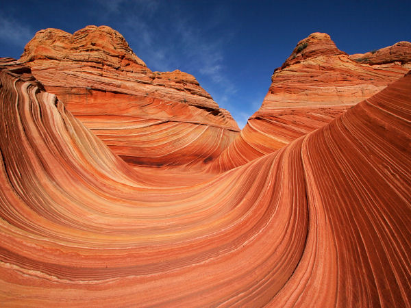
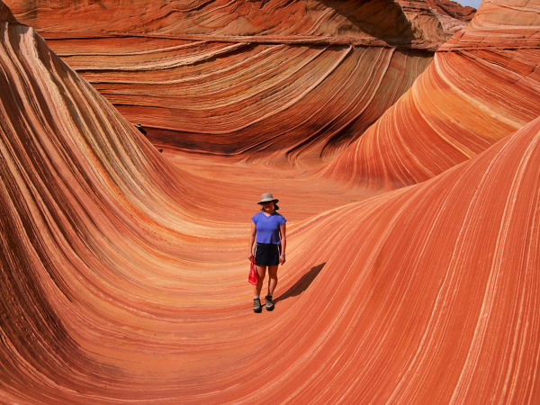
The Wave (a swirling, cross bedded sandstone
formation that looks like a petrified wave).
Oh, did I mention the rules? There are lots of
them. This area is managed as a partnership by
the Arizona Strip Field Office, Kanab Field
Office, BLM, Arizona Strip Interpretive
Association (ASIA) and Northern Arizona
University (maybe a strong case that too many
cooks spoil the broth?). First off you'll need a
permit (separate application for each day of
use), they cost $5 per person per day and are
available in one of three ways:
On line at:
https://paria.az.blm.gov/
By mail at: Paria Permits, ASIA, 345 E.
Riverside Dr., St. George, UT 84790
By fax at: 435-688-3246
Your dog also has to pay the $5 entry fee, but
he doesn't require a permit (ha! they actually
list that in the written material). Use is
limited to 10 people per day in each of the
north and south sections of Coyote Buttes, with
a single group size limited to 6.
Sort of a heavy handed approach, and I have no
doubt it's only a matter of time before all
public lands (emphasis on the word 'public') are
managed in this same bureaucratic fashion. Note:
the Teepees mentioned in this report lie outside
of Coyote Buttes. As long as you can skirt
the management area you are free to visit them
without a permit. |
| Directions: |
There are several access
points to Coyote Buttes, I have used two. From
Highway 89 between Kanab and Page, head south on
House Valley Rock Road which lies between mile
markers 25-26 (closer to 26) just west of the
curve in the road and guard rail. Drive south on
this well graded dirt road to the Wire Pass
Trailhead (it's about 8 miles from Highway 89,
you can't miss the big trail sign). A few years
ago I also hiked in from The Notch Trailhead
which is located another 2 miles or so past the
Wire Pass entry on the AZ side of the border.
There is no sign marking The Notch, just a short
spur road on the west which leads to a metal
tank (I used the map in Michael Kelsey's book
referenced below to find this spot, though I
drove by it a few times before finally locating
it). |
| Road Conditions: |
Passenger Car - take it slow |
| Navigation: |
Moderate - Difficult, there
are no trails, but lots of footprints and visual
clues |
| Length: |
~5 miles round trip to The
Wave and back, add several more miles to visit
the Teepees |
| Date Hiked: |
November 2002 |
| Weather Conditions: |
Sunny & nice |
|
Required Skills: |
 |
| Hike Description: |
From The
Notch, look to the ridge to the east an locate
the notch in the escarpment. Route find your way
up and over this ridge into the valley below.
Walk north through the sand if heading to The
Wave or explore at will.
From the Wire Pass parking area, walk across the
road and follow the prominent trail as it heads
through a stile then into a wash. After 15
minutes, you will come to a sign pointing down
the wash for Buckskin Gulch. There is a well
established trail which leads to the right out
of the wash and up the slope. This is the trail
to The Wave and begins at GPS point: 12S
409464mE 4097518mN. Turn right and walk up the hill; a
register is waiting for you at the top (you can
pick up a paper with information, a lame map,
and long list of rules at the register). There
is no real trail from here on out, but The Wave
sees a lot of traffic so foot prints should be
present in abundance (at least on the sandy
sections).
If your destination is The Wave, follow the main
group of tracks as it heads through the sand and
across the slick rock in a southeasterly
direction. The Wave lies near the mouth of the
two ridges formed by the taller red sandstone of
the Coyote Buttes (which is on your right) and
the shorter yellow sandstone ridge of Top Rock.
As you enter the drainage between these two
ridges look on the east (Top Rock side) for foot
prints leading up a sandy slope. Follow the path
up the slope to The Wave (GPS 12S 410462mE
4095114mN).
If you are bound for the Teepees, you will need
to head cross country to the southeast, but more
east than if going to The Wave. A map might be
helpful, however, the Teepees sit up on a sandy
ridge and are visible from a distance, so I
didn't really need one (if you have a GPS head
towards 12S 411586mE 4093509mN). As you slog along try to
minimize creation of new trails (though your
impact is probably minimal compared with that
already inflicted by cattle). There are several
groups of Teepees up on the ridge, the northern
most group is the most photogenic. |
| Rating (1-5 stars): |

The hiking in this area is ok, lots of sand
slogging. There are many great opportunities for
photos though. On his first visit, the author
and his wife hiked from the Notch Trailhead
looking for The Wave. We missed it and wound up
too far north looking into Wire Pass, before
hiking back and finding it. On our second trip,
we went in from Wire Pass, hiked cross country
around the north and south Teepees then over to
The Wave and out again in about 6 hours. |
| Maps: |
None used |
| Books: |
Canyon
Hiking Guide to the Colorado Plateau -
Michael Kelsey
Hiking and
Exploring the Paria River -
Michael Kelsey |
| Photos: |
Click picture for larger view, click your browser's 'Back' button to return to this page. |
 |
 |
|
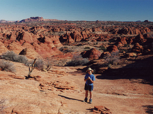
Headed cross country through
the Coyote Buttes. |
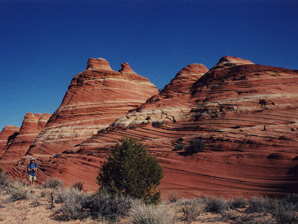
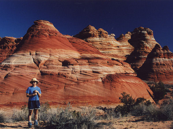
The Teepees. |
 |
 |
|
More Teepees |
The Wave |
 |
 |
|
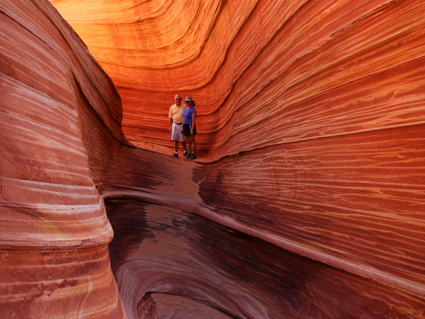
More Wave |
 |
 |
|
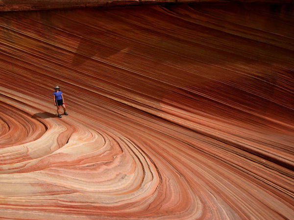
And Still More
Wave |
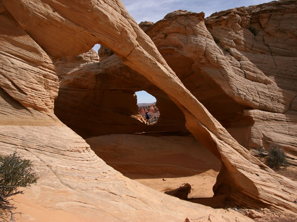
Melody Arch |
|
|
