| |
Buckskin Gulch / Paria River
Semi-Loop - Paria Canyon/Vermilion Cliffs Wilderness
| Summary: |
This classic hike begins at
the Wire Pass trailhead following Buckskin Gulch
to its junction with the Paria River, then
heading up-river to the White House Trailhead.
Along the way you will hike through the longest,
and one of the most scenic, slot canyons in the
world (Buckskin Gulch). A car shuttle is
required to complete this hike. There is one
drop-off within the canyon. Though a rope is
usually fixed in place at this spot, you should
not count on it. Carry a 40 foot rope or length
of webbing just in case. Please be aware that
the difficulty of the hike can vary with the
time of year due to varying water levels and that the
conditions in the canyon can change with each
rainstorm. Wading is almost certainly required
in sections of Buckskin Gulch, and often deep
mud is encountered. The depth of the water and
frequency of the pools will depend upon recent
weather conditions. Flash floods are a very real
danger at all times of the year. Obtain an
accurate weather forecast prior to entering the
canyon. A permit is required to hike or camp in
the area; they are available for $5 per person
per day, from the BLM at:
https://www.blm.gov/az/paria/index.cfm?usearea=PC
or, if the web site is down, by
calling: (435) 644-4600
A car shuttle may be arranged
through the following individuals / businesses:
-
Betty Price - (928) 355-2252
-
Back Country Adventures - (928)
608-0860
-
Canyon Country Outback Tours - Wally
Thomson (888) 783-3807, (435) 644-3807
-
Catalina Martinez: (928)
355-2295
-
Paria Outpost - Susan and Stephen Dodson,
PO Box 410075, Big Water, UT 84741, (928)
691-1047
Rules, Rules and more Rules:
-
Advance permits are required
for overnight use. There is a limit on
overnight use in the canyon to 20 persons per
day.
-
Day use permits are available
via self-serve envelopes at each trailhead.
There are no visitor use limits for day use.
-
Day users must display the
permit on their vehicle windshield. Overnight
users must display the permit on the outside
of their backpack, and on the dashboard of
their vehicle.
-
Campfires are prohibited.
-
Dogs are allowed. They must be
kept under control at all times.
-
Human waste bags will be
provided free of charge at the Paria Ranger
Station, Kanab Field Office and Arizona Strip
District Office. Their use is not mandatory,
but helps to preserve the pristine canyon
environment.
-
Use existing campsites at least
200 feet from a water source.
-
No camping on or adjacent to
any archaeological site.
-
Wrather Canyon is closed to
camping.
-
Group size cannot exceed ten.
-
All trash must be packed out,
including toilet paper and human waste bags.
-
Use of public land for business
or financial gain requires a special permit.
-
Wilderness is closed to
motorized and mechanized vehicles and
equipment.
|
| Directions: |
White House Trailhead (Car
Spot): From Highway 89 between Kanab and
Page (30 miles west of Page), head south at the
Paria Ranger station located between mile
markers 20-21. Follow the dirt road for 2 miles
to the car park and camping area at the end
(camping is $5 per campsite per night).
Wire Pass Trailhead (Start of the hike):
From Highway 89 between Kanab and Page (34 miles
west of Page), head south on House Valley Rock
Road which lies between mile markers 25-26
(closer to 26) just west of the curve in the
road and guard rail. Drive south on this well
graded dirt road to the Wire Pass Trailhead
(it's about 8 miles from Highway 89, you can't
miss the big trail sign). |
| Road Conditions: |
Passenger Car - if roads are
dry |
| Navigation: |
Easy |
| Length: |
21 miles, 14 miles from the
Wire Pass Trailhead to the confluence with the
Paria River, then 7 miles up the Paria River to
the White House Trailhead |
| Date Hiked: |
June 2007 |
| Weather Conditions: |
Sunny and Hot |
|
Required Skills: |


|
| Hike Description: |
From the Wire Pass Trailhead,
walk across the road, past the trail sign to the
dry wash on the other side. Turn left and follow
the trail down the wide wash, then through a
stile as it travels through red-rock, pinyon
pine country.
After 15 minutes, you will come to a sign
pointing down the wash for Buckskin Gulch. A
trail on the right leads steeply up a slope
heading towards The Wave. Stay in the wash, which
soon enters the narrow slot of Wire Pass. A
short hike through this slot will bring you to
the confluence with Buckskin Gulch. There is a
small petroglyph panel on the smooth wall on the
right as you enter the confluence. Turn right
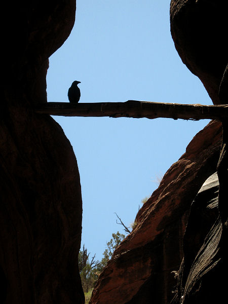
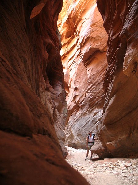
and head down Buckskin Gulch. The narrows begin
almost immediately as you head down canyon.
Walking conditions in the canyon can vary from
dry, slogging sand, to slippery mud, to loose
rocks to cold pools and wading. There is little
in the way of noticeable elevation change
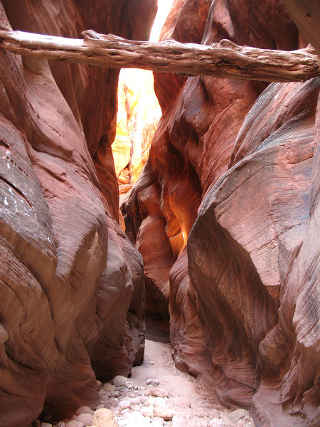
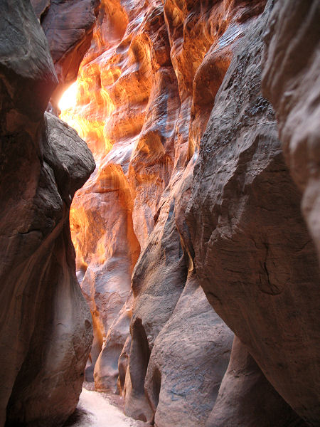
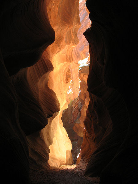
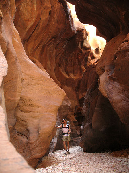
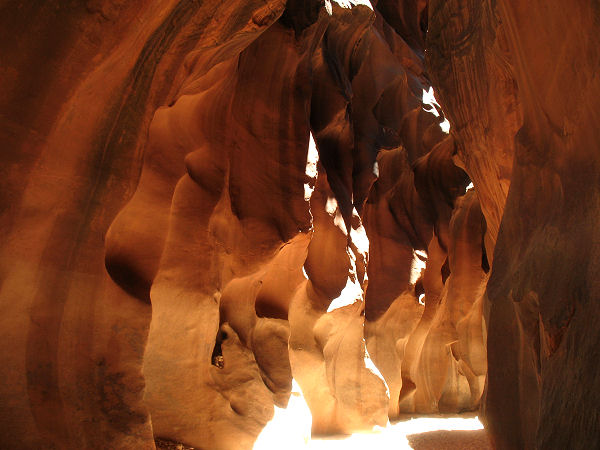
throughout the hike. Buckskin features beautiful
sculpted narrows throughout its length. The
color of the canyon will vary from gray, to gold
to orange and red depending on the depth, and
amount of light reaching into the canyon.
Because the canyon is so deep, much of the time
you will be hiking in shade. After several hours
of hiking, you will reach a point where there is
a break in the cliffs on canyon left which is
often marked with a cairn. This is where the
middle route enters and it is possible to climb
out of the canyon. There is a small petroglyph
panel high on the wall on the left just
downstream from the entry point. Below this
point, the canyon widens somewhat and becomes
more shallow. As you continue down stream, the
walls of the canyon slowly deepen and eventually
close in to form narrows once again. Eventually
you will arrive at a drop off formed by some
large boulders. There is often a rope fixed
around a log that will allow you to perform a 15
foot climb to the bottom. There are also some moki steps and a climbing route just to the left
of the log. Lower your pack down this obstacle
and have the more experienced climbers assist
the other members of your group down. Continuing
down canyon, water soon appears underfoot and
soon thereafter you will arrive at the
confluence with the Paria River. There are
campsites on benches in Buckskin Gulch just
up-canyon from the Paria. There is also another
decent campsite a short distance down the Paria
on the left. Watch where you step, the area
around the confluence has been heavily impacted
by inconsiderate hikers. Humanure and used
toilet paper abound. Most people obtain water
from the Paria at the confluence, but the
quality is dubious. There are springs
down-canyon in the Paria (most on the right hand
side), but you may have to walk quite a ways to
find one if conditions have been dry. When
ready, begin hiking up the Paria River. The
Paria is relatively wide compared with Buckskin,
but is quite scenic. As you head up-canyon you
will soon arrive at Slide Rock, a huge boulder
that has fallen into the canyon forming an arch.
After about an hour of hiking, the canyon walls
diminish and the river becomes a wide
floodplain. Continue up-canyon, avoiding deep
sand which slows your progress. After some
hiking, keep an eye on the right hand bank for a
fence line. Soon after the fence is identified a
trail leads from the river up to the White House
Trailhead and your car. |
| Rating (1-5 stars): |

The author has hiked in this area on numerous
occasions. Most recently I hiked down Buckskin
to the confluence with the Paria River in 6.5
hours and set up camp, then day hiked 2.5 hours
down the Paria and back for an 11.5 hour day.
The next day I hiked out to the White House
Trailhead in 3 hours. |
| Maps: |
None |
| Books: |
Canyon Hiking Guide to the Colorado Plateau
- Michael Kelsey
Hiking and
Exploring the Paria River
- Michael Kelsey |
| Photos: |
Click picture for larger view, click your browser's 'Back' button to return to this page. |
|
|