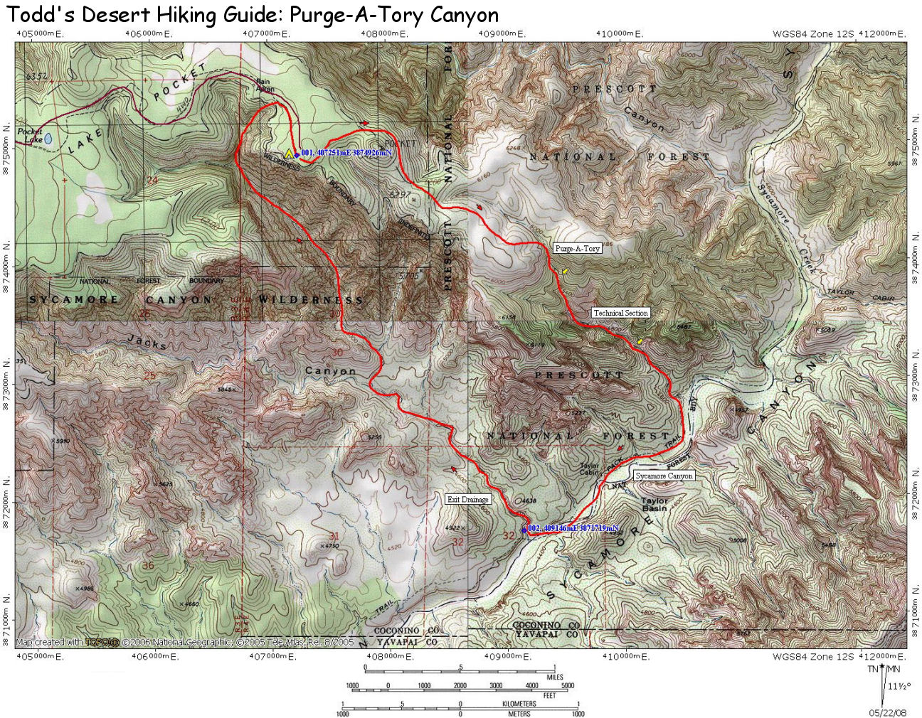
| Directions: |
Purge-A-Tory
Canyon is located south of Flagstaff in the
Coconino National Forest. From Prescott drive
north on Highway 89 past Chino Valley. Between
mileposts 346-347, turn east (right) at the sign
for Highway 71 which is initially paved, but
soon becomes dirt (ok for passenger cars).
Follow Highway 71 for 10 miles until you reach
an intersection at a paved road. Turn left
(north) on this road, which is listed as Forest
Road 173 on the map but is signed as 73. Just
after mile marker 176 turn right (east) on
Forest Road (FR) 354 at the sign for the
Overland Trailhead (well graded dirt). After
driving 7.2 miles FR 354 branches right and FR
105 continues straight. Stay straight on FR 105
until you reach right branching roads for FR 125
and FR 127. Turn right onto FR 127. After 2
miles FR 126 splits off to the right, stay on FR
127 for 4 more miles to where the road ends at a
small campsite. (GPS Point - UTM: 12S
407251mE, 3874926mN, WGS84 Datum). |
| Hike Description: |
From
the parking spot, route find east through the
scrub to identify the rounded mound of Pocket Hill.
The first objective is to skirt Pocket Hill to
the left (north). Once around the hill, follow
cow trails southeast for as long as you can
towards the V-shaped canyon below. When the
trail fades, thrash your way through the thick
brush choosing a path of least resistance to
arrive (somewhat scratched) at the bottom of the
Purge-A-Tory drainage. Once in the drainage
simply head down canyon. There are a few
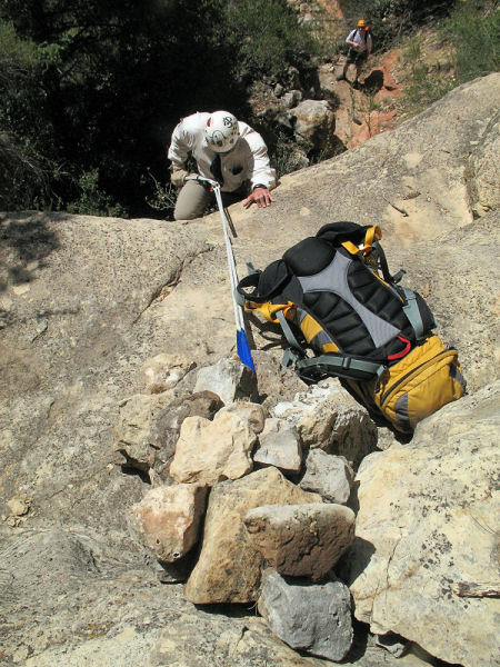
downclimbs and sections of thick brush to reach
a 45' cliff. Rappel this obstacle using a large
boulder at the top for an anchor. Not far below
is another rappel of 20' from a constructed rock
pile. Below is a 20' downclimb into a small
pool, followed by a Coconino sandstone chute,
which may also be negotiated without a rope.
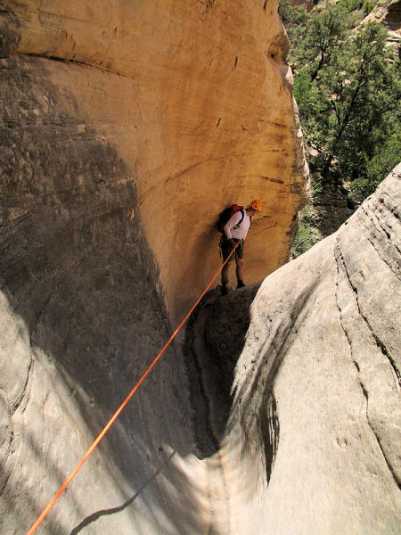
Next you'll come to a chute that has a steep 20'
drop off at the end. Rig webbing around a
cluster of stout shrubs on the left to rap down
the chute. The chute is followed by a double
nuisance drop from a tree on the right. Once
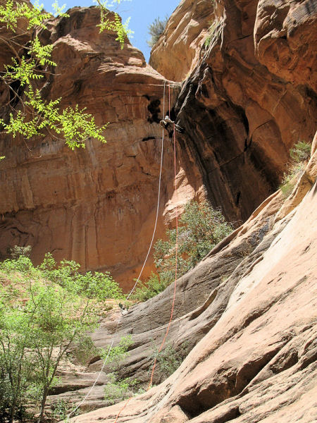
down, wrap webbing around the large boulder in
the middle of the canyon to perform a 200'
rappel into a nice alcove which marks the
boundary between the Coconino and the Supai
sandstone layers. Pull your rope, but don't remove your
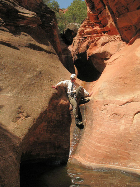
harness yet. Continue down through the Supai
which features a few nice sections of narrows
and several down climbs to reach the last
mandatory rappel, which is about 20' in length
using a tree on canyon right as the anchor.
A bit further down canyon, you'll encounter a
double drop (each into pools). Good climbers can
bypass the first downclimb and pool using a
ledge on the left,
but the second pool is unavoidable. With the obstacles behind, continue the
remainder of the way to the junction with
Sycamore Canyon (which is happily brush-free).
Once in Sycamore, turn right and rockhop down
canyon for a mile and a half or so (passing
Taylor Cabin as you do so) to reach an un-named
drainage which enters from the right
(GPS Point - UTM: 12S
409146mE, 3871719mN, WGS84 Datum). Turn right
and head up this drainage. The canyon twists and
turns, as it climbs gently through the strata
you so recently descended to eventually arrive
at an obvious fork. Take the right fork, which
soon begins climbing at a steeper grade as the
boulders increase in size. A few climbs are
required as you continue up canyon, including
one moderately tricky climb on the right (facing
up canyon) to avoid a shear pour off. Though the
climb isn't terribly difficult, there are a few
sections with a little exposure, and the climb
is followed by a rather unpleasant thrash
through thorny plants to get back into the
canyon above. Continue up, up and up, climbing
where necessary to eventually reach a minor
split in the upper reaches of the drainage. Stay
right to eventually climb up and out to the rim
above. Simply follow the drainage north until
you hit the road you drove in on earlier in the
day. Turn right and follow this road a short
distance back to your vehicle.
|
