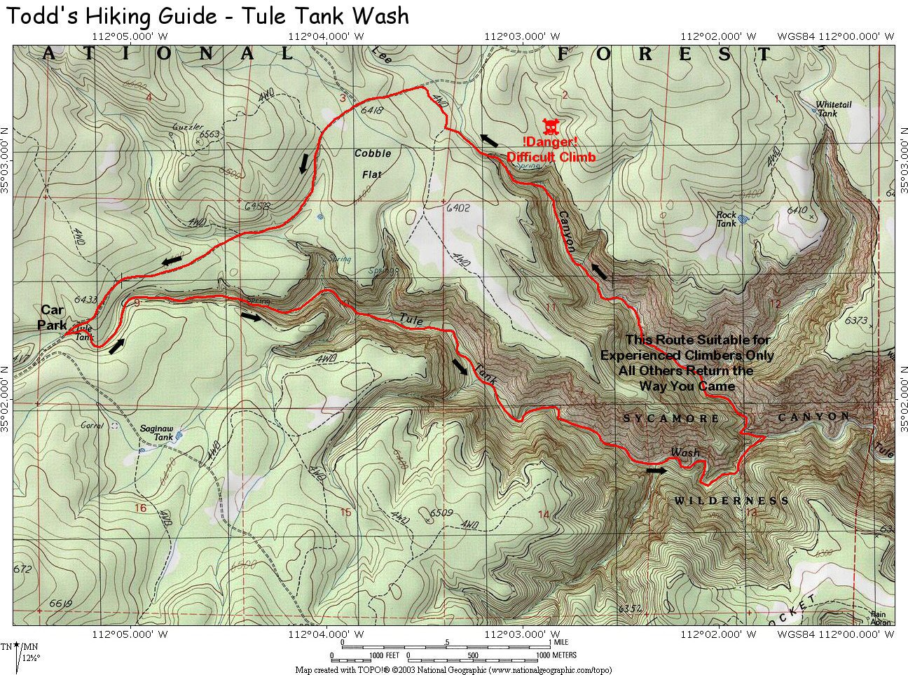
| |
Tule Tank Wash (w/Optional
Climbers Loop) - Coconino National Forest
| Summary: |
An off trail rock hop through
a seldom visited tributary of Sycamore Canyon.
An optional return route is described, however,
only strong climbers who are comfortable with
exposure should attempt this route. A map of the
hike may be found
here (496k). |
| Directions: |
From Prescott
drive north on Highway 89 past Chino Valley.
Turn east (right) at the sign for 71 which is
initially paved, but soon becomes dirt (ok for
passenger cars). Follow 71 for 10 miles until
you reach an intersection at a paved road. Turn
left (north) on this road which is listed as 173
on the map, but is signed as 73. Just after mile
marker 174 turn right (east) on Forest Road (FR)
354 at the sign for the Overland Trailhead (well
graded dirt). After driving 7.2 miles FR 354
branches right and FR 105 continues straight.
Stay straight on FR 105 driving past right
branching roads for FR 125 and FR 127.
Immediately after passing FR 127, the road
descends down a small hill and crosses a wash.
This wash is the start of Tule Tank Wash. Park
on the right next to the fire ring. |
| Road Conditions: |
Passenger Car |
| Navigation: |
Moderate |
| Length: |
~9.5 miles
for the loop described |
| Date Hiked: |
November
2003 |
| Weather Conditions: |
Cool and overcast |
|
Required Skills: |


 |
| Hike Description: |
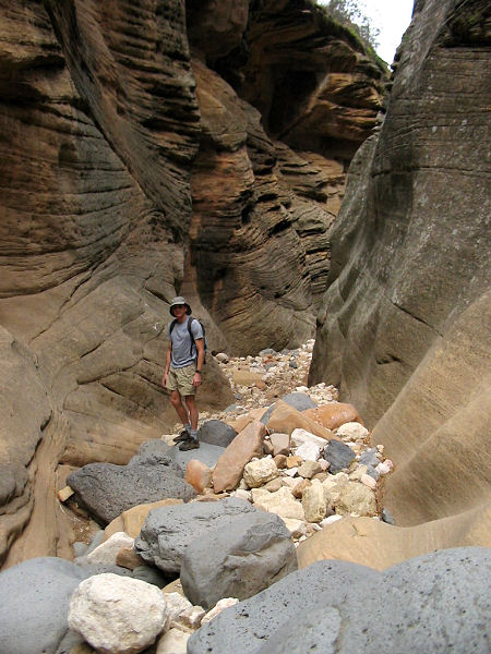
From the car park, simply
begin walking down the wash. You can avoid the
rocks at first by walking on the bank of the
wash on one side or the other, but soon you'll
be forced into the bed of the drainage to begin
the rock hopping that makes up the majority of
this hike. A word of warning, the rocks are
polished, smooth and slippery and some (even the
large ones) are prone to shifting when you step
on them. Use care as you proceed to avoid a bad
fall. The canyon is not terribly interesting as
you continue downstream, but at least there is
not much brush to contend with. After 20 minutes
or so, you'll hit a drop off, however, it's
easily down climbed by staying in the middle of
the canyon. Below the drop off the rocks
underfoot become boulder sized and the going
becomes somewhat slower. It's much the same for
the next several hours - rocks, rocks and more
.... oh .... I don't know .... could it be ....
rocks maybe? Two hours and 15 minutes from the
car park (walking quickly) the canyon makes an
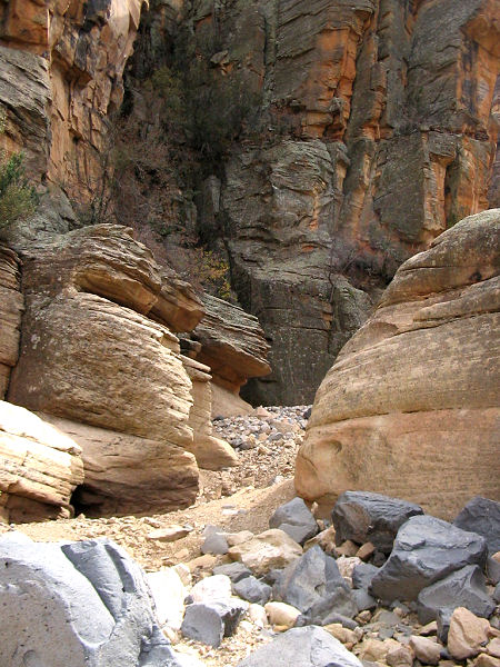
abrupt left turn and you'll enter a short
section of nice narrows. Unfortunately the fun
is over all too quickly and the canyon widens
once again at a junction with a left branching
side drainage. Turn around here, or continue
down canyon a ways before turning around (I
continued down another 45 minutes - ok canyon,
but no real narrows), return the way you came.
Optional Climbers Exit (not
recommended, unless you choose to bring climbing
protection and rope): This should only be
attempted by hikers with excellent climbing
skills that are comfortable with significant
exposure. Turn left and begin hiking up the side
drainage described above. After 15 minutes or so
canyon forks, stay in the left in the slightly
smaller drainage. More rock hopping (what else
is new) and you'll eventually reach a spot
marked by several cairns in the center of the
canyon. I believe this possibly marks an exit
trail used by hunters (on your left facing up
canyon). I went up this path a short distance,
but it was so faint, I decided to try my luck
with the canyon instead. A short distance above
these cairns you'll pass through a moderately
nice section of canyon. Then, as you progress
upwards, the boulders in the canyon bottom
become larger, and you'll be forced to do quite
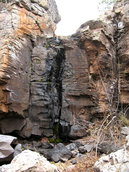
a bit of climbing and scrambling. Finally as you
reach the upper basalt layer that marks the head
of the canyon, your progress will be blocked by
a 45 foot shear cliff with a dripping spring.
There may be better ways out of the canyon at
this point, but the author decided to climb the
cliff band on canyon left (left side when facing
down canyon) at a crack about 100 feet back from
the headwall. The exit I chose consisted of
climbing 25 feet straight up along a crack to a
shelf, moving left along the shelf to another
crack, then climbing another 15 feet straight up
to a tree. There were good hand and foot holds
all along the route, but be aware that a fall
could be fatal. Once on top, follow the drainage
up canyon to a point where it is shallow enough
to cross. On the other side (the canyon will now
be on your left and to your back) hike northeast
along cow paths until you hit a 4-WD road.
Follow this road north until it reaches FR 105.
Turn left and follow FR 105 back to where it
crosses Tule Wash and your car. |
| Rating (1-5 stars): |

The author performed this hike solo as an
exploratory hike in search of canyoning
opportunities. I decided to use the side
drainage described as a return route and was not
terribly pleased to find that it cliffed out at
the topmost basalt layer. I was able to escape
by climbing up the cliff face at a crack on
canyon left. Had I known the cliff band were
there, would not have hiked this route. The
author hiked the route described above,
including an hour and a half spent exploring
below the confluence, in just over 6 hours. |
| Maps: |
Click
here (496k),
or Coconino National Forest Map |
| Books: |
None |
| Photos: |
Click picture for larger view, click your browser's 'Back' button to return to this page. |
 |
 |
|
Cliffs overlooking
Tule Canyon. |
The short narrows. |
 |
 |
Tule Canyon below
the confluence. |
Cliff at the
top of
the exit canyon. |
|
|
