| |
Casner Mountain Loop - Coconino
National Forest
| Summary: |
A long loop
hike which connects the Casner Mtn., Taylor
Cabin and Dogie Trails in the Sycamore Canyon
Wilderness. |
| Directions: |
From Phoenix
take I-17 north to Camp Verde to exit 285. Turn
left (west) onto Highway 260. Follow 260 to the
town of Cottonwood. Turn north onto Highway 89A
and drive 9 miles to milepost 364. Turn left
onto Forest Road (FR) 525 (also called Red
Canyon Road) and follow this well graded dirt
road 3 miles to it's intersection with FR 525C.
Turn left on 525C. After 3 miles (stay right at
the prominent split) you will reach a signed
intersection with left branching FR 761. Follow
the Sycamore pass sign straight, continuing on
525C. Drive 4 miles to where the road makes a
sharp left bend in a small depression. There is
a small, rusty metal Casner Mtn. Trail sign
(easy to miss) and one car pull out on the
right. Park here. |
| Road Conditions: |
Passenger Car |
| Navigation: |
Moderate |
| Length: |
~20 miles |
| Date Hiked: |
December
2002 |
| Weather Conditions: |
Cloudy and cool in the
morning, becoming sunny & nice |
|
Required Skills: |

 |
| Hike Description: |
From the car
park and Trail #8 Casner Mountain sign, begin
hiking on the OHV road as it begins climbing the
hill heading north towards Casner Mountain.
Shortly the road intersects with another road
under a set of power lines. You will be
following these power lines for the rest of the
Casner Mtn. hike. If you have not figured it out
by now, the Casner Mtn. Trail is really a right
of way. The road soon begins climbing very
steeply up the side of Casner Mtn. When you
reach a shoulder, you will have views to the east
down into Sycamore Canyon. Continue climbing
steeply past the buzzing poles & eventually you
will reach the top where you will find some
hitching posts made from left over power poles.
Continue following the road and lines as the
trail begins to descend (should be able to see
the San Francisco Peaks in the distance). The
road flattens out, then begins to bend to the
northwest and eventually begins following a
ridge (Buck Ridge on my map). There are a few
short but steep climbs along the ridge, and if
you are observant, you may spy a trail coming up
from the right and below. After a while, the
trail drops down into a pine tree studded saddle
at a signed junction with the right branching
Mooney Trail #123 (this is the path you saw
earlier) and the left branching Taylor Cabin
Trail #35 (6.5 miles). Turn left and follow the
Taylor Cabin Trail as it begins descending out
to a prominent butte. Before reaching this butte,
the path bends right and begins contouring and
descending the side of the slope. Before long, it
simply heads straight down (steeply) into the
canyon. As you get near the bottom, the trail
levels out and begins following a shallow
drainage on one side or the other. As you near
the end of this trail, you will be walking down
the middle of the drainage through a nice canyon
with red Supai sandstone walls. There are a few
narrow sections at pour overs along the way, but
these are easily avoided and though nice enough,
never become terribly exciting. Before long you
will enter into the dry, boulder strewn, main
drainage of Sycamore Canyon, which, true to its
name, contains some very old and large sycamore
trees (9 miles). You will want to turn left and
head down canyon, but before you do, scan the
opposite bank for cairns. The cairn piles on the
edges of the rocky creek bed lead up to some
nice stretches of trail along a bench above the
creek. Alternatively, you can rock hop right down
the canyon, but the bench walking is
considerably easier and more pleasant. At times,
the trails will dump you back into Sycamore
Canyon & you will have no choice but to rock
hop. After walking about 30-45 minutes, keep an
eye out on the right for a prominent cairn (just
opposite where another trail dumps you into the
creek from the left). The cairn marks an
extended section of good trail that leads along
the right hand bench through the manzanita,
scrub oak, juniper, prickly pear, pine &
mesquite. Soon you will reach a signed junction
just above Taylor Cabin. Note: the signs at this
junction confused me at the time, and now that I
have had a chance to look at several different
maps, can say that they still do not make sense.
The signs read: Sycamore Basin Trail #63
(right), #53 (right), #66 (back the way you came
and straight). Here is the source of my
confusion: the Beartooth map (referenced below)
says that you are on the Taylor Cabin Trail
(which is #35) and puts the intersection with
the Sycamore Basin Trail another 3 miles or so
down stream at the junction with the Dogie
Trail. This map also shows that the trail heads
straight down the creek bed below Taylor Cabin.
The Coconino NF map (which I didn't have with me
at the time), says that the entire trail along
Sycamore Creek is #63. Neither map lists trails
#66 or #53. What should you do? It may be that
the Sycamore Basin Trail #63 is the one you
want. I was not sure and opted for the safe, if
tedious, route directly down the stream bed. If
you choose this route you will pass Taylor Cabin
(a stone structure which had 4-5 backpackers
lounging around and smoke coming out the stack
when I was here - though I can't imagine why
since it was 11am), then a corral. Just below the
corral you are forced to walk in the stream bed
and its a rockin' boulder hop for the next hour
and a half or more. Eventually you will see some
prominent cairns on the right, left and middle
of the creek (maybe the trail entering on the
right is where you would come in had you
followed #63 from Taylor Cabin?). Turn left and
follow the cairns onto the unsigned Dogie Trail
(13.6 miles). The path climbs a bit, then begins
winding its way on a bench above Sycamore Creek.
The Dogie Trail gains and loses a small amount
of elevation at a moderate grade and is easy,
pleasant walking. After a while, the path drops
down a rocky hill, passes by Sycamore Basin Tank,
then bends east (away from the creek) and begins
heading towards a prominent gap in the red rock
hill side in the distance (the gap is Sycamore
Pass). It's easy walking for the most part with
one short, steep climb at the end up to the
pass, a fence line and register. Head through
the gate, and another 5 minute walk will bring
you to the road and Sycamore Pass Trailhead
(18.3). Follow the road back to your car (20
miles). |
| Rating (1-5 stars): |
 
The author slept in his car at the pull out
at the Casner Mtn. Trailhead. With an early
start and fast pace, he completed the loop
described in just under 8 hours. Other than the
initial climb up Casner Mountain, most of the
walking is fast and easy. |
| Maps: |
Bear Tooth
Maps: Sedona
Coconino National Forest Map |
| Photos: |
Click picture for larger view, click your browser's 'Back' button to return to this page. |
 |
 |
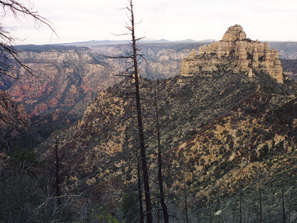
Butte seen at the start
of the Taylor Cabin Trail. |
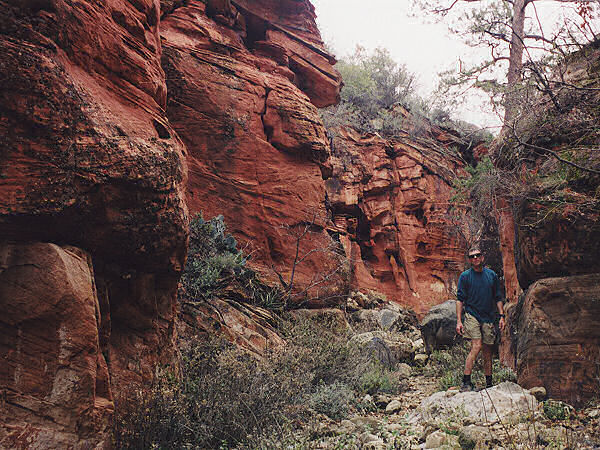
Supai
sandstone as you
approach Sycamore Canyon. |
|
|
